1850 HRDTM 1/512 Elbe approach
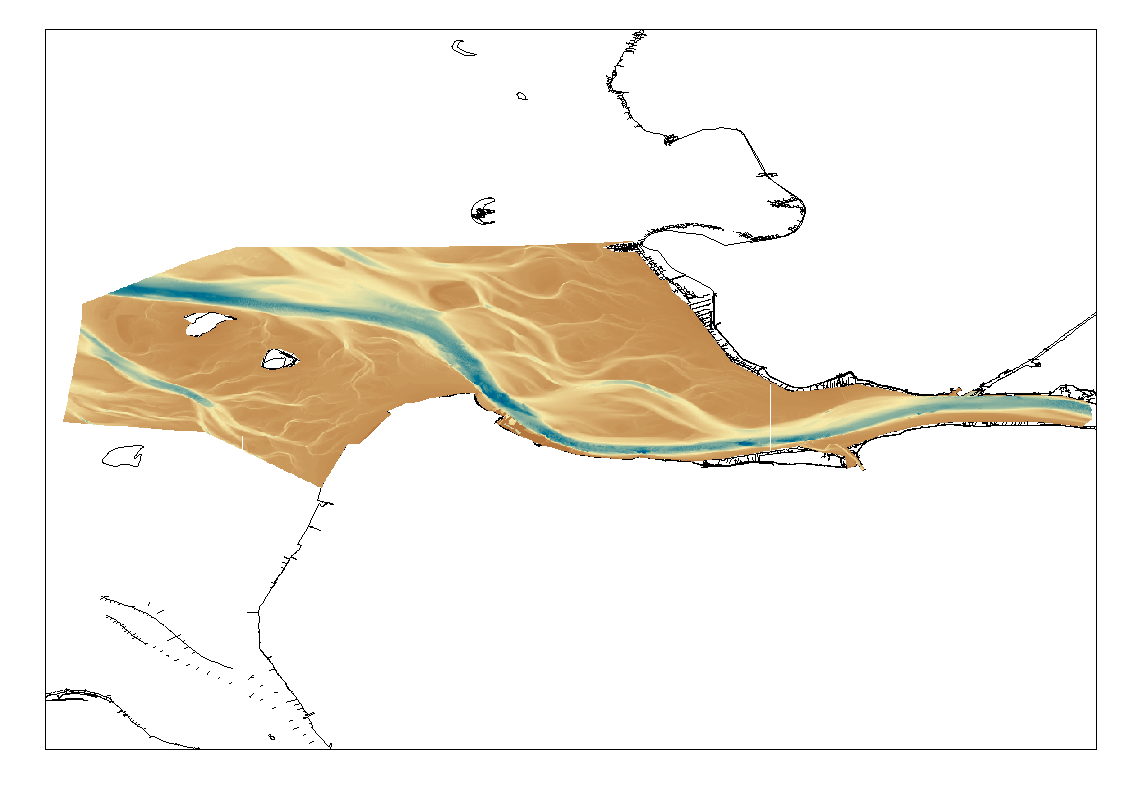
High Resolution DTM of the German Elbe Approach.
What
Metadata details
- File identifier
- SDN_CPRD_1850_DGMW_ELBE
- Catalogue type
-
Composite Product Record
-
Project name
-
-
EMODnet HRSM
-
- Dissemination level
-
public
- Metadata language
- English
- Date stamp
- 2023-05-05T08:02:06.741Z
Identification
- Dataset name
-
1850 HRDTM 1/512 Elbe approach
- Short name of dataset (SDN Local Product-ID)
-
DGMW_ELBE
-
Parameter Discovery Vocabulary (P02)
-
-
Bathymetry and Elevation
-
-
SeaDataNet device categories
-
-
single-beam echosounders
-
multi-beam echosounders
-
-
SeaDataNet device categories
-
-
Differential Global Positioning System receivers
-
Geometry
- Spatial representation type
- Grid
- Number of columns
- 1000000
- Number of lines
- 1000000
- Pixel size
- 1 Metres (m)
- Maximum scale of use
- 5000
Abstract
- Dataset description abstract
-
High Resolution DTM of the German Elbe Approach.
- Description of processed data sources
-
Description of processed data sources :SDN:CPRD:1850_DGMW_ELBE
Quality
Accuracy / Calibration
Quality Indicators
- Horizontal Quality Indicator
- 3 - < 20 m
- Vertical Quality Indicator
- 3 - Lidar, SBES high frequency
- Purpose Quality Indicator
- 3 - Hydrographic survey or compatible with hydrographic standards
Where
))
- Min. depth in meters (>0 below Sea Level)
- 78.9
- Max. depth in meters (>0 below Sea Level)
- -33.9
Projection
- code
-
ETRS89 (EPSG:4258)
- Version or custom projection details
-
7.4
When
Creation date
Revision date
Temporal extent*
- Begin
- 2010-01-01
- End
- 2010-12-31 Before
Who
Originator
- Organisation name
-
Federal Maritime and Hydrographic Agency
Data Holding Center
- Organisation name
-
Federal Maritime and Hydrographic Agency
Collating Centre = Metadata author
- Organisation name
-
Federal Maritime and Hydrographic Agency
Access
Distributor
- Organisation name
-
Federal Maritime and Hydrographic Agency
Data formats*
- Format
-
ASCII grid / ESRI grid
- OnLine resource
-
Protocol Linkage Name WWW:LINK
http://www.bsh.de WWW:LINK
https://tiles.emodnet-bathymetry.eu/ EMODnet Bathymetry WMTS service
WWW:LINK-1.0-http--link
https://emodnet.ec.europa.eu/geoviewer EMODnet viewer
- OnLine resource
-
Protocol Linkage Name WWW:DOWNLOAD-1.0-link--download
https://downloads.emodnet-bathymetry.eu/high_resolution/1850_elbe_alt_lw8-export-cdi-linear.emo.zip WWW:DOWNLOAD-1.0-link--download
https://downloads.emodnet-bathymetry.eu/high_resolution/1850_elbe_alt_lw7-export-cdi-linear.emo.zip WWW:DOWNLOAD-1.0-link--download
https://downloads.emodnet-bathymetry.eu/high_resolution/1850_elbe_alt_lw6-export-cdi-linear.emo.zip WWW:DOWNLOAD-1.0-link--download
https://downloads.emodnet-bathymetry.eu/high_resolution/1850_elbe_alt_lw5-export-cdi-linear.emo.zip WWW:DOWNLOAD-1.0-link--download
https://downloads.emodnet-bathymetry.eu/high_resolution/1850_elbe_alt_lw4-export-cdi-linear.emo.zip WWW:DOWNLOAD-1.0-link--download
https://downloads.emodnet-bathymetry.eu/high_resolution/1850_elbe_alt_lw3-export-cdi-linear.emo.zip WWW:LINK
https://tiles.emodnet-bathymetry.eu/ EMODnet Bathymetry WMTS service
Intellectual property
- Access constraints
- Creative Commons Attribution 4.0 International
- Use constraints
- Other restrictions
- Other constraints
-
DO NOT USE FOR NAVIGATION
)))