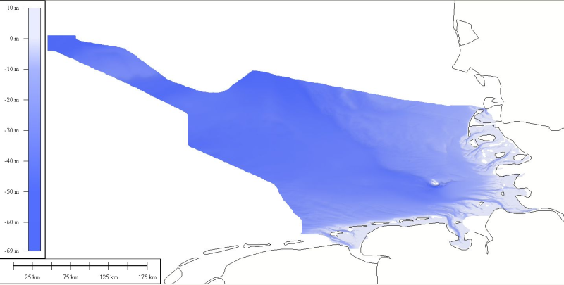
1850_EMODNET REGIONAL DTM OF GERMAN CONTINENTAL SHELF
DTM data source was received from the data center (Bathymetrisches Datenzentrum) of the German Hydrographic Office (Bundesamt für Seeschifffahrt und Hydrographie) at a variable resolution. The data was then processed by ATLIS b.v. using the ATLIS SENS software suite and compiled into an EMODnet regional DTM. Although the resolution varied throughout the dataset, no interpolation was required to create a geographic grid of 0.0041667 degrees resolution.
What
Metadata details
- File identifier
- SDN_CPRD_1850_GERMANY-DTM-1
- Catalogue type
-
Composite Product Record
-
Project name
-
-
EMODNet Hydrography
-
- Dissemination level
-
public
- Metadata language
- English
- Date stamp
- 2018-01-22T11:19:10
Identification
- Dataset name
-
1850_EMODNET REGIONAL DTM OF GERMAN CONTINENTAL SHELF
- Short name of dataset (SDN Local Product-ID)
-
GERMANY-DTM-1
-
Parameter Discovery Vocabulary (P02)
-
-
Bathymetry and Elevation
-
-
SeaDataNet device categories
-
-
single-beam echosounders
-
multi-beam echosounders
-
Geometry
- Spatial representation type
- Grid
- Number of columns
- 605
- Number of lines
- 1420
- Pixel size
- 0.0041667 Degrees north (degree_north)
- Maximum scale of use
- 500000
Abstract
- Dataset description abstract
-
DTM data source was received from the data center (Bathymetrisches Datenzentrum) of the German Hydrographic Office (Bundesamt für Seeschifffahrt und Hydrographie) at a variable resolution. The data was then processed by ATLIS b.v. using the ATLIS SENS software suite and compiled into an EMODnet regional DTM. Although the resolution varied throughout the dataset, no interpolation was required to create a geographic grid of 0.0041667 degrees resolution.
- Description of processed data sources
-
Description of processed data sources :
- Description of data processing
-
Description of data processing :
Quality
Accuracy / Calibration
Hor. accuracy
- Measure description
-
IHO S-44
- Value
- IHO S-44
- Evaluation method description
-
IHO S-44
Vert. accuracy
- Measure description
-
IHO S-44
- Evaluation method description
-
IHO S-44
Suitability
- Suitability, Expected type of users / uses and limitations
-
Please refer to www.bsh.de for the terms of use (Bathymetrisches Datenzentrum)
Where
))
- Min. depth in meters (>0 below Sea Level)
- -10
- Max. depth in meters (>0 below Sea Level)
- 69.3
Projection
- code
-
WGS 84 (EPSG:4326)
- Version or custom projection details
-
7.4
When
Creation date
Revision date
Temporal extent*
- Begin
- 1970-01-01T16:17:00
Who
Originator
- Organisation name
-
Federal Maritime and Hydrographic Agency
Data Holding Center
- Organisation name
-
Federal Maritime and Hydrographic Agency
Collating Centre = Metadata author
- Organisation name
-
ATLIS
Access
Distributor
- Organisation name
-
Federal Maritime and Hydrographic Agency
Data formats*
- Format
-
xyz
- Version
-
1.0
- OnLine resource
-
Protocol Linkage Name WWW:LINK
http://www.bsh.de
Intellectual property
- Use limitation
-
See www.bsh.de
- Access constraints
- License
- Use constraints
- Copyright
)))