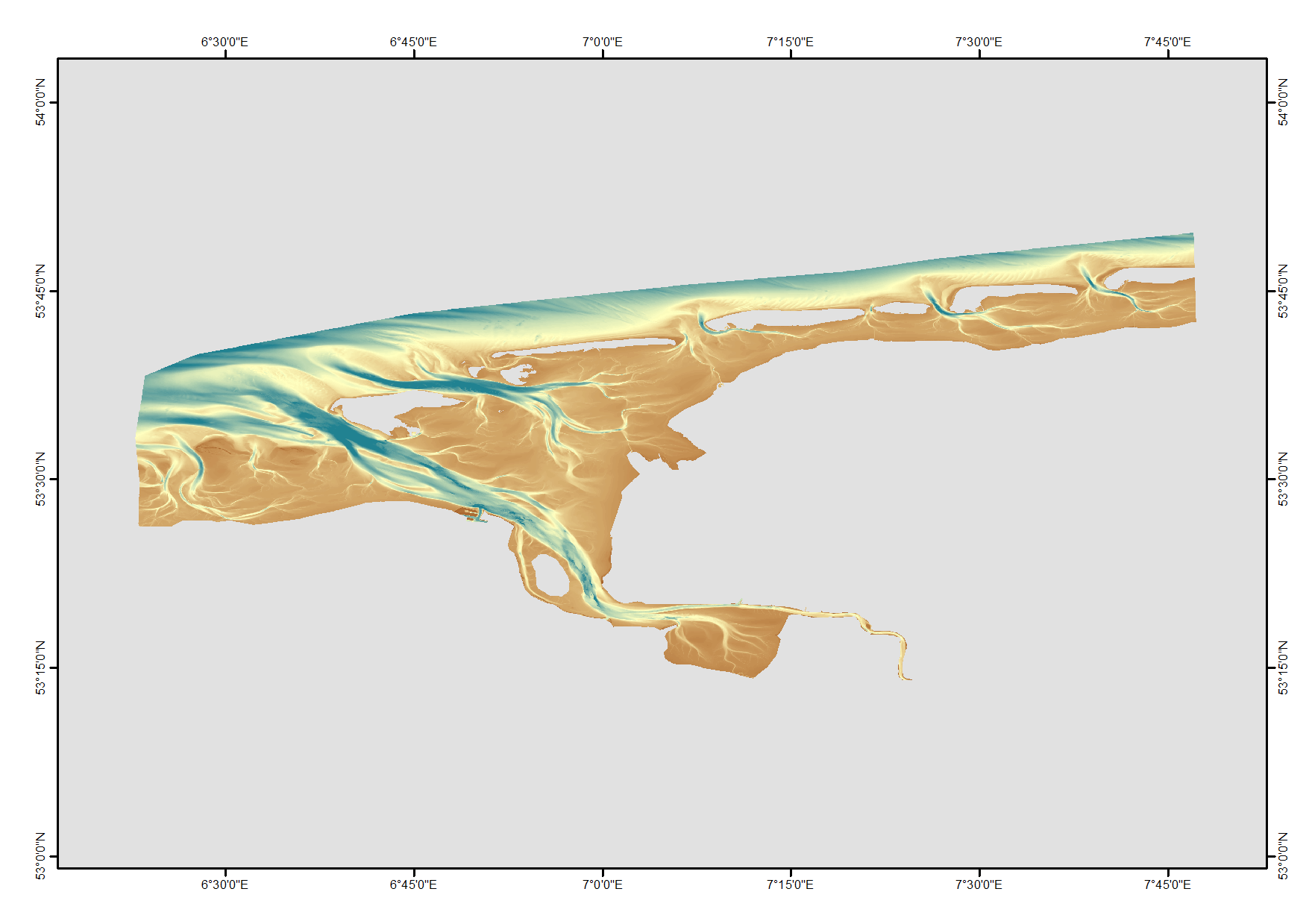
HRDTM 1/512 Ems approach - Version 2
High resolution composite DTM based on single beam, multi beam and Lidar covering the Ems and Ems approach. All data acquired in the years 2012-2015.
What
Metadata details
- File identifier
- SDN_CPRD_1850_UAEms_2015
- Catalogue type
-
Product record
-
Project name
-
-
EMODnet HRSM
-
- Dissemination level
-
public
- Metadata language
- English
- Date stamp
- 2022-09-21T09:03:16.293Z
Identification
- Dataset name
-
HRDTM 1/512 Ems approach - Version 2
- Short name of dataset (SDN Local Product-ID)
-
UAEms_2015
-
Parameter Discovery Vocabulary (P02)
-
-
Bathymetry and Elevation
-
-
SeaDataNet device categories
-
-
multi-beam echosounders
-
single-beam echosounders
-
-
SeaDataNet device categories
-
-
Differential Global Positioning System receivers
-
Geometry
- Spatial representation type
- Grid
- Number of columns
- 47336
- Number of lines
- 17743
- Pixel size
- 0.00195313 Arc minute
- Maximum scale of use
- 5000
Abstract
- Dataset description abstract
-
High resolution composite DTM based on single beam, multi beam and Lidar covering the Ems and Ems approach. All data acquired in the years 2012-2015.
- Description of processed data sources
-
CDIs: 96_9411514, 96_9411511, 96_9411515, 96_9411516, 96_9411512, 96_9411513, 96_SVE_9441501, 96_SVE_y1985, 96_9411506, 96_9411505, 96_9411501, 96_9411504, 96_SVE_9401501, 96_9411502, 96_9441502, 96_9411503, 96_9401502, 96_9401503, 96_9401504, 96_9391502, 96_9391501, 96_9441503, 96_9441504, 96_9391503, 96_9391504, 96_9441505, 96_9381500, 96_9371501, 96_9371502, 96_9361501, 96_9361502, 96_9361503, 96_9441506
- Description of data processing
-
Description of data processing :
Quality
Accuracy / Calibration
Hor. accuracy
- Measure description
-
1.0
Vert. accuracy
- Measure description
-
0.4
Quality Indicators
- Horizontal Quality Indicator
- 3 - < 20 m
- Vertical Quality Indicator
- 3 - Lidar, SBES high frequency
- Purpose Quality Indicator
- 3 - Hydrographic survey or compatible with hydrographic standards
Where
))
- Min. depth in meters (>0 below Sea Level)
- 0
- Max. depth in meters (>0 below Sea Level)
- 27.8
Projection
- code
-
WGS 84 (EPSG:4326)
- Version or custom projection details
-
7.4
When
Creation date
- date
- 2016-06-28
Revision date
Temporal extent*
- Begin
- 2010-01-01
- End
- 2016-03-15
Who
Originator
Data Holding Center
Collating Centre = Metadata author
Access
Distributor
Data formats*
- Format
-
ASCII/NetCDF
- Transfer size (in MB)
- 900
- OnLine resource
Intellectual property
- Access constraints
- Creative Commons Attribution 4.0 International
- Use constraints
- Other restrictions
- Other constraints
-
DO NOT USE FOR NAVIGATION
accessData
Overviews Aperçus
)))