2979_EMEPC_LH1_250_West_Central_Continental_Shelf_Portugal
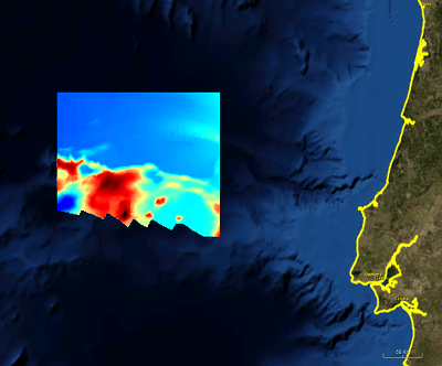
DTM derived from a hydrographic survey (EMEPC LH1) performed within the scope of the Portuguese Continental Shelf Extension Project (UNCLOS). The data made available to the Emodnet project was sampled from the survey data with an aproximate 250m sampling interval, in N-S and E-W directions.
What
Metadata details
- File identifier
- SDN_CPRD_2979_EMEPC_LH1_250
- Catalogue type
-
Composite Product Record
-
Project name
-
-
EMODNet Hydrography
-
- Dissemination level
-
confidential
- Metadata language
- English
- Date stamp
- 2018-01-29T16:50:25
Identification
- Dataset name
-
2979_EMEPC_LH1_250_West_Central_Continental_Shelf_Portugal
- Short name of dataset (SDN Local Product-ID)
-
EMEPC_LH1_250
-
Parameter Discovery Vocabulary (P02)
-
-
Bathymetry and Elevation
-
Geometry
- Spatial representation type
- Grid
- Number of columns
- 936
- Number of lines
- 640
- Pixel size
- 250 Metres (m)
- Maximum scale of use
- 200000
Abstract
- Dataset description abstract
-
DTM derived from a hydrographic survey (EMEPC LH1) performed within the scope of the Portuguese Continental Shelf Extension Project (UNCLOS). The data made available to the Emodnet project was sampled from the survey data with an aproximate 250m sampling interval, in N-S and E-W directions.
- Description of data processing
-
Description of data processing :
CARIS HIPS Data processing and Validation Procedures.
Sound Velocity Profiles were made whenever the sound velocity presented significant variations.
- Processing software
-
Caris Hips and Sips
Quality
Accuracy / Calibration
Hor. accuracy
- Evaluation method description
-
Size of grid and data samping interval
Suitability
- Suitability, Expected type of users / uses and limitations
-
Not for navigation.
Quality Indicators
- Horizontal Quality Indicator
- 3 - < 20 m
- Vertical Quality Indicator
- 2 - MBES low frequency (lower than 100kHz) (similar than 1+2%d)
- Purpose Quality Indicator
- 3 - Hydrographic survey or compatible with hydrographic standards
Where
))
- Min. depth in meters (>0 below Sea Level)
- 2416
- Max. depth in meters (>0 below Sea Level)
- 5540
Projection
- code
-
WGS 84 (EPSG:4326)
- Version or custom projection details
-
7.4
When
Creation date
Revision date
Temporal extent*
- Begin
- 2005-02-10T00:00:00
- End
- 2005-04-14T00:00:00
- Measurement frequency
- hour
Who
Originator
- Organisation name
-
EMEPC - Estrutura de Missao para a Extensao da Plataforma Continental
Data Holding Center
- Organisation name
-
EMEPC - Estrutura de Missao para a Extensao da Plataforma Continental
Collating Centre = Metadata author
- Organisation name
-
IPMA - Instituto Portugues do Mar e da Atmosfera
Access
Distributor
- Organisation name
-
EMEPC - Estrutura de Missao para a Extensao da Plataforma Continental
Data formats*
- Format
-
Text
- Version
-
1.0
- Transfer size (in MB)
- 10
- OnLine resource
-
Protocol Linkage Name WWW:LINK
http://www.emepc.pt/
Intellectual property
- Access constraints
- Restricted
- Use constraints
- Restricted
)))