353_291001-Alboran Sea
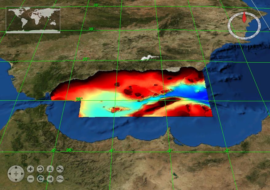
Composite DTM of Alborán Sea at approximately 250m of resolution
What
Metadata details
- File identifier
- SDN_CPRD_353_291001
- Catalogue type
-
Composite Product Record
-
Project name
-
-
EMODNet Hydrography
-
- Dissemination level
-
public
- Metadata language
- English
- Date stamp
- 2018-01-18T13:07:33
Identification
- Dataset name
-
353_291001-Alboran Sea
- Short name of dataset (SDN Local Product-ID)
-
291001
-
Parameter Discovery Vocabulary (P02)
-
-
Bathymetry and Elevation
-
-
Measuring devices
-
-
multi-beam echosounders
-
-
Measuring devices
-
-
Differential Global Positioning System receivers
-
Geometry
- Spatial representation type
- Grid
- Pixel size
- 0.0027 Degrees (deg)
- Maximum scale of use
- 200000
Abstract
- Dataset description abstract
-
Composite DTM of Alborán Sea at approximately 250m of resolution
- Description of processed data sources
-
Description of processed data sources :
This DTM has been elaborated from two grids (ArcGis raster format), both treated with the IDW method.
The first is a grid of 25 x 25 meters of resolution derived from a MBES SIMRAD 1000 survey with information about continental shelf and slope. The depths are between 5 and 160 meters.
The vertical datum is the zero of the patron port of Malaga (in Alboran W).
This information has been obtained in the ESPACE project. Spanish Institute of Oceanography.
The second is a grid of 100 x 100 meters of resolution derived from a MBES SIMRAD 300 survey with information for depths greater than 160 meters, for all Alborán sea. The vertical datum is the sea level. This information has been obtained in the CARPEMA project.
- Description of data processing
-
Description of data processing :
No harmonisation of vertical datum have been applied when merging data sources (compatibility with Sea Level in a few tens of cm near)).
Source data received from data owners were DTM in GRID format (raster format ArcGis, structured in a matrix regular bathymetry associated with the centre of the cell of two types of format (raster format of ArcGis) with different resolutions. From each grid, we obtained a point SHAPE file, each point corresponds to the centre of the cell on the grid. Each point has the depth value of each cell. With each point SHAPE file, we use de command IDW (ArcGis) to realize an IDW Interpolation, (assigning weight in function of inverse of the distance). We have worked with the number of points that produced less error, in each case.When the DTM is composed by several grids with MOSAIC command of ArcGis, never these grids are intersecting between them; the grids are adjacent with a small zone of intersection to avoid the appearance of holes.
- Processing software
-
ArcGis IDW
Quality
Accuracy / Calibration
Hor. accuracy
- Evaluation method description
-
In all case, multiple tests have been made in order to use the method which would introduce less error in the result
Vert. accuracy
- Evaluation method description
-
In all case, multiple tests have been made in order to use the method which would introduce less error in the result
Suitability
- Suitability, Expected type of users / uses and limitations
-
Not for navigation
Where
))
- Min. depth in meters (>0 below Sea Level)
- 3.35
- Max. depth in meters (>0 below Sea Level)
- 1988
Projection
- code
-
WGS 84 (EPSG:4326)
- Version or custom projection details
-
7.4
When
Creation date
Revision date
Temporal extent*
- Begin
- 2000-01-01T00:00:00
- End
- 2003-12-31T00:00:00
Who
Originator
- Organisation name
-
Istituto Espanol de Oceanografia (IEO)
Data Holding Center
- Organisation name
-
Istituto Espanol de Oceanografia (IEO)
Collating Centre = Metadata author
- Organisation name
-
Istituto Espanol de Oceanografia (IEO)
Access
Distributor
- Organisation name
-
Istituto Espanol de Oceanografia (IEO)
Data formats*
- Format
-
ESRI GRD
- Version
-
unknown
- OnLine resource
-
Protocol Linkage Name WWW:LINK
http://www.ieo.es/ Web site of the Istituto Espanol de Oceanografia (IEO)
Intellectual property
- Access constraints
- Restricted
- Use constraints
- Copyright
- Other constraints
-
Contact josel.sanz@md.ieo.es
)))