353_291006-Levante margin
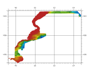
Composite DTM of the Levante margin, at approximately 100m of resolution .
What
Metadata details
- File identifier
- SDN_CPRD_353_291006
- Catalogue type
-
Composite Product Record
-
Project name
-
-
EMODNet Hydrography
-
- Dissemination level
-
public
- Metadata language
- English
- Date stamp
- 2020-06-04T00:23:32
Identification
- Dataset name
-
353_291006-Levante margin
- Short name of dataset (SDN Local Product-ID)
-
291006
-
Parameter Discovery Vocabulary (P02)
-
-
Bathymetry and Elevation
-
-
SeaDataNet device categories
-
-
single-beam echosounders
-
multi-beam echosounders
-
-
SeaDataNet device categories
-
-
Differential Global Positioning System receivers
-
Geometry
- Spatial representation type
- Grid
- Pixel size
- 0.002 Degrees north (degree_north)
- Maximum scale of use
- 200000
Abstract
- Dataset description abstract
-
Composite DTM of the Levante margin, at approximately 100m of resolution .
- Description of processed data sources
-
Description of processed data sources :
This DTM has been elaborated from several grids (ArcGis raster format), with the IDW method . This information has been obtained from different surveys: MARISBAL, CARPEMA, ESPACE, and others realized by different institutions and private companies. The instruments used have been MBES (SIMRAD) and SBES. Vertical Datum: Sea level
- Description of data processing
-
Description of data processing :
For this area the IEO has collated information in two different formats.
1. The IEO got this information in vectorial format as isobaths with different equidistance, from 10 meters to 200 meters, according to depth. From this isobaths and using the TOPOGRID (command for interpolation a MDT from isobaths) a second DTM was made with 250meters of resolution. 2. The other information has been obtained with echosounder multibeam in several surveys. These data have been processed, filtered, and finally from these data have been made a first DTM : for each data owner we have a grid for each survey. These grids have been treated with the IDW method to obtain a MDT of 250 meters of resolution. Later these DTM have been transformed to Geographic Coordinates with the PROJECT command of ArcGis software, with a resolution of 0,0020 decimal degrees . Finally a single DTM for this zone was created with the MOSAIC command of ArcGis, in this case never these grids are intersecting between them; the grids are adjacent with a small zone of intersection to avoid the appearance of holes.
- Processing software
-
ArcGIS
Quality
Accuracy / Calibration
Hor. accuracy
- Measure description
-
Not specified
- Evaluation method description
-
In all case, multiple tests have been made in order to use the method which would introduce less error in the result.
Vert. accuracy
- Measure description
-
ot specified
- Evaluation method description
-
In all case, multiple tests have been made in order to use the method which would introduce less error in the result.N
Suitability
- Suitability, Expected type of users / uses and limitations
-
Not for navigation
Quality Indicators
- Horizontal Quality Indicator
- -1 - Multisources
- Vertical Quality Indicator
- -1 - Multisources
- Purpose Quality Indicator
- 2 - Bathymetric/morphologic survey
Where
))
- Min. depth in meters (>0 below Sea Level)
- 0
- Max. depth in meters (>0 below Sea Level)
- 2939
Projection
- code
-
WGS 84 (EPSG:4326)
- Version or custom projection details
-
7.4
When
Creation date
Revision date
Temporal extent*
- Begin
- 1977-04-01T12:00:00
- End
- 2005-10-01T12:00:00
Who
Originator
- Organisation name
-
Istituto Espanol de Oceanografia (IEO)
Data Holding Center
- Organisation name
-
Istituto Espanol de Oceanografia (IEO)
Collating Centre = Metadata author
- Organisation name
-
Istituto Espanol de Oceanografia (IEO)
Access
Distributor
- Organisation name
-
Istituto Espanol de Oceanografia (IEO)
Data formats*
- Format
-
ESRI GRD
- Version
-
Not specified
- OnLine resource
-
Protocol Linkage Name WWW:LINK
http://www.ieo.es/
Intellectual property
- Access constraints
- Restricted
- Use constraints
- Copyright
- Other constraints
-
Contact ideo@ieo.es
)))