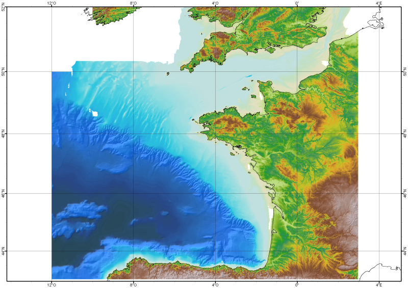
486_Bathymetry_Bay of Biscay - Channel (DTM resolution : 1000m ; ed. : 2008)
The Digital Terrain Model of the Bay of Biscaye and of the Channel is the result of the processing of a compilation of single and multibeam echosounder data, of DTMs and of chart countours produced before 2008 for hydrodynamic modeling..
What
Metadata details
- File identifier
- SDN_CPRD_486_IFR_MBAN_MANCHEGASC_1000_01_R
- Catalogue type
-
Composite Product Record
-
Project name
-
-
EMODNet Seabed Mapping
-
- Dissemination level
-
public
- Metadata language
- English
- Date stamp
- 2021-08-19T10:44:37
Identification
- Dataset name
-
486_Bathymetry_Bay of Biscay - Channel (DTM resolution : 1000m ; ed. : 2008)
- Short name of dataset (SDN Local Product-ID)
-
IFR_MBAN_MANCHEGASC_1000_01_R
-
Parameter Discovery Vocabulary (P02)
-
-
Bathymetry and Elevation
-
-
SeaDataNet device categories
-
-
single-beam echosounders
-
multi-beam echosounders
-
Geometry
- Spatial representation type
- Grid
- Number of columns
- 1033
- Number of lines
- 1162
- Pixel size
- 1000 Metres (m)
- Maximum scale of use
- 1000000
Abstract
- Dataset description abstract
-
The Digital Terrain Model of the Bay of Biscaye and of the Channel is the result of the processing of a compilation of single and multibeam echosounder data, of DTMs and of chart countours produced before 2008 for hydrodynamic modeling..
- Description of processed data sources
-
Description of processed data sources :
Several sources have used among which : the multibeam echo sounder surveys from Ifremer (Seabeam, EM12D, EM 300) in the French EEZ in waters usually deeper than 200m), DTMs at 500m of resolution produced by SHOM using soundings of its bathymetric Data Base on the French continental shelf, digitized bathymetric maps pusbished by Berthois from 1974 to 1983 gridded at 500m of resolution, the SRMT 30 arc second topographic model.
- Description of data processing
-
Description of data processing : Data processing has been carried out using krieging for data derived from contours, and simpler griding and merging algorithm for high data density (soundings and source DTMs).
- Processing software
-
Isatis (Geovariances), GMT, Caraibes (Ifremer)
Quality
Accuracy / Calibration
Hor. accuracy
- Measure description
-
Depends on the source of data : of the order of 0.05 minute to 1 minute
- Evaluation method description
-
Rough estimate from accuracies of maps and of positioning systems of the surveys
Vert. accuracy
- Measure description
-
Usually better than the GEBCO version available at the time of the creation of the DTM
- Evaluation method description
-
Visual comparison together with information on the source data
Suitability
- Suitability, Expected type of users / uses and limitations
-
Not for navigation.
Where
))
- Min. depth in meters (>0 below Sea Level)
- 0
- Max. depth in meters (>0 below Sea Level)
- 5174
Projection
- code
-
WGS 84 (EPSG:4326)
- Version or custom projection details
-
7.4
When
Creation date
Revision date
Temporal extent*
- Begin
- 1900-01-01T00:00:00
- End
- 2007-12-31T00:00:00
Who
Originator
- Organisation name
-
IFREMER / GM-MARINE GEOSCIENCES
- Country
-
France
Data Holding Center
- Organisation name
-
IFREMER / IDM / SISMER - Scientific Information Systems for the SEA
- Country
-
France
Collating Centre = Metadata author
- Organisation name
-
IFREMER / IDM / SISMER - Scientific Information Systems for the SEA
- Country
-
France
Access
Distributor
- Organisation name
-
EDMO name
- Organisation name
-
IFREMER / IDM / SISMER - Scientific Information Systems for the SEA
- Country
-
France
Data formats*
- Format
-
NetCDF
- Version
-
3
- Transfer size (in MB)
- 2.5
Intellectual property
- Access constraints
- Restricted
- Use constraints
- Copyright
- Other constraints
-
(c) Ifremer - SHOM 2010
Obligation of citation :
Loubrieu B., Bourillet J.F., Moussat E.Bathy-morphologie régionale du Golfe de Gascogne et de la Manche, modèle numérique 2008 - Rapport interne Ifremer DCD/GM/CTDI/08-01.
(c) SHOM 2006 Works carried out using data transmitted by Service Hydrographique et Océanographique de la Marine (contract E97-2006) - www.shom.fr - SHOM is not responsible of the results and of the use of the results. All rights reserved except for Research and Education.
)))