543_EMODNET REGIONAL DTM FOR NORWAY AREA OF INTEREST
DTM data source was created by taking contour lines and spot soundings from Norwegian Electronic Navigational Charts. NOTE: Data east of appr.
What
Metadata details
- File identifier
- SDN_CPRD_543_NORWAY-DTM-1
- Catalogue type
-
Composite Product Record
-
Project name
-
-
EMODNet Hydrography
-
- Dissemination level
-
public
- Metadata language
- English
- Date stamp
- 2023-09-25T14:05:11.07Z
Identification
- Dataset name
-
543_EMODNET REGIONAL DTM FOR NORWAY AREA OF INTEREST
- Short name of dataset (SDN Local Product-ID)
-
NORWAY-DTM-1
-
Parameter Discovery Vocabulary (P02)
-
-
Bathymetry and Elevation
-
Geometry
- Spatial representation type
- Grid
- Number of columns
- 2653
- Number of lines
- 1530
- Pixel size
- 200 Metres (m)
- Maximum scale of use
- 500000
Abstract
- Dataset description abstract
-
DTM data source was created by taking contour lines and spot soundings from Norwegian Electronic Navigational Charts. NOTE: Data east of appr.
- Description of processed data sources
-
Description of processed data sources : Electronic Navigational Charts of the Norwegian Hydrographic Office.
- Description of data processing
-
Description of data processing :
The resulting data set was gridded and interpolated by TCarta using ANUDEM v5.2 software. ATLIS b.v. processed this dataset into an EMODnet compliant regional DTM using the ATLIS SENS software suite.
The DTM version 1.0 was larger than the current version and covered most of the Northsea. Analysis showed however that the quality of the dataset in the central and southern Northsea was less than existing GEBCO data. It was therefore decided to only use reduce the original DTM to its current size.
Note: no original survey data has been used for the compilation of this DTM.
Quality
Accuracy / Calibration
Suitability
- Suitability, Expected type of users / uses and limitations
-
Please refer to http://www.statkart.no/eng/Norwegian_Hydrographic_Service/ for the terms of use
Quality Indicators
- Horizontal Quality Indicator
- Vertical Quality Indicator
- Purpose Quality Indicator
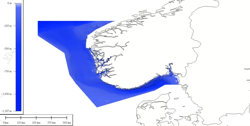
Where
))
- Min. depth in meters (>0 below Sea Level)
- 0.0
- Max. depth in meters (>0 below Sea Level)
- 1187.65
Projection
- code
-
WGS 84 (EPSG:4326)
- Version or custom projection details
-
7.4
When
Creation date
Revision date
Temporal extent*
- Begin
- 1900-01-01T16:39:00
- End
- 2010-02-15T04:00:00
Who
Originator
- Organisation name
-
Norwegian Hydrographic Service
Data Holding Center
- Organisation name
-
Norwegian Hydrographic Service
Collating Centre = Metadata author
- Organisation name
-
ATLIS
Access
Distributor
- Organisation name
-
Norwegian Hydrographic Service
Data formats*
- Format
-
Text
- Version
-
1.0
- Transfer size (in MB)
- 1
- OnLine resource
-
Protocol Linkage Name WWW:LINK
http://www.statkart.no/eng/Norwegian_Hydrographic_Service/ Website of the Norwegian Hydrographic Office
Intellectual property
- Use limitation
-
see http://www.statkart.no/eng/Norwegian_Hydrographic_Service/
- Access constraints
- License
- Use constraints
- Copyright
)))