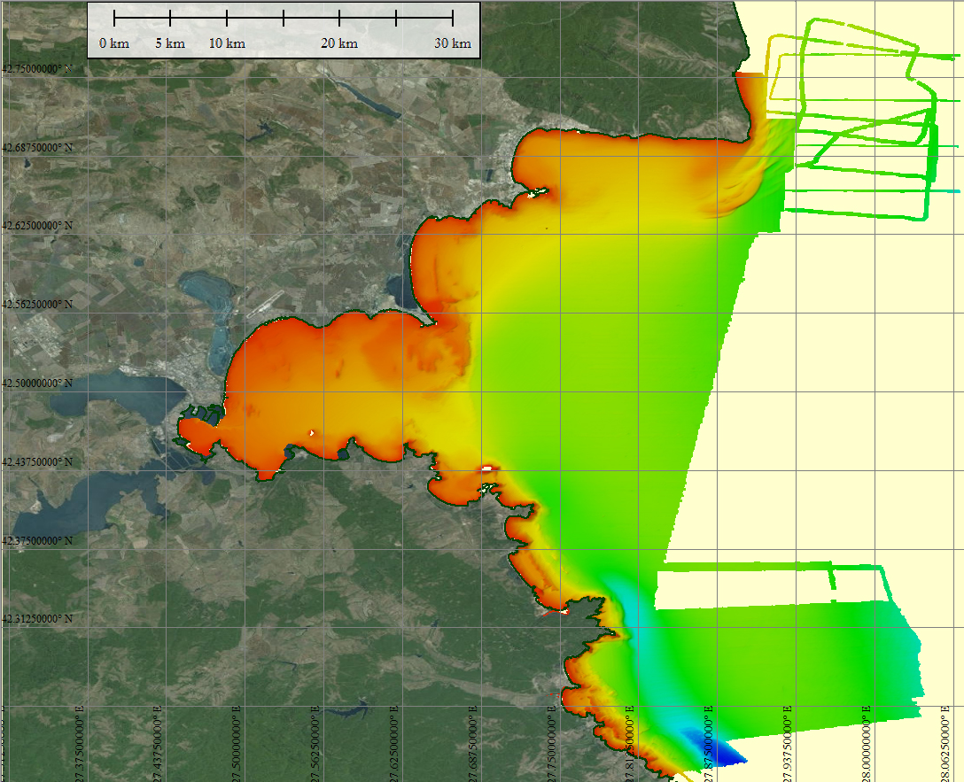
DTM of the Bulgarian Black Sea South Shore
The composite Digital Terrain Model of the Bulgarian Black Sea South Shore is the result of the processing of a compilation of single and multibeam echosounder data gathered by Institute of Oceanology – BAS, Varna, bathymetric LiDAR data, data from harbor authorities and of digitized chart contours produced before 1998. The DTM at a source resolution of approximately 54 meters was compiled for inclusion into the EMODnet hydrography dataset.
What
Metadata details
- File identifier
- SDN_CPRD_692_Bulgarian_Black_Sea_South_Shore
- Catalogue type
-
Composite Product Record
-
Project name
-
-
EMODNet Hydrography
-
EMODNet Bathymetry
-
- Dissemination level
-
public
- Metadata language
- English
- Date stamp
- 2022-09-21T07:11:37.319Z
Identification
- Dataset name
-
DTM of the Bulgarian Black Sea South Shore
- Short name of dataset (SDN Local Product-ID)
-
Bulgarian_Black_Sea_South_Shore
-
Parameter Discovery Vocabulary (P02)
-
-
Bathymetry and Elevation
-
-
SeaDataNet device categories
-
-
single-beam echosounders
-
multi-beam echosounders
-
-
SeaDataNet device categories
-
-
Differential Global Positioning System receivers
-
Geometry
- Spatial representation type
- Grid
- Number of columns
- 2468
- Number of lines
- 3352
- Pixel size
- 28 meter
- Maximum scale of use
- 50000
Abstract
- Dataset description abstract
-
The composite Digital Terrain Model of the Bulgarian Black Sea South Shore is the result of the processing of a compilation of single and multibeam echosounder data gathered by Institute of Oceanology – BAS, Varna, bathymetric LiDAR data, data from harbor authorities and of digitized chart contours produced before 1998. The DTM at a source resolution of approximately 54 meters was compiled for inclusion into the EMODnet hydrography dataset.
- Description of processed data sources
-
Description of processed data sources : Single and multibeam data were acquired under implementation of following Projects:
Expanding ecological network NATURA’2000 in the Bulgarian Black Sea (RV Akademik) funded by MEW’2011; Towards COast to COast NETworks of marine protected areas, coupled with sea-based wind energy potential - CoCoNet (FP7 Project # 287844) - RV Akademik and MB Walnobor-3 campaigns in 2013; – Monitoring Program – Hydrographic mapping of the Bulgarian Black Sea Water bodies (RV Akademik and MB Shelf) funded by MEW’2013; Black Sea Maritime Archeological Project, 2015 campaign; The bathymetric LiDAR data was obtained by CUWA under the Bulgarian Black Sea Bathymetric LiDAR’2011 Project;
- Description of data processing
-
Description of data processing : All data were processed by PDS2000 software up to creating of the DTM
- Processing software
-
PDS2000; Globe
Quality
Accuracy / Calibration
Hor. accuracy
- Measure description
-
Radius describing a circle, in which the true point location lies with the probability of 39.4%.
- Value
- 2
Vert. accuracy
- Measure description
-
10% of water depth or better
- Evaluation method description
-
Z Standard Deviation
Quality Indicators
- Horizontal Quality Indicator
- 3 - < 20 m
- Vertical Quality Indicator
- 4 - MBES High frequency (higher that 100kHz) (1+0.5%d)
- Purpose Quality Indicator
- 2 - Bathymetric/morphologic survey
Where
))
- Min. depth in meters (>0 below Sea Level)
- 0.0
- Max. depth in meters (>0 below Sea Level)
- 59.13
Projection
- code
-
WGS 84 (EPSG:4326)
- Version or custom projection details
-
7.4
When
Creation date
Revision date
Temporal extent*
Who
Originator
- Organisation name
-
Institute of Oceanology, Bulgarian Academy of Sciences (IO-BAS)
- Country
-
Bulgaria
Data Holding Center
- Country
-
Bulgaria
Collating Centre = Metadata author
- Organisation name
-
Institute of Oceanology, Bulgarian Academy of Sciences (IO-BAS)
- Country
-
Bulgaria
Access
Distributor
- Organisation name
-
Institute of Oceanology, Bulgarian Academy of Sciences (IO-BAS)
- Organisation name
-
Institute of Oceanology, Bulgarian Academy of Sciences (IO-BAS)
- Country
-
Bulgaria
Data formats*
- Format
-
NetCDF
- Version
-
1.5.11
- Transfer size (in MB)
- 26385
- OnLine resource
-
Protocol Linkage Name WWW:LINK
http://www.io-bas.bg WWW:DOWNLOAD-1.0-link--download
https://downloads.emodnet-bathymetry.eu/high_resolution/692_Bulgarian_Black_Sea_South_Shore.emo.zip WWW:LINK
https://tiles.emodnet-bathymetry.eu/ EMODnet Bathymetry WMTS service
WWW:LINK
https://emodnet.ec.europa.eu/geoviewer EMODnet viewer
Intellectual property
- Access constraints
- Creative Commons Attribution 4.0 International
- Use constraints
- Other restrictions
- Other constraints
-
DO NOT USE FOR NAVIGATION
)))