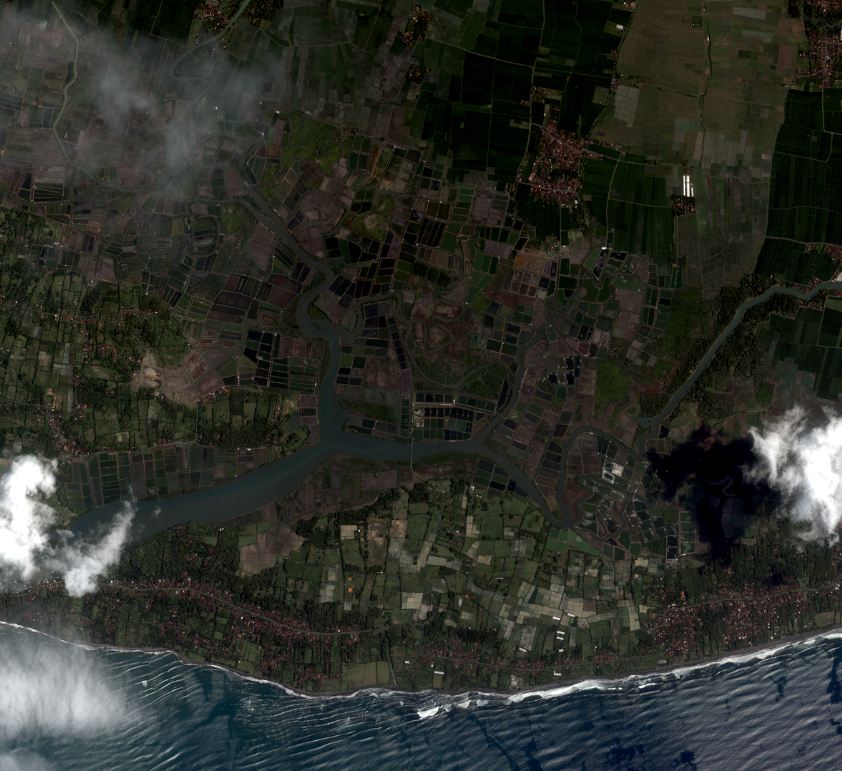
High resolution satellite imagery - Perancak- February 21st, 2003
Ikonos-2 satellite images from Perancak site acquired during the INDESO project on February 21st, 2003.
They are composed of 4 channels (infrared, red, green and blue) with a 4m spatial resolution and one panchromatic image with a 1m resolution.
A mosaicing and clipping treatment of all images available is provided in visualization. Each channel can be download for Indeso project partners.
Simple
- Title
-
High resolution satellite imagery - Perancak- February 21st, 2003
- Date (Publication)
- 2015-05-18
- Citation identifier
- IFR_NEW_CAL_INDESO_SAT_PERANCAK_21FEVR2003
- Presentation form
- Digital image
- Abstract
-
Ikonos-2 satellite images from Perancak site acquired during the INDESO project on February 21st, 2003.
They are composed of 4 channels (infrared, red, green and blue) with a 4m spatial resolution and one panchromatic image with a 1m resolution.
A mosaicing and clipping treatment of all images available is provided in visualization. Each channel can be download for Indeso project partners.
- Purpose
-
Dataset acquired during the Indeso project, for shrimp applications development of indicators for sustainable aquaculture in Indonesia and for mangrove application
- Credit
-
CLS
- Credit
-
Digital globe
- Credit
-
Balitbang
- Status
- Completed
- Point of contact
-
Organisation name Individual name Electronic mail address Role IRD - UMR AMAP
Christophe Proisy
Product manager Ifremer
Benoit Soulard
Production center Balitbang
Berny Subki
Owner
- Maintenance and update frequency
- Not planned
-
Thèmes Sextant
-
-
/Imagery/Satellite Imagery
-
-
GEMET - INSPIRE themes, version 1.0
-
-
Installations agricoles et aquacoles
-
- Place
-
-
Perancak
-
- Use limitation
-
Restricted use for Indeso project
- Access constraints
- License
- Use constraints
- Restricted
- Spatial representation type
- Grid
- Denominator
- 4500
- Language
- Français
- Character set
- UTF8
- Topic category
-
- Imagery base maps earth cover
))
- Begin date
- 2003-02-21
- End date
- 2003-02-21
- Reference system identifier
- EPSG / WGS 84 / UTM zone 50S (EPSG:32750) / 7.9
- Number of dimensions
- 2
- Dimension name
- Row
- Dimension size
- 4412
- Dimension name
- Column
- Dimension size
- 4784
- Cell geometry
- Area
- Transformation parameter availability
Distributor
- Distributor contact
-
Organisation name Individual name Electronic mail address Role Ifremer - Sextant
Administrateur du serveur Sextant
Production Unit
- Distributor format
-
Name Version TIFF
- Hierarchy level
- Dataset
Conformance result
- Title
-
Inspire specifications
- Date (Publication)
- 2015-05-18
- Explanation
-
Non évalué
- Pass
- Statement
-
Images provided by CLS:
Products references : po_1342986_0000000
Metadata
- File identifier
- 02b2b365-daf8-4421-91de-b63222c630c9
- Metadata language
- Français
- Other language
-
Language Character encoding English
- Character set
- UTF8
- Hierarchy level
- Dataset
- Date stamp
- 2020-06-04T01:08:53
- Metadata standard name
-
ISO 19115:2003/19139 - SEXTANT
- Metadata standard version
-
1.0
- Metadata author
-
Organisation name Individual name Electronic mail address Role Ifremer
Benoit Soulard
Author
accessData
Overviews
)))