Fishing effort | Fishing_Effort | The International Council for the Exploration of the Sea | 26092017_ExtractionVMS_UK_AND_EST
Simple
Identification info
- Alternate title
-
26092017_ExtractionVMS_UK_AND_EST
- Date
- Citation identifier
- Fishing effort | Fishing_Effort | The International Council for the Exploration of the Sea | 26092017_ExtractionVMS_UK_AND_EST
- Convention
-
Individual Country Vessels anonymized and Agregated submission (input data in untreated form delivered to ICES)
- Purpose
-
VMS/Logbook data for fishing activities in the North East Atlantic for the provision of ICES management advice on spatial distribution and impact of fisheries 2009-2016
- Status
- On going
- Point of contact
-
Organisation Individual Electronic mail address ORCID Role Working Group on Spatial Fisheries Data
WGSFD
edmerp The International Council for the Exploration of the Sea
edmo
- Spatial representation type
- Vector
Spatial resolution
- Spatial resolution
- 3000 meter
- Topic category
-
- Oceans
Extent
))
Extent
- Time period
- 2009 2016
- Maintenance and update frequency
- Unknown
- Used by challenges
-
-
Atlantic - CH07 - Fisheries Impact
-
- Environmental matrix
-
-
Human activities
-
- Production mode
-
-
Delayed
-
- Visibility
-
-
Information retrieved upon specific request to the data source
-
- Policy visibility
-
-
There is information, but details are available only on request
-
- Readyness
-
-
Format proprietary but content clearly specified
-
- Parameter Discovery Vocabulary (P02)
-
-
Fishing effort
-
- GEMET - INSPIRE themes, version 1.0
-
-
Sea regions
-
- Processing level of characteristics
-
-
High level analyzed
-
- Data delivery mechanisms
-
-
Manual process: Order form/invoice is requested
-
- Parameter Usage Vocabulary (other)
-
-
Fishing_Effort
-
- Agreed Parameter Groups (P03)
-
-
Human activity
-
- Service extent
-
-
Data sets are not referenced in a catalogue or are referenced in a non public catalogue
-
- Validation
-
-
Draft
-
Resource constraints
- Access constraints
- Other restrictions
- Other constraints
-
Restricted
Resource constraints
- Use limitation
-
N\A
- Language
- Français
- Character encoding
- UTF8
- Environment description
-
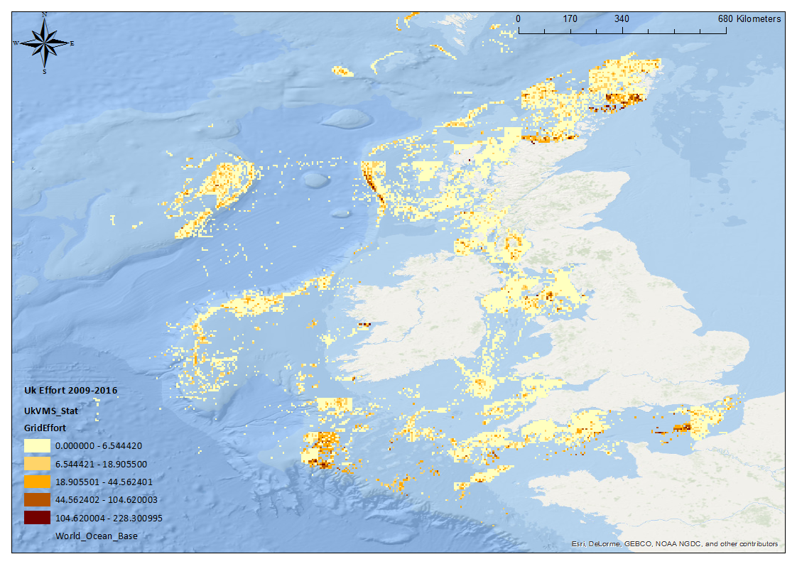
This data set describes the fishing effort by the UK fishing fleet in the NE Atlantic Ocean from 2009 - 2016. the output data associated with this data set is P1_TotalEffort2009-2016, which maps the monthly effort per year.
Content Information
- Attribute description
- observation
- Content type
- Physical measurement
ATLANTIC_CH07_Product_1 / Area where bottom habitat has been disturbed by bottom trawling (number of disturbances per month)
))
- Begin date
- 2009
- End date
- 2016After
Vertical element
- Minimum value
- 0
- Maximum value
- 1000
Resource lineage
- Hierarchy level
- Dataset
Spatial representation info
- Dimension name
- Time
- Resolution
- 1 month
- Cell geometry
- Transformation parameter availability
- true
- Check point availability
- true
Metadata
- Metadata identifier
- urn:uuid/081005d7-2b2e-47f5-b972-b638fb4bcada
- Language
- English
- Character encoding
- UTF8
- Contact
-
Organisation Individual Electronic mail address ORCID Role Marine Institute
Type of resource
- Resource type
- Dataset
- Name
-
Atlantic - CH07 - Fisheries Impact
- Metadata linkage
-
https://sextant.ifremer.fr/geonetwork/srv/eng//metadata/081005d7-2b2e-47f5-b972-b638fb4bcada
- Date info (Revision)
- 2019-05-28T14:21:35Z
- Date info (Released)
- 2018-01-29T18:04:00
- Date info (Creation)
- 2014-10-08T14:35:32
Metadata standard
- Title
-
ISO 19115-3 - Emodnet Checkpoint - Upstream Data
- Edition
-
1.0
Individual Country Vessels anonymized and Agregated submission (input data in untreated form delivered to ICES)
accessData
Overviews
Spatial extent
)))