Tide Current Atlas – English Channel - Atlantic
Tide current atlas
Simple
- Title
-
Tide Current Atlas – English Channel - Atlantic
- Date (Creation)
- 1988-01-01T00:00:00
- Citation identifier
- FR-DCSMM-PDS-BD_ATLAS_COURANT
- Presentation form
- Digital profile
- Abstract
-
Tide current atlas
- Purpose
-
Tide current products in the form of digital and paper atlases drawn up by the SHOM can be used to visualize the predictive component of current fields, connected to tides, at each hour of the tide, at average spring tides and neap tides for the French Atlantic and Channel coasts. The knowledge of tides, currents, bathymetry, and the expertise in hydrodynamic modelling which the SHOM have, makes it possible to describe the currents in a given area in detail. These atlases provide a “snapshot” of predictive tide currents and are set against the current observation data which are carried out regularly (for example, see file PNH). These atlases are a benchmark in their given area. They are updated according to continuing improvements in knowledge (new measurements) or calculated as they are needed (zooms are possible in areas of particular interest). The tide atlas currents were originally designed to meet navigation, diving and fishing needs, but they are also crucial entry-level data within the context of environmental studies:
for investigations into dumping at sea or harbour planning for example.
- Credit
-
Data producer : SHOM
- Status
- On going
- Point of contact
-
Organisation name Individual name Electronic mail address Role SHOM
DESMARE Stéphanie
Local service desk SHOM
WEBER Nicolas
Author
- Maintenance and update frequency
- As needed
- Maintenance note
-
Network duration : perennial network
- Theme
-
-
Atlas
-
Tide current
-
Coastal hydrodynamics
-
-
GEMET - INSPIRE themes, version 1.0
-
-
Environmental monitoring facilities
-
-
Sous-regions marines
-
-
Bay of Biscay
-
Channel-North Sea
-
Celtic Seas
-
-
DCSMM : Type d'espace concerné
-
-
Pas d'espace particulier concerné
-
-
DCSMM : Descripteurs
-
-
D7: Hydrographical Conditions
-
-
DCSMM : Méthodes de recueil des données
-
-
Observation par point
-
-
Thèmes Sextant
-
-
/Physical Environment/Hydrodynamics/Currents
-
- Access constraints
- Other restrictions
- Other legal constraints
-
Restricted access
A SHOME copyright licence and a fee for the format requested (paper atlas, CDROM), or for access to the data.
- Use limitation
-
Tide current data is available in the form of printed atlases or digital files.
Tide current atlases are available from designated SHOM retailers, a list of which can be found on the SHOM website.
For digital files, the SHOM offers licences for the data to be used for non-commercial and internal purposes.
- Spatial representation type
- Vector
- Denominator
- 50000
- Language
- Français
- Character set
- UTF8
- Topic category
-
- Oceans
))
- Supplemental Information
-
Project leader :
SHOM 1988
Prime contractor :
SHOM 1988
Backer :
SHOM
- Reference system identifier
- EPSG / WGS 84 (EPSG:4326) / 7.9
- Topology level
- Geometry only
- Geometric object type
- Complex
- Geometric object count
- 0
- Hierarchy level
- Dataset
Conformance result
- Title
-
Inspire specifications
- Date (Creation)
- 2012-01-16
- Explanation
-
Non assessed
- Pass
- Statement
-
1988 : First atlas made using a digital model (Pas de Calais region)
1994 : Use of the TELEMAC modelling tool developed by EDF-SOGREAH to create current atlases
1994-2005 : Subsequent atlas editions
2009 : Updating process begun
Number of observation or measurement points : up to 700 points / zone
These products are created from "tide current models” which are calculated and validated in advance by coastal hydrodynamics experts. These models with completed elements (no triangle mesh) are currently generated using the TELEMAC 2D software (developed by the Saint-Venant – EDF laboratory).
Modelling requires detailed knowledge of bathymetry and open-limit conditions (water level and/or currents). For the models which were used to create the atlas, the entry level data typically comes from the national databases managed by the SHOM.
The accuracy of tide current values from the models has been evaluated by comparing it with reliable measurements, attributing an average accuracy to each model.
The changes in calculation averages and improvements in hydrographic knowledge (bathymetry, tides, currents, etc.) can be used to obtain more accurate results for higher spatial resolution.
- Description
-
Data type : Coastal hydrodynamics Précision sur le type de donnée : Atlas
Measured or observed parameters : tide currents
Parameters resolution :
Condition : for two typical tide coefficients (45 and 95)
Temporal resolution : Condition : for two typical tide coefficients (45 and 95)
Temporal resolution : 13 h (hour by hour from 6h prior to, to 6h after high tide (PM) or low tide (BM) at a specific port of reference.
Spatial Resolution : regular mesh, varying according to the area from 500m to 7 km
Update frequency : Updated according to updates in the data on which the models are based
Observation frequency : Hourly
- Description
-
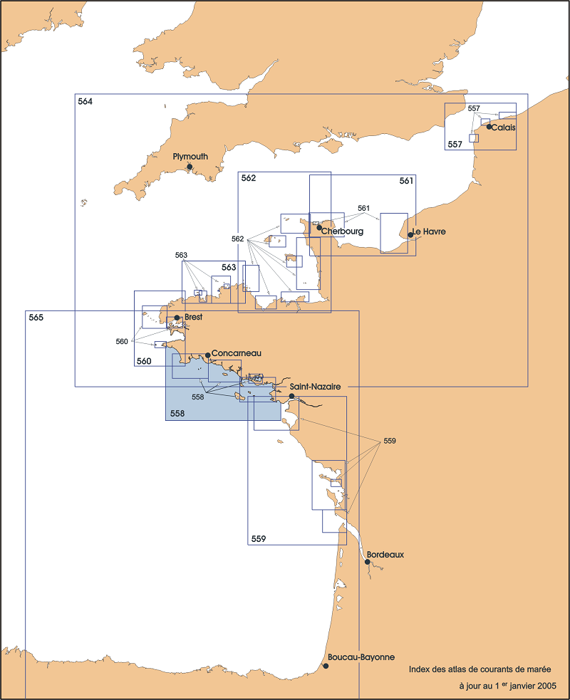
Paper tide current atlases :
1988 557-UJA Pas de Calais
2005 558-UJA Coast of Southern Brittany (Audierne to Croisic) 2001 559-UJA Coast of Western France (Saint-Nazaire to Royan)
1994 560-UJA Coast of Western Brittany (Goulven to Penmarc'h) 1996 561-UJA Bay of the Seine (Cherbourg to Fécamp)
1998 562-UJA Golf of Normandy – Brittany (Cherbourg to Paimpol)
1999 563-UJA Coast of Northern Brittany (Héaux-de-Bréhat to the Pointe de Pontusval)
2000 564-UJA English Channel (Dunkirk to Brest) 2002 565-UJA Bay of Biscay
- Description
-
Sampling method : Spatial
- Description
-
Associated information : BD Courants, Courants 3D
Metadata
- File identifier
- 0b5b0807-9ce2-46e5-a831-3aba7065247d
- Metadata language
- Français
- Other language
-
Language Character encoding English
- Character set
- UTF8
- Hierarchy level
- Series
- Date stamp
- 2020-06-04T00:22:52
- Metadata standard name
-
ISO 19115:2003/19139 - SEXTANT
- Metadata standard version
-
1.0
- Metadata author
-
Organisation name Individual name Electronic mail address Role Sextant
Local service desk
accessData
Overviews
)))