Species and habitats - Fish communities of the Eastern English Channel
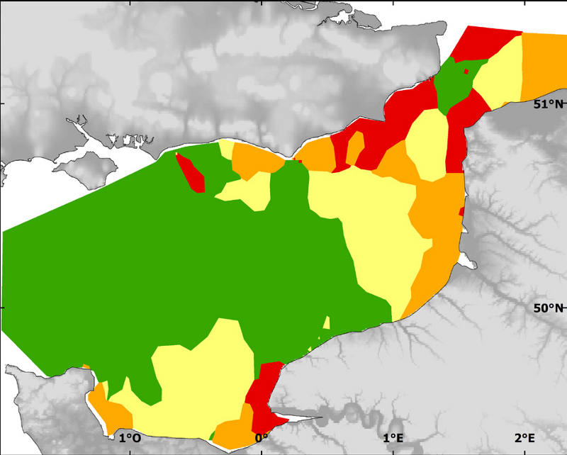
Community types classified by TWINSPAN and mapped by combined indicator kriggings. Target community: 79 species of fish, 2 cephalopods and 3 macro-benthic species
Biologic data have been expressed in abundance (Number of individuals per km²). Community classes were obtained from TWINSPAN analysis. Community classes distribution was obtained by combining probability maps of belonging to each class.
Simple
- Title
-
Species and habitats - Fish communities of the Eastern English Channel
- Alternate title
-
CGFS_general_geostatS
- Alternate title
-
CHARM_FISH_COMMUNITIES_P
- Date (Publication)
- 2009-12-31T00:00:00
- Citation identifier
- CHARM_FISH_COMMUNITIES_P
- Presentation form
- Digital map
- Other citation details
-
Source CHARM Consortium
- Abstract
-
Community types classified by TWINSPAN and mapped by combined indicator kriggings. Target community: 79 species of fish, 2 cephalopods and 3 macro-benthic species
Biologic data have been expressed in abundance (Number of individuals per km²). Community classes were obtained from TWINSPAN analysis. Community classes distribution was obtained by combining probability maps of belonging to each class.
- Credit
-
Ifremer
- Credit
-
CHARM Consortium
- Status
- Completed
- Point of contact
-
Organisation name Individual name Electronic mail address Role CHARM Consortium
CHARM Consortium
Production center IFREMER
Coppin Franck
Local service desk
- Maintenance and update frequency
- As needed
-
Thèmes Sextant
-
-
/Biological Environment/Species/Fish Species of Commercial Interest
-
- Theme
-
-
Species data set
-
CHARM
-
-
GEMET - INSPIRE themes, version 1.0
-
-
Habitats and biotopes
-
-
external.theme.gemet
-
-
communauté écologique
-
-
Sous-regions marines
-
-
Channel-North Sea
-
- Use limitation
-
research-only
- Access constraints
- License
- Other legal constraints
-
Has to be cited this way in maps : "Source CHARM Consortium"
- Other legal constraints
-
Has to be cited this way in bibliography : "Vaz Sandrine, Carpentier Andre, Coppin Franck (2007). Eastern English Channel fish assemblages: measuring the structuring effect of habitats on distinct sub-communities. ICES Journal of Marine Science, 64(2), 271-287. Publisher's official version : http://dx.doi.org/10.1093/icesjms/fsl031 , Open Access version : http://archimer.ifremer.fr/doc/00000/2829/"
- Spatial representation type
- Vector
- Denominator
- 10000
- Language
- Français
- Language
- English
- Character set
- UTF8
- Topic category
-
- Biota
- Oceans
- Environment
- Environment description
-
Microsoft Windows XP ; ESRI ArcGIS 9.x
- Geographic identifier
- Eastern English Channel
))
- Begin date
- 1988-01-01
- End date
- 2004-12-31
- Reference system identifier
- 4326
- Topology level
- Geometry only
- Geometric object type
- Surface
- Geometric object count
- 34
Distributor
- Distributor contact
-
Organisation name Individual name Electronic mail address Role Ifremer - Centre de Brest
- Distributor format
-
Name Version
- OnLine resource
-
Protocol Linkage Name WWW:LINK
http://www.ifremer.fr/charm/ OGC:WMS
https://sextant.ifremer.fr/services/wms/wms_charm? CHARM_FISH_COMMUNITIES_P
FILE
CHARM_FISH_COMMUNITIES_P
- Hierarchy level
- Dataset
- Statement
-
The classification of the communities was based on data from the CGFS survey (1988-2004). It comprises a total of 79 fish species, two cephalopods and three macro-invertebrate benthic species.
- Description
-
This classification was obtained using the TWINSPAN method, a method allying ordination and dichotomous classification. It is a hierarchical divisive algorithm based on a Detrended Correspondence Analysis (DCA) of the original (site x species) data matrix, which attempts to summarise the major trends in the data.This classification consists of four sub-communities (classes 1 to 4). Each class is characterised by indicator species, i.e. which have a statistical weight in the discrimination of a given sub-community and by and preferential species, i.e. having a strong affinity for a given sub-community, both in occurrence frequency and abundance.The spatial distribution of the sub-communities hence defined was then obtained using indicator kriging of each community type. This interpolation technique is adapted to nominal variables and allows the production of a map giving the occurrence probability of the community type at any given location. The distribution map for the four types were then combined, choosing at each location the community type displaying the highest occurrence probability.
- Description
-
CGFS, annual scientific survey of IFREMER
Metadata
- File identifier
- 0becaee0-01f9-11e0-9e8f-005056987263
- Metadata language
- English
- Character set
- UTF8
- Hierarchy level
- Dataset
- Date stamp
- 2020-06-04T01:14:08
- Metadata standard name
-
ISO 19115:2003/19139 - SEXTANT
- Metadata standard version
-
1.0
- Metadata author
-
Organisation name Individual name Electronic mail address Role Ifremer
Sandrine Vaz
Local service desk
accessData
Overviews
)))