Bathymetry and Elevation | BATHDPTH | Bulgarian Oceanographic Data Centre, Institute of Oceanology - Bulgarian Academy of Sciences | Heavy-traffic_areas_Black_and_Azov_seas
Simple
Identification info
- Alternate title
-
Heavy-traffic_areas_Black_and_Azov_seas
- Date
- Citation identifier
- Bathymetry and Elevation | BATHDPTH | Bulgarian Oceanographic Data Centre, Institute of Oceanology - Bulgarian Academy of Sciences | Heavy-traffic_areas_Black_and_Azov_seas
- Convention
-
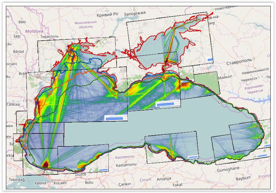
Heavy-traffic marine areas in the Black and Azov seas
- Purpose
-
Black Sea and Sea of Azov: visualization of marine areas with heavy vessel traffic
- Status
- On going
- Point of contact
-
Organisation Individual Electronic mail address ORCID Role Marine Traffic: Global Ship Traffic Intelligence
AIS Marine Traffic
edmerp Bulgarian Oceanographic Data Centre, Institute of Oceanology - Bulgarian Academy of Sciences
edmo AIS Marine Traffic
Originator
- Spatial representation type
- Vector
Spatial resolution
- Spatial resolution
- 100 meter
- Topic category
-
- Oceans
Extent
))
Extent
- Time period
- 9999
Vertical element
- Minimum value
- 0
- Maximum value
- 50
- Maintenance and update frequency
- As needed
- Used by challenges
-
-
BlackSea - CH10 - Bathymetry
-
- Environmental matrix
-
-
Seabed - Riverbed
-
- Production mode
-
-
Delayed
-
- Visibility
-
-
Information retrieved upon specific request to the data source
-
- Policy visibility
-
-
There is no information at all on data policy adopted by data providers
-
- Parameter Discovery Vocabulary (P02)
-
-
Bathymetry and Elevation
-
- GEMET - INSPIRE themes, version 1.0
-
-
Hydrography
-
- Processing level of characteristics
-
-
High level analyzed
-
- Data delivery mechanisms
-
-
No information was found on data delivery mechanisms
-
- Parameter Usage Vocabulary (other)
-
-
BATHDPTH
-
- Agreed Parameter Groups (P03)
-
-
Gravity, magnetics and bathymetry
-
- Service extent
-
-
Data sets are not referenced in a catalogue or are referenced in a non public catalogue
-
- Validation
-
-
Draft
-
Resource constraints
- Access constraints
- Other restrictions
- Other constraints
-
Unrestricted
Resource constraints
- Use limitation
-
Not or not well documented
- Language
- Français
- Character encoding
- UTF8
- Environment description
-
A dataset consisting of 13 georeferenced screenshots with 100 m pixel size each showing the areas with heavy marine traffic in the Black Sea and the Sea of Azov. The mosaic subsequently used for digitalization in GIS of priority areas for bathymetric surveys in the future in order to secure basin-scale safe navigation
Content Information
- Attribute description
- observation
- Content type
- Physical measurement
Distribution Information
- Distribution format
-
-
IMAGINE raster file (.IMG)
-
BLACKSEA_CH10_Product_3 / Priority areas for surveying for safer navigation (wrt to heavy maritime traffic)
))
- Begin date
- 2015-01-01T00:00:00
- End date
- 2017-12-31T00:00:00 After
Vertical element
- Minimum value
- 0
- Maximum value
- 50
BLACKSEA_CH10_Product_3 / Priority areas for surveying for safer navigation (wrt to heavy maritime traffic)
- Begin date
- 2015-01-01T00:00:00
- End date
- 2017-12-31T00:00:00 After
Vertical element
- Minimum value
- 0
- Maximum value
- 50
Resource lineage
- Statement
- Hierarchy level
- Dataset
Spatial representation info
- Number of dimensions
- 1
- Axis dimension properties
-
Dimension name Dimension size Resolution Time
- Cell geometry
- Transformation parameter availability
- true
- Check point availability
- true
Metadata
- Metadata identifier
- urn:uuid/0cc4abde-ae58-4b9e-8a2f-62f384678179
- Language
- English
- Character encoding
- UTF8
- Contact
-
Organisation Individual Electronic mail address ORCID Role Prof. Fridtjof Nansen Institute of Oceanology - Bulgarian Academy of Sciences
Type of resource
- Resource type
- Dataset
- Name
-
BlackSea - CH10 - Bathymetry
- Metadata linkage
-
https://sextant.ifremer.fr/geonetwork/srv/eng//metadata/0cc4abde-ae58-4b9e-8a2f-62f384678179
- Date info (Revision)
- 2018-01-24T14:44:56Z
- Date info (Creation)
- 2017-12-18T13:12:27
- Date info (Creation)
- 2014-10-08T14:35:32
Metadata standard
- Title
-
ISO 19115-3 - Emodnet Checkpoint - Upstream Data
- Edition
-
1.0
Heavy-traffic marine areas in the Black and Azov seas
accessData
Overviews
Spatial extent
)))