Mapping of marine biocenoses between Antibes and Cap d'Ail
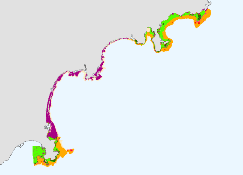
This mapping of marine biocenoses between 0 and 50m depth covers 75km of coastline between Antibes and Cap d'Ail.
Simple
- Title
-
Mapping of marine biocenoses between Antibes and Cap d'Ail
- Alternate title
-
BIOMED_BIOC_ANTIBE_P
- Date (Publication)
- 2007-07-01T00:00:00
- Citation identifier
- BIOMED_BIOC_ANTIBE_P
- Presentation form
- Digital map
- Abstract
-
This mapping of marine biocenoses between 0 and 50m depth covers 75km of coastline between Antibes and Cap d'Ail.
- Purpose
-
Mapping marine biological communities between Antibes and Cap d'Ail is part of the fulfillment of the contract for the bay. Sponsored by CANCA, it was performed by L'Oeil d'Andromède from April 2006 to May 2007, with the financial support of the Agence de l'Eau RM & C (Water Agency), the PACA region and the General Council of the Alpes Maritimes.
This mapping has allowed an analysis of the vulnerability of biological communities and offers, ultimately, a series of actions necessary for their protection, enhancement and if necessary their restoration.
- Credit
-
Medbenth
- Status
- On going
- Point of contact
-
Organisation name Individual name Electronic mail address Role Communauté d'agglomération Nice Côte d'Azur
Jean François FABRE
Local service desk Agence de l'Eau RMC
Pierre BOISSERY
Local service desk Ifremer
Corinne TOMASINO
Local service desk
- Maintenance and update frequency
- As needed
-
Thèmes Sextant
-
-
/Biological Environment/Habitats
-
- Theme
-
-
biocénoses
-
habitat
-
posidonie
-
carte
-
- Place
-
-
Méditerranée
-
Antibes
-
Cap d'Ail
-
-
GEMET - INSPIRE themes, version 1.0
-
-
Habitats and biotopes
-
-
Cadre Réglementaire - SIMM
-
-
Directive Cadre pour la Planification de l'Espace Maritime (DCPEM)
-
Directive Cadre Stratégie pour le Milieu Marin (DCSMM)
-
-
Thématiques - SIMM
-
-
/Etat du Milieu/Habitats
-
-
Sous-regions marines
-
-
Western Mediterranean
-
- Use limitation
-
Ce produit numérique a été élaboré dans le cadre de la réalisation d'une synthèse des travaux cartographiques traitant des biocénoses benthiques et disponibles en Méditerranée. Ce travail a été réalisé en partenariat par l'Agence de l'eau Rhône Méditerranée & Corse et l'Ifremer. Les fichiers sont à usage personnel. Toute utilisation commerciale est strictement interdite.
- Access constraints
- Copyright
- Use constraints
- License
- Other legal constraints
-
Obligation de citation sur la carte: Communauté d'Agglomération Nice Côte d'Azur, Conseil Général des Alpes-Maritimes, Région PACA, Agence de l'Eau Rhône Méditerranée & Corse, Andromède Environnement
- Other legal constraints
-
Obligation decitation dans la bibliographie: HOLON F., DESCAMP P., 2007. CARTOGRAPHIE ET ANALYSE DES BIOCENOSES MARINES ENTRE ANTIBES ET CAP D'AIL. Contrat Communauté d'Agglomération Nice-Côte d'Azur.
- Spatial representation type
- Vector
- Denominator
- 5000
- Language
- Français
- Character set
- UTF8
- Topic category
-
- Oceans
- Environment
))
- Supplemental Information
-
The cartographic atlas exposes a coastline marked by the proximity of the Alps and has a varied profile of low-lying coasts and rocky coastlines that plunge directly into the sea. At sea we find this complex geomorphology resulting in a wide biocenotic variety concentrated in a small surface due to a narrow shelf. Seven rivers, including the Var, pour into the area and have a strong influence on marine ecological balances, for example, large amounts of new sediment supply during rain.
Several methods of data collection were used: a bibliographic synthesis of existing data, the use of multibeam and sidescan, a mapping of mediolittoral algae, the study of aerial photographs (IGN 1999 and 2004), and field verification campaigns by transect audio diver and periodic dives.
The reference used as coastline is the aerial photographs of IGN.
HOLON F., DESCAMP P., 2007. CARTOGRAPHIE ET ANALYSE DES BIOCENOSES MARINES ENTRE ANTIBES ET CAP D'AIL. Contract with the community of Nice-Côte d'Azur.
- Reference system identifier
- 4326
- Topology level
- Geometry only
- Geometric object type
- Surface
Distributor
- Distributor contact
-
Organisation name Individual name Electronic mail address Role Ifremer
Dissemination Unit
- Distributor format
-
Name Version
- OnLine resource
-
Protocol Linkage Name OGC:WMS
https://sextant.ifremer.fr/services/wms/biologie? BIOMED_BIOC_ANTIBE_P
- Hierarchy level
- Dataset
- Statement
-
HOLON F., DESCAMP P., 2007. CARTOGRAPHIE ET ANALYSE DES BIOCENOSES MARINES ENTRE ANTIBES ET CAP D'AIL. Contract with the community of Nice-Côte d'Azur.
Metadata
- File identifier
- 0e7a5090-57bf-11dd-a60f-000086f6a603
- Metadata language
- Français
- Other language
-
Language Character encoding English
- Character set
- UTF8
- Hierarchy level
- Dataset
- Date stamp
- 2020-06-04T00:46:25
- Metadata standard name
-
ISO 19115:2003/19139 - SEXTANT
- Metadata standard version
-
1.0
- Metadata author
-
Organisation name Individual name Electronic mail address Role Ifremer
Local service desk
accessData
Overviews
)))