Inventory of wild Pacific oyster (Crassostrea gigas) deposits on the coasts of the Pertuis Charentais. Environmental state for 2010-2012
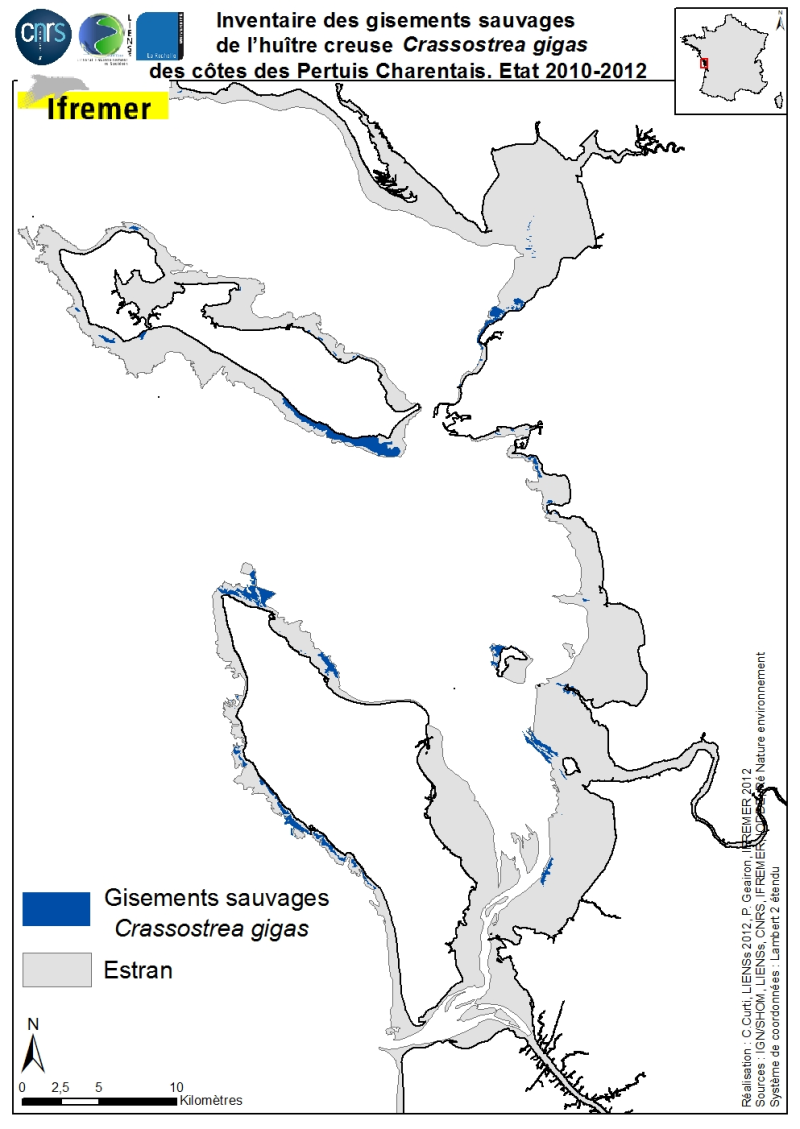
The geographical distribution of the main sources of wild Pacific oysters (Crassostrea gigas) (Thunberg, 1793) on the coasts of the Pertuis Charentais was compiled from 2010 to 2012. The inventory focuses on natural foreshore deposits (+ 6-0 m sea coast) and compiles two cartographic sources: 1) quantitative inventories made in 2010 by Ifremer from the Tranche sur Mer (Vendée) to Vaux-sur-Mer in 21 representative sites to estimate wild stocks of Pacific oysters and 2) inventory mapping of intertidal marine habitats mainly made by LIENSs (in cooperation with CREOCEAN, IODDE, Ré Nature Environnement and GEO-Transfert) under the project CARTHAM Natura 2000at sea of the Agency of Marine Protected Areas.
Methodologies used by Ifremer to estimate the areas colonized combine thematic analysis in Geographic Information System (GIS) and field validations (Soletchnik et al., 2012). The methodologies used to estimate LIENSs extension of the intertidal habitat of the oysters combined aerial image analysis, remote sensing, field validations and thematic analysis using GIS (Cajeri et al., 2012).
Simple
- Title
-
Inventory of wild Pacific oyster (Crassostrea gigas) deposits on the coasts of the Pertuis Charentais. Environmental state for 2010-2012
- Date (Creation)
- 2012-09-30T15:07:00
- Citation identifier
- FR-330-715-368-00198-ifr-MOL-CRASGIG-PERTUIS
- Abstract
-
The geographical distribution of the main sources of wild Pacific oysters (Crassostrea gigas) (Thunberg, 1793) on the coasts of the Pertuis Charentais was compiled from 2010 to 2012. The inventory focuses on natural foreshore deposits (+ 6-0 m sea coast) and compiles two cartographic sources: 1) quantitative inventories made in 2010 by Ifremer from the Tranche sur Mer (Vendée) to Vaux-sur-Mer in 21 representative sites to estimate wild stocks of Pacific oysters and 2) inventory mapping of intertidal marine habitats mainly made by LIENSs (in cooperation with CREOCEAN, IODDE, Ré Nature Environnement and GEO-Transfert) under the project CARTHAM Natura 2000at sea of the Agency of Marine Protected Areas.
Methodologies used by Ifremer to estimate the areas colonized combine thematic analysis in Geographic Information System (GIS) and field validations (Soletchnik et al., 2012). The methodologies used to estimate LIENSs extension of the intertidal habitat of the oysters combined aerial image analysis, remote sensing, field validations and thematic analysis using GIS (Cajeri et al., 2012).
- Purpose
-
This shapefile was created for the purpose of an specific inventory map of main sources of oyster Crassostrea gigas in the Pertuis Charentais. It is part of an updated inventory of edible molluscs of the coast of Lower Charente and south Vendée as carried out in 1904-1907 by Guérin-Ganivet.
- Credit
-
Ifremer La Tremblade : Ph. Geairon, digitalisation et P. Soletchnik, O. Le Moine et S. Robert, validation biologique. LIENSs-CNRS-Université de la Rochelle : C. Curti, digitalisation, P. Cajeri et P.-G. Sauriau, validation biologique.
- Status
- On going
- Point of contact
-
Organisation name Individual name Electronic mail address Role IFREMER, LIENSs (CNRS, Université de La Rochelle)
Product manager Ifremer LIENSs
P. Soletchnik, Ph. Geairon, O. Le Moine, S. Robert, C. Curti, P. Cajeri & P.-G. Sauriau
Author Ifremer
Sextant
Dissemination Unit Ifremer
Publisher Lienss
C. Curti
Processor Ifremer, LIENSs, CREOCEAN, IODDE, Ré Nature Environnement, Géo Transfert
Production Unit Ifremer
P. Soletchnik
Production center LIENSs, CNRS, Université de la Rochelle
P.-G. Sauriau
Production center Ifremer LIENSs
P. Soletchnik P.-G. Sauriau
Local service desk Ifremer LIENSs
P. Soletchnik P.-G. Sauriau
Principal investigator Ifremer/CNRS/Université de La Rochelle
Owner Ifremer/AAMP/INPN/CNRS/ULR/DREALPC/AELB/AEAG
User
- Maintenance and update frequency
- As needed
-
Thèmes Sextant
-
-
/Biological Environment/Species/Fish Species of Commercial Interest
-
- Discipline
-
-
Biology, benthos, marine culture, Crassostrea gigas
-
- Place
-
-
Pertuis Charentais Sea
-
- Stratum
-
-
0 to +6 m CM
-
- Temporal
-
-
2010-2012
-
- Theme
-
-
Biology, fauna, species distribution
-
-
GEMET - INSPIRE themes, version 1.0
-
-
Habitats and biotopes
-
-
Type de jeux de donnée ODATIS
-
-
/Processed data/Composite products
-
-
Thématiques - SIMM
-
-
/Etat du Milieu/Habitats
-
-
Sous-regions marines
-
-
Bay of Biscay
-
- Use limitation
-
This file is for personal use and not commercial. For any purpose other than personal, please contact the distributor. Any modification of this data is subject to prior authorization. To do so, please contact the administrator of the data.
- Access constraints
- Other restrictions
- Use constraints
- Copyright
- Other legal constraints
-
Required citation for the map : « Sources : Ifremer, LIENSs, CREOCEAN, IODDE, Ré Nature Environnement, GEO-Transfert. Réalisation : C. Curti, 2012 ; produit numérique Ifremer/ LIENSs / CNRS / Université de la Rochelle »
- Other legal constraints
-
Required citation for the bibliography Cajeri P., Curti C., Lafon V., Launay R. & Sauriau P.-G. (2012). Cartographie des habitats intertidaux des sites Natura 2000 des Pertuis charentais : complémentarité des approches inventaire terrain, télédétection et SIG. In: Actes des XIIèmes Journées Nationales Génie Côtier – Génie Civil. D. Levachez, Sanchez M. & Guillou S., (eds), Cherbourg : pp. 855-864. Soletchnik P., Geairon P., Le Moine O. & Robert S. (2012). Estimation des stocks sauvages d'huîtres creuses dans les pertuis charentais en 2010. Ifremer, La Tremblade, Rapport Interne, ODE / LER / LERPC 2012 : 33 pp.
- Spatial representation type
- Vector
- Denominator
- 300000
- Language
- Français
- Character set
- UTF8
- Topic category
-
- Biota
- Environment description
-
Digitalisation des polygones sous ArcGis à partir de vérités terrain et photographies aériennes.
- Begin date
- 2012-09-24T15:24:00
- End date
- 2012-09-24T15:24:00
))
- Reference system identifier
- EPSG / WGS 84 (EPSG:4326) / 7.4
- Topology level
- Geometry only
- Geometric object type
- Surface
- Geometric object count
- 111
- Distribution format
-
Name Version shp
10
- OnLine resource
-
Protocol Linkage Name WWW:LINK
sextant@ifremer.fr
- Hierarchy level
- Attribute
Conformance result
- Title
-
Inspire specifications
- Date (Creation)
- 2012-01-16
- Explanation
-
not evaluated
- Pass
- Statement
-
This map comes from cartography carried out by Ifremer and LIENSs in GIS projects of national and regional research.
Metadata
- File identifier
- 111ffbf6-e4bf-4f16-9a8e-a0c1d1c67224
- Metadata language
- Français
- Other language
-
Language Character encoding English
- Character set
- UTF8
- Hierarchy level
- Dataset
- Date stamp
- 2020-06-04T00:24:56
- Metadata standard name
-
ISO 19115:2003/19139 - SEXTANT
- Metadata standard version
-
1.0
- Metadata author
-
Organisation name Individual name Electronic mail address Role Lienss CNRS Universite de la Rochelle
C. CURTI
Local service desk
accessData
Overviews
)))