Planning units layers used in ATLAS spatial prioritization on the North Atlantic
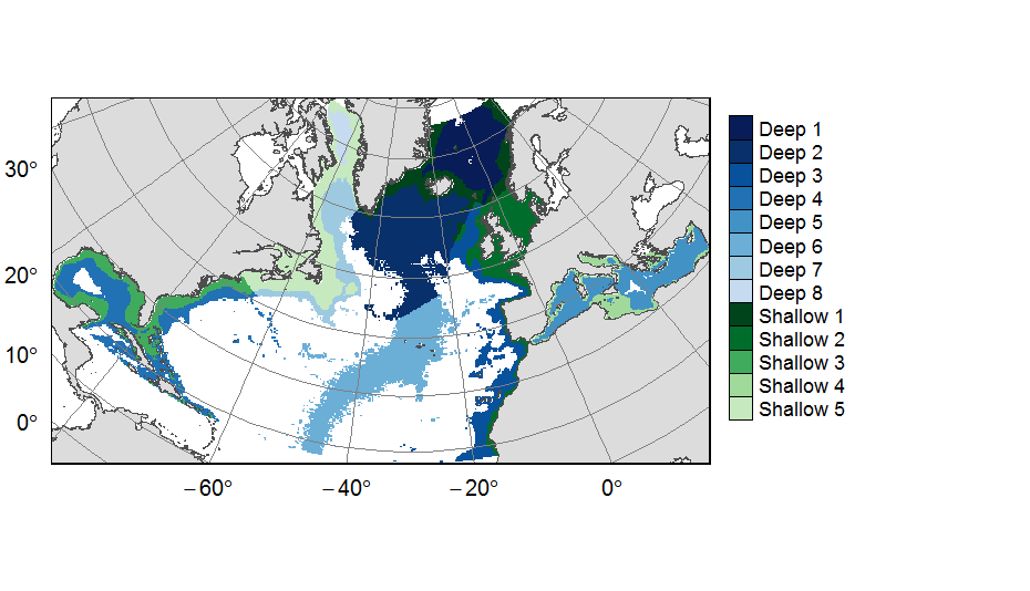
Planning units layers used for ATLAS EU prioritization scenarios on the North Atlantic (18°N to 76°N and 36°E to 98°W). This raster layer is designed on a grid of 25km * 25km resolution, that served to extract all the spatial data used prioritization. The 31 518 planning units (cells with value) corresponded to areas containing depths shallower or equal to 3500m, even if they could also contain deeper areas locally. For connectivity scenarios, only the planning units matching with the extent of available connectivity data were selected. One layer allocates planning units to the 13 geographical provinces (values ranging from 1 to 13) created for the purpose of prioritization.
This dataset was built to feed a basin-wide spatial conservation planning exercise, targeting the deep sea of the North Atlantic. The goal of this approach was to identify conservation priority areas for Vulnerable Marine Ecosystems (VMEs) and deep fish species, based on the distribution of species and habitats, human activities and current spatial management.
Simple
- Title
-
Planning units layers used in ATLAS spatial prioritization on the North Atlantic
- Date (Publication)
- 2019-08-14
- Citation identifier
- FR-330-715-368-00032-IFR_MARBEC_ATLAS_PU_layer
- Citation identifier
- DOI:10.12770/113cd9cb-0a30-4297-b93d-5cf10124105b
- Abstract
-
Planning units layers used for ATLAS EU prioritization scenarios on the North Atlantic (18°N to 76°N and 36°E to 98°W). This raster layer is designed on a grid of 25km * 25km resolution, that served to extract all the spatial data used prioritization. The 31 518 planning units (cells with value) corresponded to areas containing depths shallower or equal to 3500m, even if they could also contain deeper areas locally. For connectivity scenarios, only the planning units matching with the extent of available connectivity data were selected. One layer allocates planning units to the 13 geographical provinces (values ranging from 1 to 13) created for the purpose of prioritization.
This dataset was built to feed a basin-wide spatial conservation planning exercise, targeting the deep sea of the North Atlantic. The goal of this approach was to identify conservation priority areas for Vulnerable Marine Ecosystems (VMEs) and deep fish species, based on the distribution of species and habitats, human activities and current spatial management.
- Credit
-
Horizon 2020 ATLAS project (EU)
- Point of contact
-
Organisation name Individual name Electronic mail address Role IFREMER
Combes Magali
Author IFREMER
Vaz Sandrine
Author IFREMER
Publisher
-
Thèmes Sextant
-
-
/Biological Environment/Habitats
-
-
GEMET - INSPIRE themes, version 1.0
-
-
Habitats and biotopes
-
- Use limitation
- CC-BY-NC-SA (Creative Commons - Attribution, Pas d’utilisation commerciale, Partage dans les mêmes conditions)
- Access constraints
- License
- Use constraints
- License
- Spatial representation type
- Grid
- Distance
- 25 km
- Language
- English
- Character set
- UTF8
- Topic category
-
- Oceans
))
- Reference system identifier
- +proj=aea +lat_1=43 +lat_2=62 +lat_0=30 +lon_0=-30 +x_0=0 +y_0=0 +datum=WGS84 +units=m +no_defs +ellps=WGS84 +towgs84=0,0,0
- Number of dimensions
- 2
- Dimension name
- Row
- Dimension size
- 273
- Resolution
- 25 km
- Dimension name
- Column
- Dimension size
- 491
- Resolution
- 25 km
- Cell geometry
- Area
- Transformation parameter availability
- OnLine resource
-
Protocol Linkage Name OGC:WMS
https://sextant.ifremer.fr/services/wms/atlas_eu IFR_MARBEC_ATLAS_PROVINCES
COPYFILE
IFR_MARBEC_ATLAS_PROVINCES
- OnLine resource
-
Protocol Linkage Name OGC:WMS
https://sextant.ifremer.fr/services/wms/atlas_eu IFR_MARBEC_ATLAS_PULAYER
COPYFILE
IFR_MARBEC_ATLAS_PULAYER
- OnLine resource
-
Protocol Linkage Name OGC:WMS
https://sextant.ifremer.fr/services/wms/atlas_eu IFR_MARBEC_ATLAS_PULAYER_CONNECTIVITY
COPYFILE
IFR_MARBEC_ATLAS_PULAYER_CONNECTIVITY
- OnLine resource
-
Protocol Linkage Name DOI
https://doi.org/10.12770/113cd9cb-0a30-4297-b93d-5cf10124105b DOI of the dataset
- Hierarchy level
- Dataset
Conformance result
- Title
-
RÈGLEMENT (UE) N o 1089/2010 DE LA COMMISSION du 23 novembre 2010 portant modalités d'application de la directive 2007/2/CE du Parlement européen et du Conseil en ce qui concerne l'interopérabilité des séries et des services de données géographiques
- Date (Publication)
- 2010-12-08
- Explanation
-
See the referenced specification
- Statement
-
A 25km * 25 km resolution raster grid was computed using a depth layer of 3km * 3km resolution created by IMAR (Instituto do Mar, Universidade dos Açores, Horta, Portugal) for the ATLAS Deliverable 3.3. Deep (>3500m) areas were excluded and the remaining gridsquares (i.e. the planning units) were either considered as one entity or attributed to 13 regions created for the ATLAS spatial prioritization.
Source data reference: Telmo Morato, José-Manuel González-Irusta, Carlos Dominguez-Carrió, Chih-Lin Wei, Andrew
Davies, Andrew K. Sweetman, Gerald H. Taranto, Lindsay Beazley, Ana García-Alegre, Anthony
Grehan, Pascal Laffargue, F. Javier Murillo, Mar Sacau, Sandrine Vaz, Ellen Kenchington, Sophie
Arnaud-Haond, Oisin Callery, Giovanni Chimienti, Erik Cordes, Hronn Egilsdottir, André
Freiwald, Ryan Gasbarro, Matt Gianni; Kent Gilkinson, Vonda E. Wareham Hayes, Dierk
Hebbeln, Kevin Hedges, Lea-Anne Henry, Georgios Kazanidis, Mariano Koen-Alonso, Cam
Lirette, Francesco Mastrototaro, Lénaick Menot, Tina Molodtsova, Pablo Durán Muñoz,
Bramley Murton, Covadonga Orejas, Maria Grazia Pennino, Patricia Puerta, Stefán Á.
Ragnarsson, Berta Ramiro-Sánchez, Jake Rice, Jesús Rivera, Murray Roberts, Luís Rodrigues,
Steve W. Ross, José L. Rueda, Tim Siferd, Paul Snelgrove, David Stirling, Margaret Treble,
Javier Urra, Johanne Vad, Les Watling, Wojciech Walkusz, Zeliang Wang, Claudia Wienberg,
Mathieu Woillez, Lisa A. Levin, Francis Neat, Diya Das, Laurence Fauconnet, Claudia Viegas,
Pedro Afonso, Gui Menezes, Mario Rui Pinho, Helder Silva, Alexandra Rosa, Diana
Catarino, Eva Giacomello, Javi Guijarro, Jason Cleland, Isobel Yeo, Joana R. Xavier, Íris
Sampaio, Jeremy Spearman, Lissette Victorero, Charles G. Messing, Meri Bilan, Jordi
Blasco-Ferre, Jean-François Bourillet, Laurent de Chambure, Jaime S. Davies, Norbert Frank,
Brigitte Guillaumont, Konstantinos Georgoulas, Barbara Berx, Karine Olu, Manuela Ramos,
Laís Ramalho, Olga Reñones, José Antonio Caballero, Fernando Tempera, Julie Tourolle, Olga
Utrilla, Inge van den Beld, Olga Utrilla, Igor Yashayaev, Marina Carreiro-Silva (2019) ATLAS EU D3.3 Biodiversity, biogeography and GOODS classification system under current climate conditions and future IPCC scenarios. https://www.eu-atlas.org/resources/atlas-library
- Description
-
The depth layer was extracted from a bathymetry grid built from two data sources: the EMODnet Digital Bathymetry portal (EMODnet, 2016) and the General Bathymetric Chart of the Oceans (GEBCO, 2014). The original resolution from EMODnet (0.002°) was up-scaled to the GEBCO resolution (0.008°) using a bilinear interpolation. The bathymetry layers were merged by using EMODnet data when available and completing it with GEBCO 2014, and rescaled to the final resolution of 3x3 km using bilinear interpolation. References: EMODnet Bathymetry Consortium. (2016). EMODnet Digital Bathymetry (DTM 2016) [Data set]. https://doi.org/10.12770/c7b53704-999d-4721-b1a3-04ec60c87238 ; GEBCO (2014) .General Bathymetric Chart of the Oceans - GEBCO_2014 Grid. https://www.gebco.net/data_and_products/historical_data_sets/#gebco_2014
- Rationale
-
ATLAS depth layer computed by IMAR for D3.3
- Description
-
Using the R environment, cells with depths values deeper than 3500m were set to NA. The raster layer was disaggregated to a 1km * 1km resolution, and then aggregated again to a 25km * 25km resolution using the aggregate function from the raster package. A 1:10m land polygon layer from Natural Earth Data (www.naturalearthdata.com) was used to mask the cells having their centre situated on continents and cells with more than 20% of continent cover, which were determined using the rasterize function, were set to NA. This process led to a final number of 31 518 cells with values, each one representing a spatial planning unit in prioritization scenarios. For connectivity scenarios, the planning layer was reduced to 22 347 units to match with the extent of available connectivity data.
- Rationale
-
Planning units
- Description
-
Division of the study area in provinces was implemented sequentially using three criteria, that are supposed to influence the species’ population structure or biogeography and/or that capture large scale habitat heterogeneity. First, lower bathyal Global Open Oceans and Deep Seabed (GOODS) provinces (Vierros et al., 2009), delimited by the 800 and 3500 isobaths, were extended to the coastline to identify three large biogeographic regions. These large regions, partitioning the ocean basin in latitudinal sections, were then divided in two to four longitudinal sections following geographical cuts: the West Atlantic abyssal plain and Greenland; the East Atlantic abyssal plain; and the Atlantic-Mediterranean separation. Finally, each of the eight resulting regions was independently split in two, according to the mean depth in 25km*25km cells. Following the original GOODS regions, two depth ranges were created, shallow (<800m) and deep (>800m), leading to 16 sub-regions. Because of the small area of certain sub-regions, and of geographical contiguity, three pairs of sub-regions were merged together to form 3 more coherent regions (“deep 7”, “shallow 1”, and “shallow 5”). This process led to 13 provinces, including eight “deep” provinces, and five “shallow” provinces. Reference: Vierros, M., Cresswell, I., Briones, E. E., Rice, J., & Ardron, J. (2009). Global Open Oceans and Deep Seabed (GOODS) biogeographic classification. UNESCO.
- Rationale
-
Provinces
Metadata
- File identifier
- 113cd9cb-0a30-4297-b93d-5cf10124105b
- Metadata language
- English
- Character set
- UTF8
- Hierarchy level
- Dataset
- Date stamp
- 2025-01-28T08:40:22.712001Z
- Metadata standard name
-
ISO 19115:2003/19139 - SEXTANT
- Metadata standard version
-
1.0
- Metadata author
-
Organisation name Individual name Electronic mail address Role IFREMER
Vaz Sandrine
Author IFREMER
Combes Magali
Author
)))