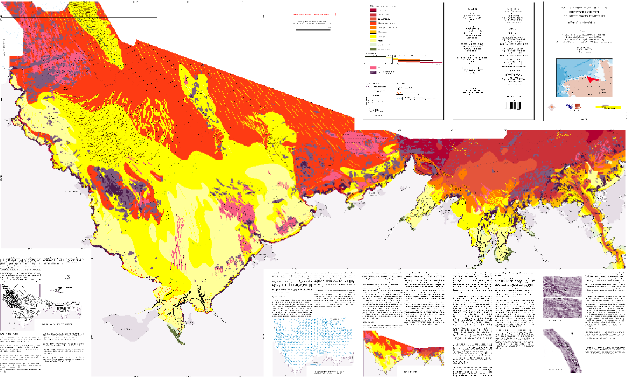
Formations superficielles du domaine marin côtier de l'anse de Paimpol à Saint-Malo (Côtes-d'Armor - Ille-et-Vilaine), scan géoréférencé
Scan géoréférencé de la carte des formations superficielles du domaine marin côtier de l'anse de Paimpol à Saint-Malo (édition 2006 ; échelle 1/50000).
Campagnes océanographiques à l'origine de cette carte :
- ARZEL Pierre (1986) COQUILLES cruise, RV Thalia, https://doi.org/10.17600/86010511
- AUGRIS Claude (1987) AMBRE 87 (AMBRE2) cruise, RV Thalia, https://doi.org/10.17600/87009011
- AUGRIS Claude (1991) CABRI 1 cruise, RV Thalia, https://doi.org/10.17600/91070030
- AUGRIS Claude, HAMON Dominique (1992) CABRI 2 cruise, RV Thalia, https://doi.org/10.17600/92070080
- AUGRIS Claude (1992) CABRI 3 cruise, RV Thalia, https://doi.org/10.17600/92070090
- HAMON Dominique (1993) CABRI 4 cruise, RV Thalia, https://doi.org/10.17600/93000750
- HAMON Dominique (1994) PROLCRE cruise, RV Thalia, https://doi.org/10.17600/94070160
- HAMON Dominique (1995) CREPIBIO 1 cruise, RV Thalia, https://doi.org/10.17600/95070050
- BLANCHARD Michel (1995) CREPE 1 cruise, RV Thalia, https://doi.org/10.17600/95070140
- CREPE 2 (1995), non référencée
- BLANCHARD Michel (1996) CREPE 3 cruise, RV Thalia, https://doi.org/10.17600/96070050
Références bibliographiques :
- Augris Claude, Hamon Dominique (1996). Atlas thématique de l'environnement marin en baie de Saint-Brieuc (Côtes-d'Armor). Ifremer. https://archimer.ifremer.fr/doc/00031/14246/
- Augris Claude, Blanchard Michel, Bonnot-Courtois Chantal. Carte des formations superficielles entre le cap Fréhel et Saint-Malo (Côtes d'Armor - Ille-et-Vilaine)
- Augris Claude, Clabaut Philippe (2001). Cartographie géologique des fonds marins côtiers. Exemples le long du littoral français. Ifremer.
Simple
- Title
-
Formations superficielles du domaine marin côtier de l'anse de Paimpol à Saint-Malo (Côtes-d'Armor - Ille-et-Vilaine), scan géoréférencé
- Date (Publication)
- 2006-01-01T00:00:00
- Date (Creation)
- 2006-08-01T00:00:00
- Edition
-
carte papier, édition Ifremer
- Edition date
- 2006-01-01T00:00:00
- Citation identifier
- FR-330-715-368-00032-FormationsSup_PaimpolStMalo_Augris_2006_ScanGeoref
- Presentation form
- Digital map
- ISBN
-
2-84433-156-4
- Abstract
-
Scan géoréférencé de la carte des formations superficielles du domaine marin côtier de l'anse de Paimpol à Saint-Malo (édition 2006 ; échelle 1/50000).
Campagnes océanographiques à l'origine de cette carte :
- ARZEL Pierre (1986) COQUILLES cruise, RV Thalia, https://doi.org/10.17600/86010511
- AUGRIS Claude (1987) AMBRE 87 (AMBRE2) cruise, RV Thalia, https://doi.org/10.17600/87009011
- AUGRIS Claude (1991) CABRI 1 cruise, RV Thalia, https://doi.org/10.17600/91070030
- AUGRIS Claude, HAMON Dominique (1992) CABRI 2 cruise, RV Thalia, https://doi.org/10.17600/92070080
- AUGRIS Claude (1992) CABRI 3 cruise, RV Thalia, https://doi.org/10.17600/92070090
- HAMON Dominique (1993) CABRI 4 cruise, RV Thalia, https://doi.org/10.17600/93000750
- HAMON Dominique (1994) PROLCRE cruise, RV Thalia, https://doi.org/10.17600/94070160
- HAMON Dominique (1995) CREPIBIO 1 cruise, RV Thalia, https://doi.org/10.17600/95070050
- BLANCHARD Michel (1995) CREPE 1 cruise, RV Thalia, https://doi.org/10.17600/95070140
- CREPE 2 (1995), non référencée
- BLANCHARD Michel (1996) CREPE 3 cruise, RV Thalia, https://doi.org/10.17600/96070050
Références bibliographiques :
- Augris Claude, Hamon Dominique (1996). Atlas thématique de l'environnement marin en baie de Saint-Brieuc (Côtes-d'Armor). Ifremer. https://archimer.ifremer.fr/doc/00031/14246/
- Augris Claude, Blanchard Michel, Bonnot-Courtois Chantal. Carte des formations superficielles entre le cap Fréhel et Saint-Malo (Côtes d'Armor - Ille-et-Vilaine)
- Augris Claude, Clabaut Philippe (2001). Cartographie géologique des fonds marins côtiers. Exemples le long du littoral français. Ifremer.
- Credit
-
Ifremer / CNRS / EPHE
- Status
- Completed
- Point of contact
-
Organisation name Individual name Electronic mail address Role Ifremer
Geo-Ocean
Local service desk Ifremer
AUGRIS Claude
Author CNRS
BONNOT-COURTOIS Chantal
Author EPHE
LE VOT Monique
Author Consultant
HOULGATTE Eric
Author Ifremer
MAZE Jean-Pierre
Author Ifremer
CRUSSON Alban
Author Ifremer
SIMPLET Laure
Author Ifremer
BLANCHARD Michel
Author
- Maintenance and update frequency
- Not planned
-
Thèmes Sextant
-
-
/Cartes scannées/Ifremer/Sédimentologie
-
-
GEMET - INSPIRE themes, version 1.0
-
-
Géologie
-
-
external.theme.gemet
-
-
Sédiment marin
-
Fond marin
-
- Theme
-
-
Formations superficielles
-
Nature des fonds
-
- Place
-
-
Paimpol
-
Saint-Brieuc
-
Saint-Malo
-
Côtes d'Armor
-
Ille-et-Vilaine
-
Bretagne
-
Manche
-
Baie de Saint-Brieuc
-
- Discipline
-
-
Géophysique
-
Sédimentologie
-
- Use limitation
-
CC BY. Licence Creative Commons Attribution 4.0 International https://creativecommons.org/licenses/by/4.0/
- Access constraints
- Other restrictions
- Use constraints
- License
- Other legal constraints
-
Pas de restriction d'accès public
- Other legal constraints
-
Proposition de citation : AUGRIS C., BONNOT-COURTOIS C., MAZE J. P., LE VOT P., CRUSSON A., SIMPLET L., HOULGATTE E., BLANCHARD M. (2006) - Carte des formations superficielles du domaine marin côtier de l'anse de Paimpol à Saint-Malo (Côtes d'Armor - Ille-et-Vilaine). Echelle 1/50 000. Ed. Ifremer
- Spatial representation type
- Grid
- Denominator
- 50000
- Language
- Français
- Character set
- UTF8
- Topic category
-
- Geoscientific information
- Description
-
Période d'acquisition des données
- Begin date
- 1986-04-02T15:38:00
- End date
- 1996-04-21T15:39:00
))
- Supplemental Information
-
Deux autres jeux de données sont à associer pour cette étude :
-> Jeu de données vectoriel des formations superficielles, sous forme de polygones. Il contient les faciès sédimentaires, et les figures sédimentaires surfaciques.
-> Jeu de données vectoriel des formations superficielles, sous forme de polylignes. Il contient les figures sédimentaires linéaires.
- Reference system identifier
- EPSG / ED50 (EPSG:4230) / 7.4
- Number of dimensions
- 2
- Dimension name
- Column
- Dimension size
- 8691
- Resolution
- 8.461058 mètre,
- Dimension name
- Row
- Dimension size
- 5263
- Resolution
- 8.464349 mètre,
- Cell geometry
- Area
- Transformation parameter availability
Distributor
- Distributor contact
-
Organisation name Individual name Electronic mail address Role Ifremer - Centre de Brest
Dissemination Unit
- Distributor format
-
Name Version GeoTIFF
1.0
- OnLine resource
-
Protocol Linkage Name OGC:WMS
https://sextant.ifremer.fr/services/wms/gm_geologie FormationsSup_PaimpolStMalo_Augris_2006_ScanGeoref
COPYFILE
FormationsSup_PaimpolStMalo_Augris_2006_ScanGeoref
- OnLine resource
-
Protocol Linkage Name WWW:LINK
http://dx.doi.org/10.17600/86010511 WWW:LINK
http://dx.doi.org/10.17600/91070030 WWW:LINK
http://dx.doi.org/10.17600/92070080 WWW:LINK
http://dx.doi.org/10.17600/92070090 WWW:LINK
http://dx.doi.org/10.17600/93000750 WWW:LINK
http://dx.doi.org/10.17600/94070160 WWW:LINK
http://dx.doi.org/10.17600/95070050 WWW:LINK
http://dx.doi.org/10.17600/95070140 WWW:LINK
http://dx.doi.org/10.17600/96070050 WWW:LINK
https://doi.org/10.17600/87009011 Campagne AMBRE 87 (AMBRE2)
WWW:LINK
http://archimer.ifremer.fr/doc/00031/14246/ Atlas Baie de St-Brieuc (1996)
- Hierarchy level
- Dataset
Conformance result
- Title
-
INSPIRE
- Date (Publication)
- 2007-03-14
- Explanation
-
Non évalué
- Pass
- Statement
-
Carte originale papier scannée et géoréférencée.
Metadata
- File identifier
- 129c5fa0-bb50-11df-a9b6-005056987263
- Metadata language
- Français
- Character set
- UTF8
- Hierarchy level
- Dataset
- Date stamp
- 2024-03-25T13:25:12.587Z
- Metadata standard name
-
ISO 19115:2003/19139 - SEXTANT
- Metadata standard version
-
1.0
- Metadata author
-
Organisation name Individual name Electronic mail address Role Ifremer
Geo-Ocean
Local service desk
accessData
Overviews
)))