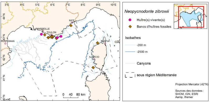
Neopycnodonte zibrowii distribution observed by submersible between 1995 and 2011 in the French Mediterranean
Species distribution is provided as a layer of points representing in situ observations of organisms during submersible dives into the canyons of the Mediterranean mainland.
Simple
- Title
-
Neopycnodonte zibrowii distribution observed by submersible between 1995 and 2011 in the French Mediterranean
- Date (Creation)
- 2011-06-01
- Citation identifier
- Neopycnodonte_zibrowii_MED_2011
- Abstract
-
Species distribution is provided as a layer of points representing in situ observations of organisms during submersible dives into the canyons of the Mediterranean mainland.
- Credit
-
Ifremer Toulon LER/PAC
- Point of contact
-
Organisation name Individual name Electronic mail address Role Ifremer Toulon LER/PAC
Author
-
Thèmes Sextant
-
-
/Biological Environment/Species/Rare, Protected Species, and Species in Danger of Extinction
-
- Theme
-
-
Fauna
-
Neopycnodonte zibrowii
-
Bathyal and abyssal biota
-
hard bottom
-
-
GEMET - INSPIRE themes, version 1.0
-
-
Species distribution
-
- Place
-
-
Mediterranean
-
bathyal
-
-
Sous-regions marines
-
-
/Metropolitan France/Western Mediterranean
-
-
Thématiques - SIMM
-
-
/Environmental Status/Species
-
Research
-
-
Type de jeux de donnée ODATIS
-
-
/Processed data/Composite products
-
- Use limitation
-
On-demand access. Broadcast and modification are forbidden without the express consent of the author.
- Access constraints
- Restricted
- Use constraints
- Restricted
- Other legal constraints
-
Distribution and modification prohibited without the consent of the author.
- Classification
- Restricted
- Spatial representation type
- Vector
- Distance
- 20 metre
- Language
- Français
- Character set
- UTF8
- Topic category
-
- Biota
))
- Begin date
- 1995-01-01T17:41:00
- End date
- 2011-12-31T17:41:00
- Reference system identifier
- EPSG / WGS84 géographiques / 7.4
- Geometric object type
- Point
- Geometric object count
- 29
- Distribution format
-
Name Version shape ESRI
ArcGIS 9.3.1
- OnLine resource
-
Protocol Linkage Name WWW:LINK
http://wwz.ifremer.fr/dcsmm site internet Ifremer dédié à la Directive Cadre Stratégie pour le Milieu Marin
WWW:LINK
http://www.ifremer.fr/sextant/fr/web/dcsmm/226b_biocenoses_fonds_durs_bathyal_abyssal carthothèque DCSMM
- Hierarchy level
- Dataset
- Statement
-
Acquisition data by submersible videos during the campaigns: CYATOX 1995, CYLICE 1997, ESSNAUT 2008, MARUM 2009, MEDSEACAN 2009, ESSROV 2010, ESSROV 2011.
Ifremer: Cyana, Nautile, Victor / Comex: Achille, Remora
Video processing by Ifremer software Adelie (in GIS)
Fauna recognition by images and quantitative data estimated from videos occurrences.
Metadata
- File identifier
- 1308daf5-6ef8-4aff-8c53-d30928d9f676
- Metadata language
- Français
- Other language
-
Language Character encoding English
- Character set
- UTF8
- Hierarchy level
- Dataset
- Hierarchy level name
-
Jeu de données
- Date stamp
- 2020-06-04T01:02:08
- Metadata standard name
-
ISO 19115:2003/19139 - SEXTANT
- Metadata standard version
-
1.0
- Metadata author
-
Organisation name Individual name Electronic mail address Role Ifremer Toulon LER/PAC
Local service desk
accessData
Overviews
)))