Bathymetry - Kerguelen Islands (synthesis, 2025) cell size 200 m
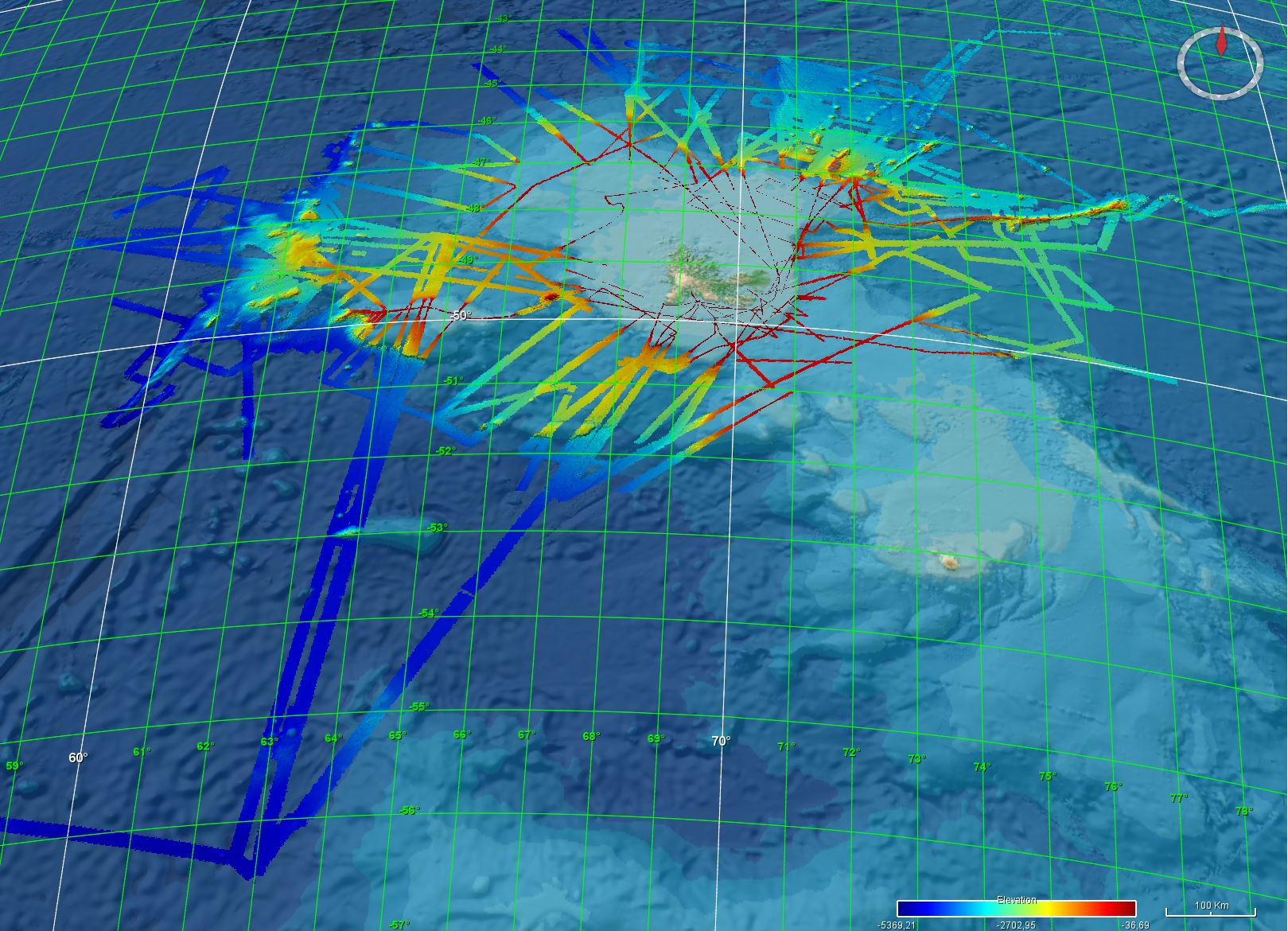
Bathymetry around the Kerguelen Islands: the Digital Terrain Model results from the data compilation of multibeam surveys from 1998 to 2011. Grid resolution is 200 m.
The DTM has been processed as part of the French national program (EXTRAPLAC) for the delineation of the outer limit of the continental shelf beyond 200 nautical miles
- MD137-Kergueplac1 cruise, ROEST Walter (2004), RV Marion Dufresne, https://doi.org/10.17600/4200040
- MD 150 /DELCANO RISE-KERGUEPLAC2 cruise, ROEST Walter (2005), RV Marion Dufresne, https://doi.org/10.17600/5200060
- MD 165 / KERGUEPLAC 3 cruise, VIALLY Roland, BRUNET Christian, ROYER Jean-Yves (2008), RV Marion Dufresne, https://doi.org/10.17600/8200010
- KERIMIS-MD109 cruise, SCHLICH Roland (1998), RV Marion Dufresne, https://doi.org/10.17600/98200010
- VT 51 / OISO 6 cruise, METZL Nicolas, PIERRE Catherine (2001), RV Marion Dufresne, https://doi.org/10.17600/1200010
- MD 125 / SWIFT BIS-CARHOT cruise, ASLANIAN Daniel, HUMLER Eric, MICHEL Elisabeth (2002), RV Marion Dufresne, https://doi.org/10.17600/2200020
- MD 136 / VIGO cruise, MICHEL Elisabeth (2004), RV Marion Dufresne, https://doi.org/10.17600/4200110
- MD 185 / INDIEN SUD 1 cruise, MAZAUD Alain, MICHEL Elisabeth (2011), RV Marion Dufresne, https://doi.org/10.17600/11200030
- MD 189 / INDIEN SUD 2 cruise, MAZAUD Alain, MICHEL Elisabeth (2012), RV Marion Dufresne, https://doi.org/10.17600/12200010
- MD174 / VIVIER Frédéric (2009) MD 174 / TRACK-2 cruise, RV Marion Dufresne, https://doi.org/10.17600/9200080
- MD 240 - OHA-SIS-BIO / ROYER Jean-Yves (2023) OHA-SIS-BIO 2023 cruise, RV Marion Dufresne, https://doi.org/10.17600/18002425
- GEODAMS / ROYER Jean-Yves, OLIVE Jean-Arthur (2024) OHA-GEODAMS 2024 cruise, RV Marion Dufresne, https://doi.org/10.17600/18003036
Simple
- Title
-
Bathymetry - Kerguelen Islands (synthesis, 2025) cell size 200 m
- Date (Creation)
- 2019-04-26
- Date (Revision)
- 2025-01-31
- Date (Publication)
- 2019-04-26
- Citation identifier
- FR-330715-368-00032-Synthese_Kerguelen_200m_BATHY
- Citation identifier
- DOI:10.12770/1909f2fb-09ee-49e3-8b5f-52b12e53d292
- Cited responsible party
-
Organisation name Individual name Electronic mail address Role Ifremer
Géosciences Marines
Local service desk
- Presentation form
- Digital model
- Abstract
-
Bathymetry around the Kerguelen Islands: the Digital Terrain Model results from the data compilation of multibeam surveys from 1998 to 2011. Grid resolution is 200 m.
The DTM has been processed as part of the French national program (EXTRAPLAC) for the delineation of the outer limit of the continental shelf beyond 200 nautical miles
- MD137-Kergueplac1 cruise, ROEST Walter (2004), RV Marion Dufresne, https://doi.org/10.17600/4200040
- MD 150 /DELCANO RISE-KERGUEPLAC2 cruise, ROEST Walter (2005), RV Marion Dufresne, https://doi.org/10.17600/5200060
- MD 165 / KERGUEPLAC 3 cruise, VIALLY Roland, BRUNET Christian, ROYER Jean-Yves (2008), RV Marion Dufresne, https://doi.org/10.17600/8200010
- KERIMIS-MD109 cruise, SCHLICH Roland (1998), RV Marion Dufresne, https://doi.org/10.17600/98200010
- VT 51 / OISO 6 cruise, METZL Nicolas, PIERRE Catherine (2001), RV Marion Dufresne, https://doi.org/10.17600/1200010
- MD 125 / SWIFT BIS-CARHOT cruise, ASLANIAN Daniel, HUMLER Eric, MICHEL Elisabeth (2002), RV Marion Dufresne, https://doi.org/10.17600/2200020
- MD 136 / VIGO cruise, MICHEL Elisabeth (2004), RV Marion Dufresne, https://doi.org/10.17600/4200110
- MD 185 / INDIEN SUD 1 cruise, MAZAUD Alain, MICHEL Elisabeth (2011), RV Marion Dufresne, https://doi.org/10.17600/11200030
- MD 189 / INDIEN SUD 2 cruise, MAZAUD Alain, MICHEL Elisabeth (2012), RV Marion Dufresne, https://doi.org/10.17600/12200010
- MD174 / VIVIER Frédéric (2009) MD 174 / TRACK-2 cruise, RV Marion Dufresne, https://doi.org/10.17600/9200080
- MD 240 - OHA-SIS-BIO / ROYER Jean-Yves (2023) OHA-SIS-BIO 2023 cruise, RV Marion Dufresne, https://doi.org/10.17600/18002425
- GEODAMS / ROYER Jean-Yves, OLIVE Jean-Arthur (2024) OHA-GEODAMS 2024 cruise, RV Marion Dufresne, https://doi.org/10.17600/18003036
- Credit
-
Ifremer
- Point of contact
-
Organisation name Individual name Electronic mail address Role Ifremer
Ifremer Marine Geosciences
Author Ifremer
LOUBRIEU Benoît
Author Ifremer
Ifremer
Publisher
- Maintenance and update frequency
- As needed
- Discipline
-
-
Bathymetry
-
- Place
-
-
Kerguelen islands
-
-
GEMET - Concepts, version 3.1
-
-
Seabed geo-morphology
-
Seabed mapping
-
- Use limitation
-
Not to be used for navigation.
- Access constraints
- Other restrictions
- Use constraints
- License
- Other legal constraints
-
Open access
- Spatial representation type
- Grid
- Distance
- 200 m
- Denominator
- 400000
- Language
- Français
- Character set
- UTF8
- Topic category
-
- Elevation
- Environment description
-
Version 6.2 (Build 9200) ; Esri ArcGIS 10.7.1.11595
))
- Reference system identifier
- EPSG / WGS84 / WORLD MERCATOR (EPSG3395) latitude 45°S / 8.2.6
- Number of dimensions
- 2
- Dimension name
- Column
- Dimension size
- 7294
- Resolution
- 200 m
- Dimension name
- Row
- Dimension size
- 5441
- Resolution
- 200 m
- Cell geometry
- Area
- Transformation parameter availability
- Checkpoint Availability
Center point
- Point in Pixel
-
- Center
- OnLine resource
-
Protocol Linkage Name DOI
https://doi.org/10.12770/1909f2fb-09ee-49e3-8b5f-52b12e53d292 DOI du jeu de donnée
NETWORK:LINK
INDIEN\Kerguelen\SIG\05_BATHY\00_SYNTHESES Synthese_Kerguelen_200m_BATHY
- OnLine resource
-
Protocol Linkage Name OGC:WMS
https://sextant.ifremer.fr/services/wms/gm_bathy Synthese_Kerguelen_200m_BATHY
- OnLine resource
-
Protocol Linkage Name COPYFILE
Synthese_Kerguelen_200m_BATHY
- Hierarchy level
- Dataset
- Statement
-
Multibeam data were controlled and processed with Ifremer software (Caraïbes and Globe).
A similar processing chain is applied to each dataset:
- Selection of relevant profiles for acoustic coverage of the study area
- Automatic and manual filtering of outliers and erroneous data
- Control of overlapping zones
- Production of a digital terrain model. Depth layer is calculated as the average of soundings in each pixel.
All DTMs are merged into a unique DTM for the area. Grid resolution is 200 m.
Metadata
- File identifier
- 1909f2fb-09ee-49e3-8b5f-52b12e53d292
- Metadata language
- Français
- Other language
-
Language Character encoding English
- Character set
- UTF8
- Hierarchy level
- Dataset
- Hierarchy level name
-
dataset
- Date stamp
- 2025-03-03T08:03:13.191294Z
- Metadata standard name
-
ISO 19115:2003/19139 - SEXTANT
- Metadata standard version
-
V. 1.2
- Metadata author
-
Organisation name Individual name Electronic mail address Role Ifremer
Géosciences Marines
Local service desk
)))