Bathymetry and seafloor variables at 5-m resolution in the Lacaze-Duthiers Canyon, below130 m depth
Seafloor variables were derived from the digital terrain models (DTMs) at a 5-m resolution for the entire canyon. The Lacaze-Duthiers Canyon was first delineated, and only data below 130 m depth were retained.
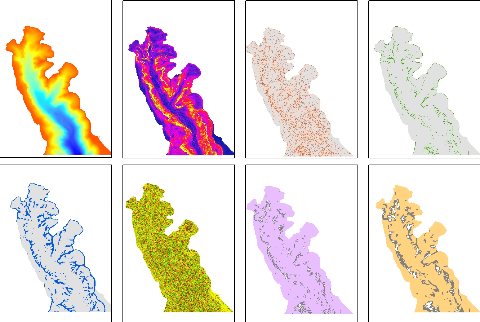
The dataset is composed of 15 variables : Bathymetry; Slope; Aspect; Curvature; Surface area to Planar area; Vector Ruggedness Measure (VRM) computed using 9, 25 and 49 pixels; and Bathymetric Position Index (BPI) calculated using windows of 3, 9, 11, 25, 49, 81, and 250 pixels.
This dataset was produced to assess the probable distribution of habitats (habitat suitability modeling) for cold-water corals in the Lacaze-Duthiers Canyon at different resolutions as part of the European H2020 project REDRESS (Restoration of Deep-Sea Habitats to Rebuild European Seas, https://redress-project.eu/, Grant Agreement No. 101135492).
This dataset is related to the article "Mapping and Conservation of Cold-Water Corals in the Lacaze-Duthiers Canyon for Transboundary Management", submitted to Mediterranean Marine Science by Fabri et al. in 2025.
Simple
- Title
-
Bathymetry and seafloor variables at 5-m resolution in the Lacaze-Duthiers Canyon, below130 m depth
- Date (Creation)
- 2024-03-18
- Date (Publication)
- 2025-03-25
- Citation identifier
- LD_Seafloor_variables_5m_under130m
- Abstract
-
Seafloor variables were derived from the digital terrain models (DTMs) at a 5-m resolution for the entire canyon. The Lacaze-Duthiers Canyon was first delineated, and only data below 130 m depth were retained.
The dataset is composed of 15 variables : Bathymetry; Slope; Aspect; Curvature; Surface area to Planar area; Vector Ruggedness Measure (VRM) computed using 9, 25 and 49 pixels; and Bathymetric Position Index (BPI) calculated using windows of 3, 9, 11, 25, 49, 81, and 250 pixels.
This dataset was produced to assess the probable distribution of habitats (habitat suitability modeling) for cold-water corals in the Lacaze-Duthiers Canyon at different resolutions as part of the European H2020 project REDRESS (Restoration of Deep-Sea Habitats to Rebuild European Seas, https://redress-project.eu/, Grant Agreement No. 101135492).
This dataset is related to the article "Mapping and Conservation of Cold-Water Corals in the Lacaze-Duthiers Canyon for Transboundary Management", submitted to Mediterranean Marine Science by Fabri et al. in 2025.
- Credit
-
Ifremer
- Point of contact
-
Organisation name Individual name Electronic mail address Role IFREMER
Fabri Marie-Claire
Author IFREMER
Dreidemy Jeanne
Author IFREMER
Publisher
-
Thèmes Sextant
-
-
/Milieu physique/Bathymétrie
-
-
GEMET - INSPIRE themes, version 1.0
-
-
Caractéristiques géographiques océanographiques
-
- Use limitation
- CC-BY (Creative Commons - Attribution)
- Access constraints
- Copyright
- Use constraints
- Copyright
- Other legal constraints
-
Cite the CALADU_2021 cruise (https://doi.org/10.17600/18001575)
- Association Type
- Source
- Initiative Type
- Campaign
- Association Type
- Cross reference
- Association Type
- Cross reference
- Association Type
- Cross reference
- Association Type
- Cross reference
- Spatial representation type
- Grid
- Distance
- 10 meter
- Language
- English
- Character set
- UTF8
- Topic category
-
- Oceans
- Environment
))
- Begin date
- 2021-07-01
- End date
- 2021-07-31
- Unique resource identifier
- EPSG:3395 Parallèle standard 42°30'N
- Number of dimensions
- 0
- Cell geometry
- Area
- Transformation parameter availability
- Distribution format
-
Name Version
- OnLine resource
-
Protocol Linkage Name COPYFILE
Bathymetry_seafloor_variables_5m
- OnLine resource
-
Protocol Linkage Name DOI
https://doi.org/10.12770/1cc30b12-ad4e-415f-8f1f-ad690e0c266c Digital Object Identifier (DOI)
- Hierarchy level
- Dataset
Conformance result
- Title
-
RÈGLEMENT (UE) N o 1089/2010 DE LA COMMISSION du 23 novembre 2010 portant modalités d'application de la directive 2007/2/CE du Parlement européen et du Conseil en ce qui concerne l'interopérabilité des séries et des services de données géographiques
- Date (Publication)
- 2010-12-08
- Explanation
-
See the referenced specification
- Statement
-
Seafloor indices were derived from a DTM collected during CALADU_2021 cruise using Benthic Terrain Modeler extension in ArcMap 10.7 (ESRI).
Metadata
- File identifier
- 1cc30b12-ad4e-415f-8f1f-ad690e0c266c
- Metadata language
- Français
- Character set
- UTF8
- Hierarchy level
- Dataset
- Date stamp
- 2025-04-10T15:41:32.148739Z
- Metadata standard name
-
ISO 19115:2003/19139 - SEXTANT
- Metadata standard version
-
1.0
- Metadata author
-
Organisation name Individual name Electronic mail address Role IFREMER
Fabri Marie-Claire
Author
)))