Continuous Monitoring Programme «Intertidal Benthic Habitats » RNF
Test phase of the RNF protocol of continuous monitoring of intertidal biomorphosedimentary habitats in estuaries
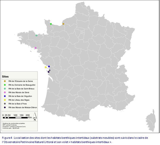
- RN involved in the test phase: Baie de Somme, Seine estuary Domaine de Beauguillot, Baie de Saint-Brieuc, Marais de Séné, Marais de Müllembourg, Baie de l'Aiguillon, Lilleau des Niges, Marais d'Yves et Marais de Moëze-Oléron –
Main objective : to establish a multi-site monitoring protocol for studying intertidal biomorphosedimentary habitats in estuaries, to be implemented on the scale of the RNF Observatory “Coasts, waders and benthic macrofauna” in order to provide long-term data and conduct comparative analyses on a national level.
These habitats are a source of food for coastal waders. Therefore their long-term evolution is, at least in part, a condition of the quality of estuary sites and their capacity as habitats for coastal waders.
Suited to soft substrate in intertidal areas, this protocol must specify the main characteristics of benthic communities in the estuaries: biomorphosedimentary, taxonomic, density and biometric* approaches (* : only for the principal bivalve molluscs), and must also measure changes over time. In order to be able to continue the programme each year, taking into account the implementation capacity of managing teams (time available, necessary equipment, methodological feasibility), the RNF protocol was designed to be easily standardised and applicable on an annual basis.
In connection with the monthly coastal wader counts, this biomorphosedimentary approach was designed so that the information gathered might also inform us of the quality of feeding grounds frequented by the birds at low tide :
- Choice to take samples in autumn, around 15 October in order to conduct an inventory of the resource prior to the arrival of large numbers of wading birds (before the predatory effects of the birds’ presence)
- Sampling for each geographical entity of the three biomorphosedimentary habitats (identification thanks to the three first levels of the EUNIS classification) present in terms of the functional unit defined for coastal wading birds
- 25-cm fauna Core samples in order to account for the overall space where the fauna-prey of the wading birds is distributed
- 5-cm fauna Core samples in order to understand the quality of surface sediments, which is one of the parameter influencing the accessibility and detectability of benthic resources by wading birds. Thus, in the long term, by confronting datasets from both the developed protocols (coastal waders and biomorphosedimentary habitats), correspondences between sites could be made between benthic communities and communities of wading birds in order to achieve a comparative functional approach to the areas monitored, on a national scale.
Finally, there are already numerous other monitoring programmes for many of the sites studied within the context of our RNF programme. Therefore, the protocol that we are developing, which draws on existing methods and is adapted to the same geographical scale (Rebent network and DCEo protocols), must in the long term enable us to reinforce existing networks by completing the spatial and temporal coverage of certain habitats. Even if the initial objectives of these various measures are markedly different, the aim of the protocol developed here is to complete those which already exist.
Simple
- Title
-
Continuous Monitoring Programme «Intertidal Benthic Habitats » RNF
- Date (Creation)
- 2007-01-01T00:00:00
- Citation identifier
- FR-DCSMM-PDS-OBSERVATOIRE_RNF
- Presentation form
- Digital profile
- Abstract
-
Test phase of the RNF protocol of continuous monitoring of intertidal biomorphosedimentary habitats in estuaries
- RN involved in the test phase: Baie de Somme, Seine estuary Domaine de Beauguillot, Baie de Saint-Brieuc, Marais de Séné, Marais de Müllembourg, Baie de l'Aiguillon, Lilleau des Niges, Marais d'Yves et Marais de Moëze-Oléron –
Main objective : to establish a multi-site monitoring protocol for studying intertidal biomorphosedimentary habitats in estuaries, to be implemented on the scale of the RNF Observatory “Coasts, waders and benthic macrofauna” in order to provide long-term data and conduct comparative analyses on a national level.
These habitats are a source of food for coastal waders. Therefore their long-term evolution is, at least in part, a condition of the quality of estuary sites and their capacity as habitats for coastal waders.
Suited to soft substrate in intertidal areas, this protocol must specify the main characteristics of benthic communities in the estuaries: biomorphosedimentary, taxonomic, density and biometric* approaches (* : only for the principal bivalve molluscs), and must also measure changes over time. In order to be able to continue the programme each year, taking into account the implementation capacity of managing teams (time available, necessary equipment, methodological feasibility), the RNF protocol was designed to be easily standardised and applicable on an annual basis.
In connection with the monthly coastal wader counts, this biomorphosedimentary approach was designed so that the information gathered might also inform us of the quality of feeding grounds frequented by the birds at low tide :
- Choice to take samples in autumn, around 15 October in order to conduct an inventory of the resource prior to the arrival of large numbers of wading birds (before the predatory effects of the birds’ presence)
- Sampling for each geographical entity of the three biomorphosedimentary habitats (identification thanks to the three first levels of the EUNIS classification) present in terms of the functional unit defined for coastal wading birds
- 25-cm fauna Core samples in order to account for the overall space where the fauna-prey of the wading birds is distributed
- 5-cm fauna Core samples in order to understand the quality of surface sediments, which is one of the parameter influencing the accessibility and detectability of benthic resources by wading birds. Thus, in the long term, by confronting datasets from both the developed protocols (coastal waders and biomorphosedimentary habitats), correspondences between sites could be made between benthic communities and communities of wading birds in order to achieve a comparative functional approach to the areas monitored, on a national scale.
Finally, there are already numerous other monitoring programmes for many of the sites studied within the context of our RNF programme. Therefore, the protocol that we are developing, which draws on existing methods and is adapted to the same geographical scale (Rebent network and DCEo protocols), must in the long term enable us to reinforce existing networks by completing the spatial and temporal coverage of certain habitats. Even if the initial objectives of these various measures are markedly different, the aim of the protocol developed here is to complete those which already exist.
- Credit
-
Producteurs de données : RNN Baie de Somme, Syndicat Mixte
Somme-Grand littoral picard, RNN Estuaire de la Seine, Maison de l’Estuaire, Cellule de Suivi du Littoral Normand, RNN Domaine de Beauguillot, Asso. Claude Hettier de Boislambert, GEMEL-
Normandie, RNN Baie de Saint-Brieuc, Saint-Brieuc Agglomération, Maison de la Baie de Saint-Brieuc, Vivarmor Nature, RNN Marais de Séné, SEPNB-Bretagne Vivante, RNN Baie de l’Aiguillon, LPO Vendée, ONCFS Bretagne-Pays de le Loire, RNN Marais d’Yves, LPO Charente-Maritime, RNN Lilleau des Niges, RNN Moëze- Oléron, LIENSs-Université de La Rochelle
- Status
- On going
- Point of contact
-
Organisation name Individual name Electronic mail address Role Réserves Naturels de France
CAILLOT Emmanuel
Local service desk
- Maintenance and update frequency
- Irregular
- Maintenance note
-
Network Duration: perennial Device
- Theme
-
-
Benthic macrofauna
-
Sediment
-
Intertidal area
-
Protected marine areas
-
Communities
-
-
GEMET - INSPIRE themes, version 1.0
-
-
Environmental monitoring facilities
-
-
Sous-regions marines
-
-
Bay of Biscay
-
Channel-North Sea
-
-
DCSMM : Type d'espace concerné
-
-
Réserve Nationale de Chasse et de Faune Sauvage
-
Réserve Naturelle Nationale (RNN)
-
Site d'Intérêt Communautaire (SIC)
-
Zone de Protection Spéciale (ZPS)
-
Site au titre de la Convention de Ramsar
-
-
DCSMM : Descripteurs
-
-
D1: Deep-sea benthic habitats
-
D1: Coastal benthic habitats
-
-
DCSMM : Méthodes de recueil des données
-
-
Observation par point
-
Observation en plein
-
-
Thèmes Sextant
-
-
/Biological Environment/Habitats
-
- Access constraints
- Other restrictions
- Other legal constraints
-
Unknown conditions
- Spatial representation type
- Vector
- Denominator
- 50000
- Language
- Français
- Character set
- UTF8
- Topic category
-
- Oceans
))
- Supplemental Information
-
Project leader :
Nature Reserves of France 2005-2012
Marine Protected Areas Agency 2012
Prime contractor :
Association Claude Hettier de Boislambert 2005-2012
Nature Reserves of France 2012
- Reference system identifier
- EPSG / WGS 84 (EPSG:4326) / 7.9
- Topology level
- Geometry only
- Geometric object type
- Complex
- Geometric object count
- 0
- Hierarchy level
- Dataset
Conformance result
- Title
-
Inspire specifications
- Date (Creation)
- 2012-01-16
- Explanation
-
Non évalué
- Pass
- Statement
-
Nombre de points d'observation ou de mesure : 27
Précisions : au moins 27 points, 3 par localités intertidales suivies
- Description
-
Localités littorales contributrices : RNN Baie de Somme, Syndicat Mixte Somme-Grand littoral picard, RNN Estuaire de la Seine, Maison de l’Estuaire, Cellule de Suivi du Littoral Normand, RNN Domaine de Beauguillot, Asso. Claude Hettier de Boislambert, GEMEL-Normandie, RNN Baie de Saint-Brieuc, Saint-Brieuc Agglomération, Maison de la Baie de Saint-Brieuc, Vivarmor Nature, RNN Marais de Séné, SEPNB-Bretagne Vivante, RNN Baie de l’Aiguillon, LPO Vendée, ONCFS Bretagne-Pays de le Loire, RNN Marais d’Yves, LPO Charente-Maritime, RNN Lilleau des Niges, RNN Moëze-Oléron, LIENSs-Université de La Rochelle
Metadata
- File identifier
- 200d9e2b-eb0f-4031-8566-9c68cca63b3f
- Metadata language
- Français
- Other language
-
Language Character encoding English
- Character set
- UTF8
- Hierarchy level
- Series
- Date stamp
- 2020-06-04T00:29:32
- Metadata standard name
-
ISO 19115:2003/19139 - SEXTANT
- Metadata standard version
-
1.0
- Metadata author
-
Organisation name Individual name Electronic mail address Role Sextant
Local service desk
accessData
Overviews
)))