Experimental Coastal and Hydrology products
Monomission altimeter product: OSTM/Jason-2. These products were produced by CLS in the framework of the Pistach project, funded by Cnes.
Simple
- Title
-
Experimental Coastal and Hydrology products
- Date (Creation)
- 2008-07-01
- Abstract
-
Monomission altimeter product: OSTM/Jason-2. These products were produced by CLS in the framework of the Pistach project, funded by Cnes.
- Credit
-
AVISO+
- Point of contact
-
Organisation name Individual name Electronic mail address Role CNES
AVISO+
Local service desk
-
Centre de données ODATIS
-
-
CDS-SAT-AVISO
-
- Keywords
-
-
Type de jeux de donnée ODATIS
-
-
/Remote sensing
-
-
Thèmatiques ODATIS
-
-
Remote sensing
-
-
Processing level
-
-
Level 2
-
-
ODATIS aggregation parameters and Essential Variable names
-
-
Sea surface height
-
- Use limitation
-
Aucune condition ne s’applique
- Access constraints
- Other restrictions
- Use constraints
- Patent
- Spatial representation type
- Grid
- Language
- Français
- Character set
- UTF8
- Topic category
-
- Oceans
))
- Begin date
- 2008-07-01
- Geometric object type
- Complex
- Distribution format
-
Name Version
- OnLine resource
-
Protocol Linkage Name WWW:LINK
http://www.aviso.altimetry.fr/en/data/products/sea-surface-height-products/global/coastal-and-hydrological-products.html Plus d'information sur AVISO+
WWW:LINK
ftp://ftp-access.aviso.altimetry.fr/pub/oceano/pistach/ Accès aux données via FTP
- Hierarchy level
- Dataset
- Statement
-
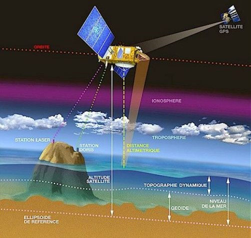
Contents: along-track altimetric measurements at 20 Hz, corrections to apply, in near-real time made from Jason-2 S-IGDR altimeter products with specific processing, developed by CLS in the framework of the Pistach project.
This first version adopts the same format and structure as Jason-2 standard IGDR to facilitate their appropriation by expert users. Most of the scientifical/technological content of the official Jason-2 IGDR is included (variable names are unchanged). Extra fields derived from the various Pistach processes are then added to the products. Simpler products are also delivered for a wider dissemination (see the regional CoastalDT-SLA product).
Use: coastal applications, operational oceanography (near-real time), environmental monitoring (flooding/drought)
Description: specific product for coastal and continental waters including dedicated processing (retracking of the waveforms) and corrections (wet and dry tropospheric corrections, ...). Improvements of conventional satellite radar altimetry products over these areas lead to more accurate data near the coasts and inland waters.
Users should keep in mind that these products are experimental products. Notably, they are not produced on an operational basis. They are freely distributed without any warranty of any kind.
Geographic coverage: Coastal areas include all oceans and a band 25 km wide over land. Hydrology products include all continents and a band 25 km over oceans.
Metadata
- File identifier
- 212d6f41-ee85-4887-b27e-6f77965c5f7c
- Metadata language
- Français
- Other language
-
Language Character encoding English UTF8
- Character set
- UTF8
- Hierarchy level
- Dataset
- Date stamp
- 2021-09-24T14:03:25
- Metadata standard name
-
ISO 19115:2003/19139 - SEXTANT
- Metadata standard version
-
1.0
accessData
Overviews
)))