Physical environment - Sedimentary cover of the English Channel done by Larsonneur and collaborators.
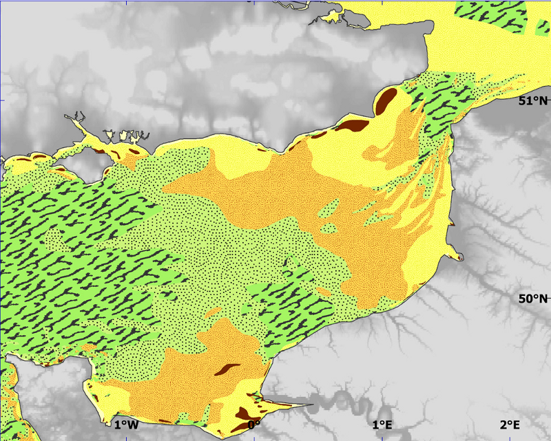
The map presented in the atlas is derived from the so-called "Larsonneur map" (Larsonneur et al., 1979). This later was created using data available in 1977 (around 12,000 samples, plus additional information derived from British publications, navigation charts, rock coring and seismic profiles necessary to determine the occurence and the spatial extent of rock outcrops). Each sampled station was assigned a sediment type based on its granulometry and its calcium carbonate content, resulting in 48 possible seabed types, though 3 were not found in the English Channel. Seabed sediment types could also be classified into four main categories (pebble, gravel, sand and mud) based on their granulometry. These criteria enhanced the importance of smaller particles on one hand, and of coarse particles on the other, which both determine the physical and chemical properties of the deposits and hence the biotopic characteristics. Used as layer for habitat.
Simple
- Title
-
Physical environment - Sedimentary cover of the English Channel done by Larsonneur and collaborators.
- Alternate title
-
Larsonneur_environment_digitize
- Date (Publication)
- 2009-12-31T00:00:00
- Citation identifier
- CHARM_SEDIM_LARSONNEUR_P
- Presentation form
- Digital map
- Other citation details
-
Source CHARM Consortium
- Abstract
-
The map presented in the atlas is derived from the so-called "Larsonneur map" (Larsonneur et al., 1979). This later was created using data available in 1977 (around 12,000 samples, plus additional information derived from British publications, navigation charts, rock coring and seismic profiles necessary to determine the occurence and the spatial extent of rock outcrops). Each sampled station was assigned a sediment type based on its granulometry and its calcium carbonate content, resulting in 48 possible seabed types, though 3 were not found in the English Channel. Seabed sediment types could also be classified into four main categories (pebble, gravel, sand and mud) based on their granulometry. These criteria enhanced the importance of smaller particles on one hand, and of coarse particles on the other, which both determine the physical and chemical properties of the deposits and hence the biotopic characteristics. Used as layer for habitat.
- Credit
-
Larsonneur, C., Vaslet, D. & Auffret, J.P., 1979. Les sédiments superficiels de la Manche, Carte géologique de la Marge continentale française. Bureau des recherches géologiques et Minières, Ministère de l'Industrie, Service Géologique National, Orléans.
- Credit
-
CHARM consortium
- Status
- Completed
- Point of contact
-
Organisation name Individual name Electronic mail address Role Ifremer
CHARM consortium
Local service desk
- Maintenance and update frequency
- As needed
-
Thèmes Sextant
-
-
/Physical Environment/Geology/Mineral Resources
-
- Discipline
-
-
Sedimentology
-
CHARM
-
-
GEMET - INSPIRE themes, version 1.0
-
-
Geology
-
-
external.theme.gemet
-
-
sédimentologie
-
- Use limitation
-
research-only
- Access constraints
- License
- Other legal constraints
-
Has to be cited this way in maps : "Source CHARM Consortium"
- Other legal constraints
-
Has to be cited this way in bibliography : "Carpentier A, Martin CS, Vaz S (Eds.), 2009. Channel Habitat Atlas for marine Resource Management, final report / Atlas des habitats des ressources marines de la Manche orientale, rapport final (CHARM phase II). INTERREG 3a Programme, IFREMER, Boulogne-sur-mer, France. 626 pp. & CD-rom"
- Spatial representation type
- Vector
- Denominator
- 1000
- Language
- Français
- Language
- English
- Character set
- UTF8
- Topic category
-
- Geoscientific information
- Imagery base maps earth cover
- Environment
- Environment description
-
Microsoft Windows XP ; ESRI ArcGIS 9.x
- Geographic identifier
- Eastern English Channel
))
- Begin date
- 1970-01-01
- End date
- 1977-12-31
- Reference system identifier
- 4326
- Topology level
- Geometry only
- Geometric object type
- Surface
- Geometric object count
- 1475
Distributor
- Distributor contact
-
Organisation name Individual name Electronic mail address Role Ifremer - Centre de Brest
Dissemination Unit
- Distributor format
-
Name Version
- OnLine resource
-
Protocol Linkage Name OGC:WMS
https://sextant.ifremer.fr/services/wms/wms_charm? CHARM_SEDIM_LARSONNEUR_P
COPYFILE
CHARM_SEDIM_LARSONNEUR_P
WWW:LINK
http://www.ifremer.fr/charm/
- Hierarchy level
- Dataset
- Statement
-
Compilation of samples of different scientific surveys done by Larsonneur and other scientists
- Description
-
The Larsonneur paper chart was digitised (by IFREMER) as an ArcMap compatible shapefile. Then, it has been reclassified in five categories, based on granulometry (pebble, gravel, coarse sand, fie sand and mud). Finally, it has been cut to the size of CHARM's study area using ArcMap's Geoprocessing wizard.
- Description
-
Scientific surveys of Marine geology laboratories of Caen, Rouen, Rennes, Bureau de Recherches Géologiques et Minières (BRGM), Marine biology laboratory of de Roscoff ; geography and geomorphology laboratories of Brest, Caen, Dinard ; laboratoire central
Metadata
- File identifier
- 221bd620-fc7f-11df-abec-005056987263
- Metadata language
- English
- Character set
- UTF8
- Hierarchy level
- Dataset
- Date stamp
- 2024-04-05T09:31:36.038Z
- Metadata standard name
-
ISO 19115:2003/19139 - SEXTANT
- Metadata standard version
-
1.0
- Metadata author
-
Organisation name Individual name Electronic mail address Role Ifremer
Sandrine Vaz
Local service desk
accessData
Overviews
)))