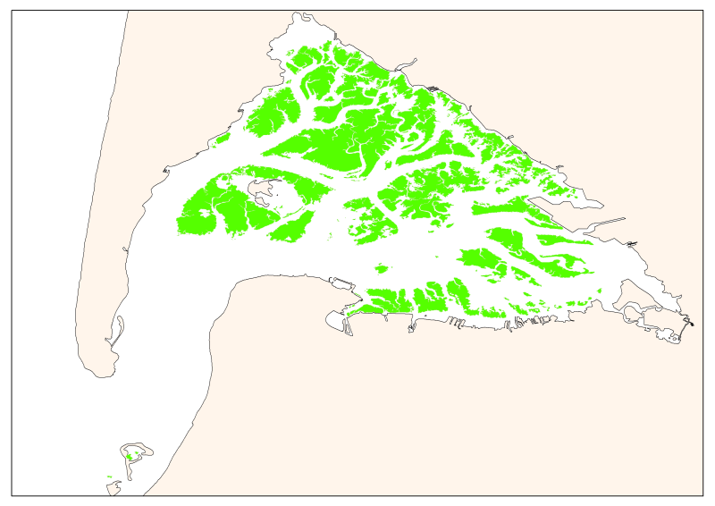
Beds of Zostera noltii seagrass of Arcachon 2008
Map of the maximum extent of the seagrass Zostera noltti of Arcachon acquired in 2007-2008, under the supervisory control of the WFD (EU Water Framework Directive). Funded by the AEAG (Agence de l'Eau Adour Garonne) and Ifremer.
Simple
- Title
-
Beds of Zostera noltii seagrass of Arcachon 2008
- Date (Creation)
- 2008-01-15
- Date (Publication)
- 2010-01-18
- Citation identifier
- ArcachonNoltii2008_wgs84.shp
- Abstract
-
Map of the maximum extent of the seagrass Zostera noltti of Arcachon acquired in 2007-2008, under the supervisory control of the WFD (EU Water Framework Directive). Funded by the AEAG (Agence de l'Eau Adour Garonne) and Ifremer.
- Credit
-
Ifremer
- Point of contact
-
Organisation name Individual name Electronic mail address Role IFREMER
Trut Gilles
Local service desk
-
Thèmes Sextant
-
-
/Biological Environment/Key Habitats/Seagrass
-
- Theme
-
-
Zostera noltii
-
Specific biocenosis habitats of mesolittoral zones
-
-
GEMET - INSPIRE themes, version 1.0
-
-
Habitats and biotopes
-
- Place
-
-
Arcachon
-
-
Sous-regions marines
-
-
Bay of Biscay
-
- Access constraints
- Copyright
- Use constraints
- Copyright
- Other legal constraints
-
no restrictions on public access
- Classification
- Unclassified
- Spatial representation type
- Vector
- Denominator
- 5000
- Language
- Français
- Character set
- UTF8
- Topic category
-
- Biota
- Environment
- Geoscientific information
))
- Begin date
- 2007-08-01T16:51:00
- End date
- 2008-07-31T16:51:00
- Reference system identifier
- EPSG / WGS84 géographiques / 7.4
- Distribution format
-
Name Version shape ESRI
ArcGIS 9.3.1
- OnLine resource
-
Protocol Linkage Name WWW:LINK
http://wwz.ifremer.fr/dcsmm site internet Ifremer dédié à la Directive Cadre Stratégie pour le Milieu Marin
WWW:LINK
http://www.ifremer.fr/sextant/fr/web/dcsmm/223c_biocenoses_habitats_particuliers_mediolittoral carthothèque DCSMM
- OnLine resource
-
Protocol Linkage Name WWW:LINK
http://www.ifremer.fr/delar/sig.htm
- Hierarchy level
- Dataset
- Statement
-
Interpretation of an IGN (l’institut national de l’information géographique et forestière) Orthophoto (August 2007 - 50 cm resolution) supplemented by field validation conducted between August and October 2007 and July 2008. Breakdown obtained depending on the recovery rate of the grass bed. Three groups covering high-medium-low. Information on the reliability of the data depends on whether the field validation was performed or not.
Metadata
- File identifier
- 22eba766-1d2a-4497-9c04-74029a4c2336
- Metadata language
- Français
- Other language
-
Language Character encoding English
- Character set
- UTF8
- Hierarchy level
- Dataset
- Hierarchy level name
-
Jeu de données
- Date stamp
- 2020-06-04T00:36:01
- Metadata standard name
-
ISO 19115:2003/19139 - SEXTANT
- Metadata standard version
-
1.0
- Metadata author
-
Organisation name Individual name Electronic mail address Role IFREMER
Trut Gilles
Local service desk
accessData
Overviews
)))