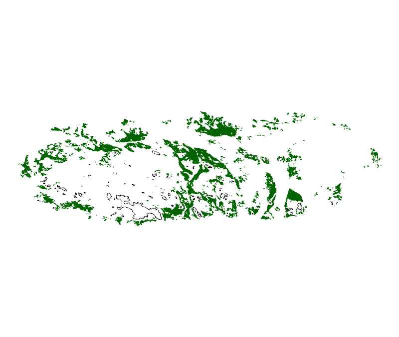
Map of Zostera marina seagrass in the Chausey archipelago. Status for 2002-2004.
Map of polygons, of Zostera marina seagrass (external and internal contours) of the Chausey archipelago determined from photo-detection, photo-identification and photo-interpretation and field checks (2002-2004) .
Simple
- Title
-
Map of Zostera marina seagrass in the Chausey archipelago. Status for 2002-2004.
- Alternate title
-
SIMON_herbierChauseyFournier04_P.shp
- Alternate title
-
DIREN_BN_ZOSTERA_MARINA_MSM_P
- Date (Creation)
- 2002-11-01T00:00:00
- Date (Publication)
- 2003-01-01T00:00:00
- Date (Revision)
- 2004-07-01T00:00:00
- Citation identifier
- DIREN_BN_ZOSTERA_MARINA_MSM_P
- Presentation form
- Digital map
- Abstract
-
Map of polygons, of Zostera marina seagrass (external and internal contours) of the Chausey archipelago determined from photo-detection, photo-identification and photo-interpretation and field checks (2002-2004) .
- Purpose
-
The work was done at the request of the DIREN of Basse-Normandie (the Lower Normandy region) and with the objective of mapping phanerogams of the Chausey archipelago; two species of seagrass were involved, Zostera marina and Zostera noltii. Therefore another data set exists for the latter.
- Status
- Completed
- Point of contact
-
Organisation name Individual name Electronic mail address Role Station Marine de Dinard - UMR 5178 BOME CNRS/Muséum National d'Histoire Naturelle
Jérôme FOURNIER
Local service desk Station Marine de Dinard - UMR 5178 BOME CNRS/Muséum National d'Histoire Naturelle
Jérôme FOURNIER
Principal investigator DIREN Basse-Normandie
DIREN Basse-Normandie
Owner DIREN Basse-Normandie
DIREN Basse-Normandie
Product manager Laboratoire de Géomorphologie et Environnement littoral - UMR 8586 CNRS PRODIG
Chantal BONNOT-COURTOIS
Processor Université de Rennes 2
Alain DREAU
Processor Laboratoire de Géomorphologie et Environnement littoral - Ecole Pratique des Hautes Etudes
Hélène GLORIA
Processor Institut Universitaire et Européen de la Mer
Françoise GOURMELON
Processor Institut Universitaire et Européen de la Mer
Christian HILY
Processor IFREMER
Brigitte GUILLAUMONT
Processor DIREN Basse-Normandie
Sandrine ROBBE
Local service desk
- Maintenance and update frequency
- Unknown
-
Thèmes Sextant
-
-
/Biological Environment/Key Habitats/Seagrass
-
- Theme
-
-
seagrass
-
Zostera
-
phanerogams
-
- Place
-
-
Chausey
-
English Channel
-
Lower Normandy
-
Normano-Breton Gulf
-
-
GEMET - INSPIRE themes, version 1.0
-
-
Habitats and biotopes
-
-
Sous-regions marines
-
-
Channel-North Sea
-
Celtic Seas
-
- Use limitation
-
Commercial use is prohibited.
- Access constraints
- Other restrictions
- Use constraints
- Copyright
- Other legal constraints
-
Citation for the map is required with the following reference : "Source - Owner: DIREN Basse-Normandie. Prepared by : FOURNIER et al., 2004. Carte des herbiers de phanérogames marines de l'archipel de Chausey. UMR 8586 CNRS PRODIG/Laboratoire de Géomorphologie et Environnement littoral/EPHE".
- Other legal constraints
-
Citation in the bibliography is required with the following reference : "FOURNIER J., 2003. Cartographie des herbiers de phanérogames marines de l'archipel de Chausey. Rapport pour la DIREN Basse-Normandie, 35p. UMR 8586 CNRS PRODIG/Laboratoire de Géomorphologie et Environnement littoral/EPHE."
- Spatial representation type
- Vector
- Denominator
- 10000
- Language
- Français
- Character set
- UTF8
- Topic category
-
- Biota
- Oceans
- Environment
- Description
-
Période couverte par les missions de terrain
- Begin date
- 2002-04-01T16:26:00
- End date
- 2004-04-01T16:27:00
- Description
-
Date de prise de vue de la photographie aérienne
))
- Supplemental Information
-
This work was carried out by the Dinard laboratory of geomorphology with the help of the University of Rennes 2 and Geneva, the IGN, the ENSG, the l'Institut Universitaire Européen de la Mer (European University Institute and the Sea), and IFREMER, at the request of the DIREN. On the terrain, 80% of seagrass were verified. Scanning was performed at a scale of 1/1000.
- Reference system identifier
- 4326
- Topology level
- Geometry only
- Geometric object type
- Surface
- Geometric object count
- 4441
Distributor
- Distributor contact
-
Organisation name Individual name Electronic mail address Role Ifremer
Dissemination Unit
- Distributor format
-
Name Version ESRI Shapefile
1.0
- OnLine resource
-
Protocol Linkage Name OGC:WMS
https://sextant.ifremer.fr/services/wms/biologie DIREN_BN_ZOSTERA_MARINA_MSM_P
- Hierarchy level
- Dataset
- Statement
-
This map was produced from aerial photograph analysis (13/08/02) associated with field validation (2002-2004)
- Description
-
- AERIAL PHOTOGRAPH MOSAICKING AND REFERENCING - Data sources are aerial photographs of the mission DIREN / IGN 2002 EN 5539/100 C 13/08/02. These photographs were taken at 1:10,000 scale. They were digitized using a photogrammetric scanner at high resolution and then processed in order to use them. The method used is as follows: read and import the digital data, display the images then evaluation and correction of the images, create a mosaic of the images, color balance of the mosaic, backup the data and finally compression in ECW format.
- Description
-
- ANALYSIS OF AERIAL PHOTOGRAPHS - The data were transferred to ArcView (ESRI) to generate polygons (digitization of internal and external contours). Three techniques were used for mapping seagrasses: photo-identification (simple reading of the photograph), the photo-determination (intuition and deduction of the interpreter), and finally, the photo-interpretation (assumptions recreating relations between certain components of the image).
- Description
-
- VALIDATION OF THE TERRAIN - The control testing of the hypotheses of the terrain was carried out from the end of April 2002 and continued regularly. In July 2004, 80% of the map polygons were checked in the field. The polygons in the northern sector of the archipelago were not validated.
- Description
-
- GENERALIZATION - The last step was to generalize the field validations (80% polygons) of the entire map.
- Description
-
- DATA PROCESSING – The data was validated in terms of geometric and attribute using a defined protocol for the GIS marine Bay of Mont Saint-Michel and using ArcGIS 9.2 (ESRI). The following operations were performed: realignment of field names, transformation of multi-party entities in one part (with ArcToolbox), the use of the ArcInfo topological correction tool to eliminate discontinuity and superposition errors, verification of geometric errors (ArcToolbox).
Content Information
Metadata
- File identifier
- 26c165e0-a27e-11dc-a322-000086f6a603
- Metadata language
- Français
- Other language
-
Language Character encoding English
- Character set
- UTF8
- Hierarchy level
- Dataset
- Date stamp
- 2020-06-04T00:40:08
- Metadata standard name
-
ISO 19115:2003/19139 - SEXTANT
- Metadata standard version
-
1.0
- Metadata author
-
Organisation name Individual name Electronic mail address Role IFREMER
Xavier ROZEC
Local service desk
accessData
Overviews
)))