Spatial distribution of the crepidula (Crepidula fornicata) in the bay of Brest between 2013 and 2018
Monitoring the spatial distribution of crepidula (Crepidula fornicata) between 2013 and 2018 using underwater video and grab samples in the Bay of Brest
Simple
- Title
-
Spatial distribution of the crepidula (Crepidula fornicata) in the bay of Brest between 2013 and 2018
- Date (Publication)
- 2023-02-28
- Date (Creation)
- 2023-02-13
- Date (Revision)
- 2023-07-17
- Citation identifier
- https://sextant.ifremer.fr/geonetwork/276dab32-7db7-420c-acd1-d61a56ec378d
- Abstract
-
Monitoring the spatial distribution of crepidula (Crepidula fornicata) between 2013 and 2018 using underwater video and grab samples in the Bay of Brest
- Credit
-
Ifremer, DYNECO, F-29280 Plouzané, France / REBENT, EC2CO-DRIL "Evocrep", H2020 JERICO-Next projects
- Point of contact
-
Organisation name Individual name Electronic mail address Role IFREMER
Carlier Antoine
Author IFREMER
Androuin Thibault
Author IFREMER
Caisey Xavier
Author IFREMER
Cordier Celine
Author IFREMER
Gaffet Jean-Dominique
Author IFREMER
Perier Vincent
Author IUEM
Grall Jacques
Author IFREMER
Carlier Antoine
Local service desk Ifremer, DYNECO, F‐29280 Plouzané, France
Publisher
-
Thèmes Sextant
-
-
/Biological Environment/Habitats
-
-
GEMET - INSPIRE themes, version 1.0
-
-
Habitats and biotopes
-
- Access constraints
- Other restrictions
- Use constraints
- Copyright
- Other legal constraints
-
Obligation to quote:
Carlier Antoine, Androuin Thibault, Caisey Xavier, Cordier Céline, Gaffet Jean-Dominique, Perier Vincent, Grall Jacques (2023). Spatial distribution of the crepidula (Crepidula fornicata) in the bay of Brest between 2013 and 2018. Ifremer, DYNECO, F‐29280 Plouzané, France. https://doi.org/10.12770/276dab32-7db7-420c-acd1-d61a56ec378d
- Association Type
- Cross reference
- Initiative Type
- Platform
- Association Type
- Cross reference
- Initiative Type
- Platform
- Association Type
- Cross reference
- Initiative Type
- Platform
- Association Type
- Cross reference
- Initiative Type
- Platform
- Association Type
- Cross reference
- Initiative Type
- Platform
- Association Type
- Cross reference
- Initiative Type
- Platform
- Spatial representation type
- Vector
- Denominator
- 25000
- Language
- Français
- Character set
- UTF8
- Topic category
-
- Oceans
))
- Begin date
- 2013-03-01
- End date
- 2018-04-25
- Unique resource identifier
- EPSG:2154
- Geometric object type
- Complex
- Distribution format
-
Name Version
- OnLine resource
-
Protocol Linkage Name OGC:WMS
https://sextant.ifremer.fr/services/wms/dyneco RDB_crepidules_stations_2013_2018
- OnLine resource
-
Protocol Linkage Name OGC:WMS
https://sextant.ifremer.fr/services/wms/dyneco RDB_crepidules_contours_2013_2018
- OnLine resource
-
Protocol Linkage Name DOI
https://doi.org/10.12770/276dab32-7db7-420c-acd1-d61a56ec378d Digital Object Identifier (DOI)
- Hierarchy level
- Dataset
Conformance result
- Title
-
RÈGLEMENT (UE) N o 1089/2010 DE LA COMMISSION du 23 novembre 2010 portant modalités d'application de la directive 2007/2/CE du Parlement européen et du Conseil en ce qui concerne l'interopérabilité des séries et des services de données géographiques
- Date (Publication)
- 2010-12-08
- Explanation
-
See the referenced specification
- Statement
-
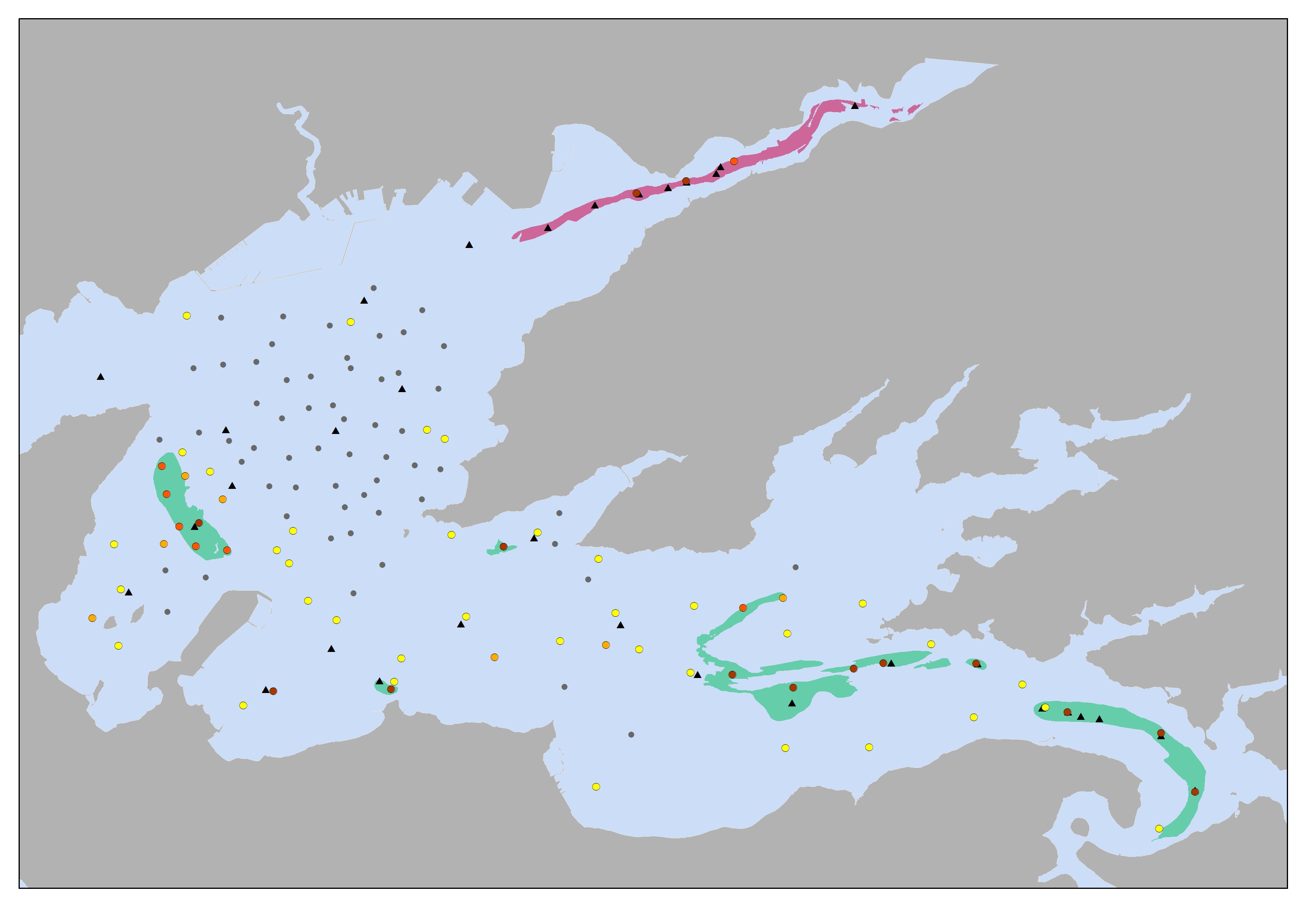
The spatial distribution of the crepidula (Crepidula fornicata) in the bay of Brest was studied as part of the national EC2CO-DRIL project (2013-2015) and the European JERICO-Next project (2015-2019). The aim was to draw up an inventory of the ecological status of the population of this invasive gastropod over the period 2013-2018, after a 30-year phase of proliferation that led to a very high biomass spread over half the surface area of the bay. As this species is gregarious and considered to be an "ingenious" species, it strongly structured the benthic communities and habitats during its expansion in the 1990s, forming very extensive shoals with several thousand individuals per square metre in places. Following several signals of decline recorded in the early 2000s, the aim was to examine the evolution of this habitat in terms of geographical distribution, vitality, density and biomass. Thanks to several campaigns of quantitative sampling, sonar imagery and underwater imagery, carried out using a suspended video frame (2013) and a towed video device (2016 and 2018), the decline of the crepidula has been clearly demonstrated throughout the southern part of the bay of Brest.
The data is separated into 2 distinct layers:
- The "stations" layer groups together all the direct observations (grab samples and photo-videos) and their analysis results (presence, densities, biomass).
Grab samples (Smith; 0.1 m²) were sieved through a 2 mm mesh and yielded quantitative data on densities (in number of individuals/m²) and biomass (in g of fresh weight, with shell/m²).
Deployment of the suspended video camera and the towed photo-video device provided qualitative data (presence/absence; vitality, living/dead) and semi-quantitative data (% cover on the seabed; number of chains of living individuals visible on the seabed). The data on % cover on the seabed was determined according to 5 classes of cover (0 % in the absence of crepidulids; 1 to 25 % of the image surface; 26 to 50 %; 51 to 75 %; 76 to 100 %).
With the suspended video frame, the surface area filmed when the frame is laid flat on the bottom is 0.05 m². At each station, around twenty video captures were recorded when the frame was placed on the bottom, representing a total of almost 1 m². Coverage classes are estimated independently for each capture, then averaged over the whole station.
With the towed video camera, the area photographed vertically from the camera was 0.29 m², and a photo was recorded every 10 seconds along the entire transect. As with the suspended video camera, the coverage classes are estimated independently for each photo. The level of vitality of the crepidulas (proportion of living individuals among the visible crepidulas) is estimated on each photo according to 5 classes from 0 to 4 (0: all the visible crepidulas are dead; 2: half the visible crepidulas are alive; 4: all the visible crepidulas are alive).
- The "contours" layer shows the location and limits of the main banks of crepidula (live or dead) present in the bay of Brest, with a coverage of more than 50%. The contours were drawn manually using sonar data from the REB-RAD-H-2013 campaign (https://doi.org/10.17600/13120090) and observation data. The contours of the banks partly follow the sedimentary limits of the map by Gregoire et al (2016)*.
* Gwendoline Gregoire, Axel Ehrhold, Pascal Le Roy, Gwenael Jouet & Thierry Garlan (2016) Modern morpho-sedimentological patterns in a tide-dominated estuary system: the Bay of Brest (west Britanny, France), Journal of Maps, 12:5, 1152-1159, DOI: 10.1080/17445647.2016.1139514
- Description
-
Update on 13/07/2023: Data from the Pagure video towed vehicle added to the station layer
- Feature catalogue citation
Metadata
- File identifier
- 276dab32-7db7-420c-acd1-d61a56ec378d
- Metadata language
- Français
- Other language
-
Language Character encoding English UTF8
- Character set
- UTF8
- Hierarchy level
- Dataset
- Date stamp
- 2023-10-26T12:57:15.518Z
- Metadata standard name
-
ISO 19115:2003/19139 - SEXTANT
- Metadata standard version
-
1.0
- Metadata author
-
Organisation name Individual name Electronic mail address Role IFREMER
Cordier Celine
Local service desk
)))