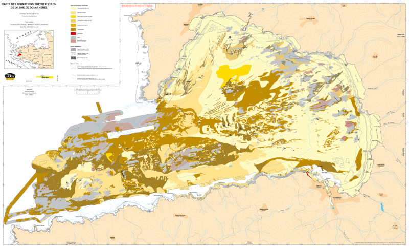
Formations superficielles de la baie de Douarnenez (2005), scan géoréférencé
Scan géoréférencé de la carte des formations superficielles de la baie de Douarnenez, éditée en 2005 dans l'atlas thématique de l'environnement marin de la baie de Douarnenez.
Les campagnes océanographiques à l'origine de la réalisation de cette carte sont :
- AUGRIS Claude, NORMAND Alain (2000) CANADOU cruise, RV Thalia, https://doi.org/10.17600/70020
- APPRIOUAL Ronan, BLANCHET-AURIGNY Aline (2001) CANADOU cruise, RV Thalia, https://doi.org/10.17600/1070050
- APPRIOUAL Ronan, BLANCHET-AURIGNY Aline (2001) CANADOU 2 cruise, RV Thalia, https://doi.org/10.17600/1070080
- AUGRIS Claude, MOUQUET Alain (2001) CANADOU RESON 2001 cruise, RV Unknown. https://campagnes.flotteoceanographique.fr/campagnes/1000010/
Référence bibliographique : AUGRIS C., MENESGUEN A., HAMON D., BLANCHET A., LE ROY P., ROLET J., JOUET G., VERON G., DELANNOY H., DROGOU M., BERNARD C., MAILLARD X. (2005), Atlas thématique de l'environnement marin de la baie de Douarnenez (Finistère). 10 cartes, échelle 1/25 000 et un livret d'accompagnement, 135 p. Ed. Ifremer - Ville de Douarnenez. Ce jeu de données correspond à la carte des formations superficielles de l'atlas.
Simple
- Title
-
Formations superficielles de la baie de Douarnenez (2005), scan géoréférencé
- Date (Publication)
- 2005-01-01T00:00:00
- Edition
-
carte papier, édition Ifremer
- Edition date
- 2005-01-01T00:00:00
- Citation identifier
- FR-330-715-368-00032-FormationsSup_BaieDouarnenez_Augris_2005_ScanGeoref
- Citation identifier
- DOI:10.12770/2ad53d80-bb50-11df-a9b6-005056987263
- Presentation form
- Digital map
- ISBN
-
2-84433-139-4
- Abstract
-
Scan géoréférencé de la carte des formations superficielles de la baie de Douarnenez, éditée en 2005 dans l'atlas thématique de l'environnement marin de la baie de Douarnenez.
Les campagnes océanographiques à l'origine de la réalisation de cette carte sont :
- AUGRIS Claude, NORMAND Alain (2000) CANADOU cruise, RV Thalia, https://doi.org/10.17600/70020
- APPRIOUAL Ronan, BLANCHET-AURIGNY Aline (2001) CANADOU cruise, RV Thalia, https://doi.org/10.17600/1070050
- APPRIOUAL Ronan, BLANCHET-AURIGNY Aline (2001) CANADOU 2 cruise, RV Thalia, https://doi.org/10.17600/1070080
- AUGRIS Claude, MOUQUET Alain (2001) CANADOU RESON 2001 cruise, RV Unknown. https://campagnes.flotteoceanographique.fr/campagnes/1000010/
Référence bibliographique : AUGRIS C., MENESGUEN A., HAMON D., BLANCHET A., LE ROY P., ROLET J., JOUET G., VERON G., DELANNOY H., DROGOU M., BERNARD C., MAILLARD X. (2005), Atlas thématique de l'environnement marin de la baie de Douarnenez (Finistère). 10 cartes, échelle 1/25 000 et un livret d'accompagnement, 135 p. Ed. Ifremer - Ville de Douarnenez. Ce jeu de données correspond à la carte des formations superficielles de l'atlas.
- Credit
-
Ifremer / Ville de Douarnenez
- Status
- Completed
- Point of contact
-
Organisation name Individual name Electronic mail address Role Ifremer
Ifremer Géosciences Marines
Local service desk Ifremer
AUGRIS Claude
Author Ifremer
Ifremer
Publisher Intechmer
DELANNOY Hélène
Author Ifremer
MAZE Jean-Pierre
Author
- Maintenance and update frequency
- Not planned
-
Thèmes Sextant
-
-
/Cartes scannées/Ifremer/Sédimentologie
-
-
GEMET - INSPIRE themes, version 1.0
-
-
Géologie
-
-
external.theme.gemet
-
-
sédiment marin
-
fond marin
-
- Theme
-
-
formations superficielles
-
natures des fonds
-
- Place
-
-
Douarnenez
-
Bretagne
-
Finistère
-
- Discipline
-
-
géophysique
-
sédimentologie
-
-
Ocean Hackathon - Ville
-
-
Brest
-
-
GEMET - Concepts, version 2.4
-
-
morphologie sous-marine
-
fond marin
-
- Use limitation
-
CC BY. Licence Creative Commons Attribution 4.0 International https://creativecommons.org/licenses/by/4.0/
- Access constraints
- Other restrictions
- Use constraints
- License
- Other legal constraints
-
Pas de restriction d'accès public.
- Other legal constraints
-
Proposition de citation : AUGRIS C., DELANNOY H., MAZE J. P. (2005) - Carte des formations superficielles de la baie de Douarnenez (Finistère). Echelle 1/25 000. Ed. Ifremer - Ville de Douarnenez.
- Aggregate Datasetindentifier
- 388cf670-c262-11df-a9b6-005056987263
- Association Type
- Cross reference
- Aggregate Datasetindentifier
- ed9ccebe-d745-468e-8f51-819c839edfb8
- Association Type
- Cross reference
- Spatial representation type
- Grid
- Denominator
- 25000
- Language
- Français
- Character set
- UTF8
- Topic category
-
- Geoscientific information
))
- Description
-
Période d'acquisition des données
- Begin date
- 2000-05-12
- End date
- 2001-09-06
- Reference system identifier
- EPSG / ED50 (EPSG:4230) / 7.4
- Number of dimensions
- 2
- Dimension name
- Column
- Dimension size
- 7059
- Dimension name
- Row
- Dimension size
- 2863
- Cell geometry
- Area
- Transformation parameter availability
- Distribution format
-
Name Version TIFF
- Distributor contact
-
Organisation name Individual name Electronic mail address Role Ifremer - centre de Brest
Dissemination Unit
- OnLine resource
-
Protocol Linkage Name OGC:WMS
https://sextant.ifremer.fr/services/wms/gm_geologie FormationsSup_BaieDouarnenez_Augris_2005_ScanGeoref
COPYFILE
FormationsSup_BaieDouarnenez_Augris_2005_ScanGeoref
WWW:LINK-1.0-http--metadata-URL
http://dx.doi.org/10.12770/2ad53d80-bb50-11df-a9b6-005056987263 DOI du jeu de donnée
- OnLine resource
-
Protocol Linkage Name WWW:LINK
http://dx.doi.org/10.17600/70020 Campagne CANADOU (2000)
WWW:LINK
http://dx.doi.org/10.17600/1070050 Campagne CANADOU (2001)
WWW:LINK
http://dx.doi.org/10.17600/1070080 Campagne CANADOU 2
WWW:LINK
http://campagnes.flotteoceanographique.fr/campagnes/1000010/ Campagne CANADOU RESON 2001
- Hierarchy level
- Dataset
Conformance result
- Title
-
INSPIRE
- Date (Publication)
- 2007-03-14
- Explanation
-
Non évalué
- Pass
- Statement
-
Carte originale papier scannée et géoréférencée.
Metadata
- File identifier
- 2ad53d80-bb50-11df-a9b6-005056987263
- Metadata language
- Français
- Character set
- UTF8
- Hierarchy level
- Dataset
- Date stamp
- 2023-05-23T09:49:15.076Z
- Metadata standard name
-
ISO 19115:2003/19139 - SEXTANT
- Metadata standard version
-
1.0
- Metadata author
-
Organisation name Individual name Electronic mail address Role Ifremer
Géosciences Marines
Local service desk
accessData
Overviews
)))