Mean Sea Surface
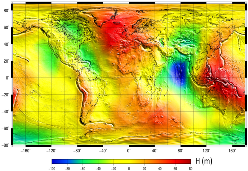
The mean sea surface (MSS) is an important field in physical oceanography, geophysics, and geodesy. In principle, it corresponds to the time-averaged height of the ocean surface.
Auxiliary product : mean sea profile above a reference ellipsoid (T/P or WSG84). This surface is available on a regular grid (1/60°x1/60°, 1 minute). Another grid provides the estimation of error fields which represent the MSS accuracy estimated through the inverse technique.
Simple
- Title
-
Mean Sea Surface
- Date (Creation)
- 2022-06-15
- Date (Publication)
- 2022-06-15
- Abstract
-
The mean sea surface (MSS) is an important field in physical oceanography, geophysics, and geodesy. In principle, it corresponds to the time-averaged height of the ocean surface.
Auxiliary product : mean sea profile above a reference ellipsoid (T/P or WSG84). This surface is available on a regular grid (1/60°x1/60°, 1 minute). Another grid provides the estimation of error fields which represent the MSS accuracy estimated through the inverse technique.
- Credit
-
AVISO+
- Point of contact
-
Organisation name Individual name Electronic mail address Role AVISO+
AVISO+
Local service desk AVISO+
Publisher
-
Centre de données ODATIS
-
-
CDS-SAT-AVISO
-
- Keywords
-
-
Thématique Produits auxiliaires altimétriques
-
Type de jeux de donnée ODATIS
-
-
/Processed data/Composite products
-
-
Thèmatiques ODATIS
-
-
Remote sensing
-
Added-value products
-
-
ODATIS aggregation parameters and Essential Variable names
-
-
Sea surface height
-
- Access constraints
- Other restrictions
- Use constraints
- Other restrictions
- Other legal constraints
-
Citation : Any use of this dataset must cite its reference: https://doi.org/10.24400/527896/a01-2022.017
The generation of the CNES_CLS 2022 MSS model was funded by CNES in the framework of the SWOT and SALP projects
- Spatial representation type
- Grid
- Distance
- 1 minute
- Language
- Français
- Character set
- UTF8
- Topic category
-
- Oceans
))
- Begin date
- 1993-01-01
- Geometric object type
- Complex
- Distribution format
-
Name Version
- OnLine resource
-
Protocol Linkage Name WWW:LINK
http://www.aviso.altimetry.fr/en/data/products/auxiliary-products/mss.html Plus d'information sur AVISO+
WWW:LINK
ftp://LOGIN:PASSWORD@ftp-access.aviso.altimetry.fr/auxiliary/mss Accès authentifié aux données via FTP
OGC:WMS
https://dataterra:odatis@tds.aviso.altimetry.fr/thredds/wms/dataset-mss-cnes-cls15-global?service=WMS&version=1.3.0&request=GetCapabilities mss
WWW:DOWNLOAD-1.0-link--download
https://dataterra:odatis@tds-odatis.aviso.altimetry.fr/thredds/catalog/dataset-mss-cnes-cls22-global/mss_cnes_cls2022/catalog.html MSS CNES CLS
WWW:LINK-1.0-http--metadata-URL
https://doi.org/10.24400/527896/a01-2022.017 DOI dataset MSS
- Hierarchy level
- Dataset
- Statement
-
Use: geodesy, geophysics, oceanography (operational oceanography, modeling, ocean variability studies)
Description : product for 20-year reference period (1993-2012), based 29 years of altimetry data (mean profiles, geodetic mission and SLA) Topex/poseidon, ERS-2, GFO, Jason-1,Jason-2, Jason-3, Envisat, SARAL/AltiKa, Cryosat-2, Sentinel-3A&B. The use of several missions requires to readjust all missions between them. Thus, a reference mission is chosen and other missions are adjusted with this latest.
Geographic coverage: global (from 79.4°S to 88°N)
References :
Schaeffer, P., M.-I. Pujol, P. Veillard, Y. Faugere, Q. Dagneaux, G. Dibarboure, N. Picot, 2023: The CNES CLS 2022 Mean Sea Surface: Short Wavelength Improvements from CryoSat-2 and SARAL/AltiKa High-Sampled Altimeter Data. Remote Sens. 2023, 15, 2910. https://doi.org/10.3390/rs15112910
Schaeffer, P. , M.-I. Pujol, , Y. Faugère, P. Veillard, Q. Dagneaux, G. Dibarboure, N. Picot, 2022: MSS_CNES_CLS2022 , OSTST 2022, Venice, November 2022. https://ostst.aviso.altimetry.fr/fileadmin/user_upload/OSTST2022/Presentations/GEO2022-New_CNES_CLS_2022_mean_sea_surface.pdf
Metadata
- File identifier
- 2b9f3376-1009-4ebc-9d96-df27503f0d82
- Metadata language
- Français
- Other language
-
Language Character encoding English UTF8
- Character set
- UTF8
- Hierarchy level
- Dataset
- Date stamp
- 2024-05-02T13:33:08.056Z
- Metadata standard name
-
ISO 19115:2003/19139 - SEXTANT
- Metadata standard version
-
1.0
accessData
Overviews
)))