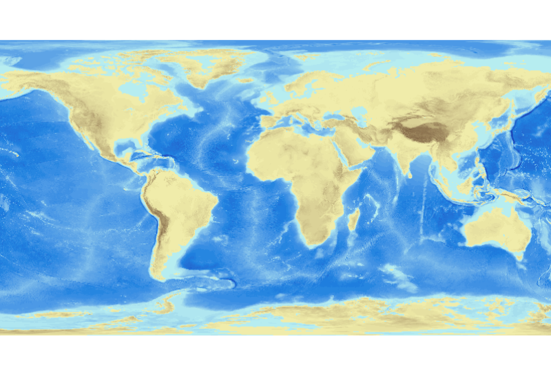
ETOPO1 1 Arc-Minute Global Relief Model
In August 2008, the National Geophysical Data Center (NGDC), an office of the National Oceanic and Atmospheric Administration (NOAA), developed the ETOPO1 Global Relief Model as an improvement to the ETOPO2v2 Global Relief Model. ETOPO1 is available in "Ice Surface" (top of Antarctic and Greenland ice sheets) and "Bedrock" (base of the ice sheets) versions. Both versions of ETOPO1 were generated from diverse global and regional digital data sets, which were shifted to common horizontal and vertical datums, and then evaluated and edited as needed. Bathymetric, topographic, and shoreline data used in ETOPO1 were obtained from NGDC, Antarctic Digital Database (ADD), European Ice Sheet Modeling Initiative (EISMINT), Scientific Committee on Antarctic Research (SCAR), Japan Oceanographic Data Center (JODC), Caspian Environment Programme (CEP), Mediterranean Science Commission (CIESM), National Aeronautics and Space Administration (NASA), National Snow and Ice Data Center (NSIDC), Scripps Institute of Oceanography (SIO), and Leibniz Institute for Baltic Sea Research (LIBSR). ETOPO1 is vertically referenced to sea level, and horizontally referenced to the World Geodetic System of 1984 (WGS 84). Cell size for ETOPO1 is 1 arc-minute.
Simple
- Title
-
ETOPO1 1 Arc-Minute Global Relief Model
- Alternate title
-
etopo1
- Date (Creation)
- 2008-09-03T13:52:00
- Citation identifier
- FRE-330-715-368-00032-ifr_etopo1_bedrock_mnt
- Presentation form
- Digital map
- Abstract
-
In August 2008, the National Geophysical Data Center (NGDC), an office of the National Oceanic and Atmospheric Administration (NOAA), developed the ETOPO1 Global Relief Model as an improvement to the ETOPO2v2 Global Relief Model. ETOPO1 is available in "Ice Surface" (top of Antarctic and Greenland ice sheets) and "Bedrock" (base of the ice sheets) versions. Both versions of ETOPO1 were generated from diverse global and regional digital data sets, which were shifted to common horizontal and vertical datums, and then evaluated and edited as needed. Bathymetric, topographic, and shoreline data used in ETOPO1 were obtained from NGDC, Antarctic Digital Database (ADD), European Ice Sheet Modeling Initiative (EISMINT), Scientific Committee on Antarctic Research (SCAR), Japan Oceanographic Data Center (JODC), Caspian Environment Programme (CEP), Mediterranean Science Commission (CIESM), National Aeronautics and Space Administration (NASA), National Snow and Ice Data Center (NSIDC), Scripps Institute of Oceanography (SIO), and Leibniz Institute for Baltic Sea Research (LIBSR). ETOPO1 is vertically referenced to sea level, and horizontally referenced to the World Geodetic System of 1984 (WGS 84). Cell size for ETOPO1 is 1 arc-minute.
- Credit
-
National Oceanic and Atmospheric Administration (USA)
- Status
- On going
- Point of contact
-
Organisation name Individual name Electronic mail address Role National Centers for Environmental Information (NCEI)
NOAA National Geophysical Data Center
Author
- Maintenance and update frequency
- As needed
-
Thèmes Sextant
-
-
/Physical Environment/Bathymetry/Digital Terrain Model
-
-
GEMET - INSPIRE themes, version 1.0
-
-
Elevation
-
-
Mission Atlantic - Resources
-
-
Data
-
-
Mission Atlantic - BODC Parameters
-
-
/Marine geology/Gravity, magnetics and bathymetry
-
-
Mission Atlantic - Data type (DMP)
-
-
Spatial data products
-
-
Mission Atlantic - Work Package
-
-
WP6 Dynamics of ecosystem state and resources
-
-
Mission Atlantic - Case Studies
-
-
Atlantic Ocean
-
- Access constraints
- Copyright
- Spatial representation type
- Grid
- Language
- Français
- Character set
- UTF8
- Topic category
-
- Oceans
))
- Begin date
- 1940-01-01
- End date
- 2008-01-01Before
- Reference system identifier
- EPSG / WGS 84 (EPSG:4326) / 7.4
- Number of dimensions
- 2
- Dimension name
- Vertical
- Dimension name
- Time
- Cell geometry
- Area
- Transformation parameter availability
- Distribution format
-
Name Version grid
- Distributor contact
-
Organisation name Individual name Electronic mail address Role Ifremer - Centre de Brest
Administrateur du serveur Sextant
Dissemination Unit
- OnLine resource
-
Protocol Linkage Name OGC:WMS
https://sextant.ifremer.fr/services/wms/wms1? ETOPO1_R
WWW:LINK
https://www.ngdc.noaa.gov/mgg/global/ ETOPO1 Global Relief Model
WWW:LINK-1.0-http--metadata-URL
doi:10.7289/V5C8276M DOI
- Hierarchy level
- Dataset
- Statement
-
- 2008-06-17T00:00:00 - All datasets obtained by NGDC were converted to common horizontal and vertical datums of WGS 84 and sea level, respectively, using FME. They were also converted to common file format, ESRI point shapefiles, for visualization and inspection.
- 2008-06-25T00:00:00 - Datasets were visually inspected with ArcGIS for identification and editing of data anomalies. Datasets were then compared with overlapping datasets to ensure data consistency.
- 2008-06-30T00:00:00 - Coastline datasets were adjusted to fit satellite imagery.
- 2008-07-10T00:00:00 - xyz files of the Measured and Estimated Seafloor Topography data (between -500 m and 0 m) were surfaced using GMT's 'surface' tool onto a 1 arc-minute cell size grid that interpolated to fill empty cells. Points extracted along the GSHHS coastline were also included, at -1 m elevation, to force bathymetric interpolation into the coastal zone. The resulting Arc ASCII grid was clipped to the coastline and the -120 m contour to remove values over land and non-coastal waters.
- 2008-07-18T00:00:00 - xyz files for each input dataset were gridded using MB-System's 'mbgrid' tool, which utilizes a high-tension spline interpolation method to fill grid cells with no input elevation values. Preferential weighting was given to the NSIDC Antarctica RAMP topography dataset. Least weight was given to the global datasets and the interpolated bathymetric surface. Gridding was performed in 16 regional tiles, each with a 5% data buffer. The grids were imported in ArcGIS and seamlessly merged to create the final global relief model.
- 2008-07-31T00:00:00 - ETOPO1 was bult as a global, grid-registered, 1 arc-minute grid that spans from pole to pole and from -180 degrees to 180 degrees in longitude. It is 21601 cells by 10801 cells in dimension, with multiple duplicate cells sitting atop the North and South poles and on the -180 degrees and 180 degrees longitude line. A cell-registered version (21600 by 10800 cells) was created from the grid-registered version by resampling, using GMT's 'grdsample' tool. This resampling introduces some flattening of relief, due to averaging of four grid-registered cell vlaues to produce one cell-registered value. Both types are global, though the grid-registered version should be considered the authoritative version. The cell-registered version may be more appropriate for creating maps and images.
Metadata
- File identifier
- 2ba54b4c-f242-4337-b8b6-92e77978700e
- Metadata language
- Français
- Other language
-
Language Character encoding English UTF8
- Character set
- UTF8
- Hierarchy level
- Dataset
- Date stamp
- 2023-11-17T17:58:40.908Z
- Metadata standard name
-
ISO 19115:2003/19139 - SEXTANT
- Metadata standard version
-
1.0
- Metadata author
-
Organisation name Individual name Electronic mail address Role IFREMER
Satra Le Bris Catherine
Local service desk
)))