Marine Mammals and Seabirds - Lagenorhynchus albirostris - Effort sightings (1995 - 2011)
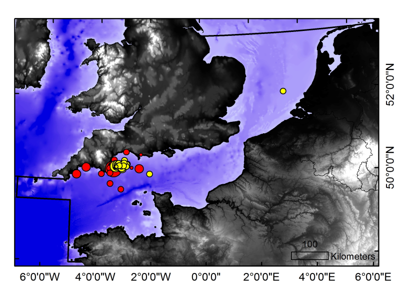
Effort sightings of Lagenorhynchus albirostris in the Channel Charm III sea zone based on MARINElife surveys between 1995-2011 at a 10km² resolution (effort sightings are indicated by yellow circles in the thumbnail, the red circles are casual sightings data, which are available in a separate data set).
Simple
- Title
-
Marine Mammals and Seabirds - Lagenorhynchus albirostris - Effort sightings (1995 - 2011)
- Date (Creation)
- Citation identifier
- ML034
- Other citation details
-
Source CHARM Consortium
- Abstract
-
Effort sightings of Lagenorhynchus albirostris in the Channel Charm III sea zone based on MARINElife surveys between 1995-2011 at a 10km² resolution (effort sightings are indicated by yellow circles in the thumbnail, the red circles are casual sightings data, which are available in a separate data set).
- Credit
-
CHARM consortium
- Status
- Completed
- Point of contact
-
Organisation name Individual name Electronic mail address Role MARINElife
Tom Brereton
Local service desk Production Unit
- Maintenance and update frequency
- As needed
- Theme
-
-
Marine Mammals and Seabirds
-
Dauphin À Bec Blanc
-
White Beaked Dolphin
-
-
GEMET - INSPIRE themes, version 1.0
-
-
Oceanographic geographical features
-
- Use limitation
-
research-only
- Access constraints
- Other restrictions
- Use constraints
- License
- Other legal constraints
-
Has to be cited this way in maps : "Source CHARM Consortium"
- Spatial representation type
- Vector
- Denominator
- 1000000
- Language
- English
- Language
- Français
- Character set
- UTF8
- Topic category
-
- Oceans
- Imagery base maps earth cover
- Geoscientific information
- Environment description
-
Microsoft Windows XP ; ESRI ArcGIS 9.x
- Geographic identifier
- Dover Strait and river Thames mouth
))
- Reference system identifier
- WGS 84 (EPSG:4326)
- Number of dimensions
- 2
- Dimension name
- Column
- Dimension size
- 659
- Resolution
- 0.009 degree degree
- Dimension name
- Row
- Dimension size
- 568
- Resolution
- 0.009 degree degree
- Cell geometry
- Area
- Transformation parameter availability
Distributor
- Distributor contact
-
Organisation name Individual name Electronic mail address Role Ifremer - Centre de Brest
Dissemination Unit
- Distributor format
-
Name Version
- OnLine resource
-
Protocol Linkage Name WWW:LINK
http://wwz.ifremer.fr/charm/ Charm web site
FILE
CHARMIII_MARINELIFE_Lagenorhynchus_effort
OGC:WMS
https://sextant.ifremer.fr/services/wms/wms_charm3 CHARMIII_MARINELIFE_Lagenorhynchus_effort
- Hierarchy level
- Dataset
Conformance result
- Title
-
INSPIRE
- Date (Creation)
- 2011-10-17
- Explanation
-
INSPIRE related dataset
- Pass
- Statement
-
Data_collect The BCD survey (¿Biodiversity and cartography throughout the Dover Straits) was held at the end of April 1999, with sampling from 39 stations. The BCD survey was financed by the European INTERREG II programme (1995-2001) and produced maps of larvae stages and plankton. The aims of the BCD survey was to compare planktonic assemblages on the French and English coasts. Ichthyoplankton was collected with a double-framed bongo net (plankton nets with 500 m mesh). Oblique tows were carried out at 2 knots from the surface to the proximity of the seabed
- Description
-
Data_assment Statistical analysis : the statistical distribution of environmental data were tested for normality (histograms, skewness, kurtosis). The data were transformed whem skewness value exceeded |1| and/or kurtosis exceeded 1 and if a normalising function that could improve the data distribution was found. Environmental variables were measured on scales based on analytical conventions that are unrelated to the natural processes generated them. Therefore, any transformed scale is as appropriate as those on which these data were originally recorded. Geostatistical interpolation : the spatial variation of environmental data were analysed using GENSTAT (GENSTAT 7 Committee, 2004), which is a GENeral STATistics package including the main geostatistical tools. It computes experimentala variograms, fits these with various authorised mathematical models and uses them to calculate kriged estimates on a fine regular grid (of latitudes and longitudes). The grid of points was imported into ArcMap and interpolated with the Spatial Analyst extension in order to create a continuous raster of 1 km² resolution. The resulting maps illustrate the spatial distributions and the variations over time for environmental data studied in CHARM's area. For legends of maps, approximates od the 5th and the 95th quantiles were used for the minimales and maximales values respectively
- Description
-
BCD survey, scientific survey of ULCO
Metadata
- File identifier
- 31cc3667-e9ca-492b-a657-36a999867673
- Metadata language
- English
- Other language
-
Language Character encoding French
- Character set
- UTF8
- Hierarchy level
- Dataset
- Date stamp
- 2020-06-04T00:33:57
- Metadata standard name
-
ISO 19115:2003/19139 - SEXTANT
- Metadata standard version
-
1.0
- Metadata author
-
Organisation name Individual name Electronic mail address Role IFREMER
Vaz Sandrine
Local service desk
accessData
Overviews
)))