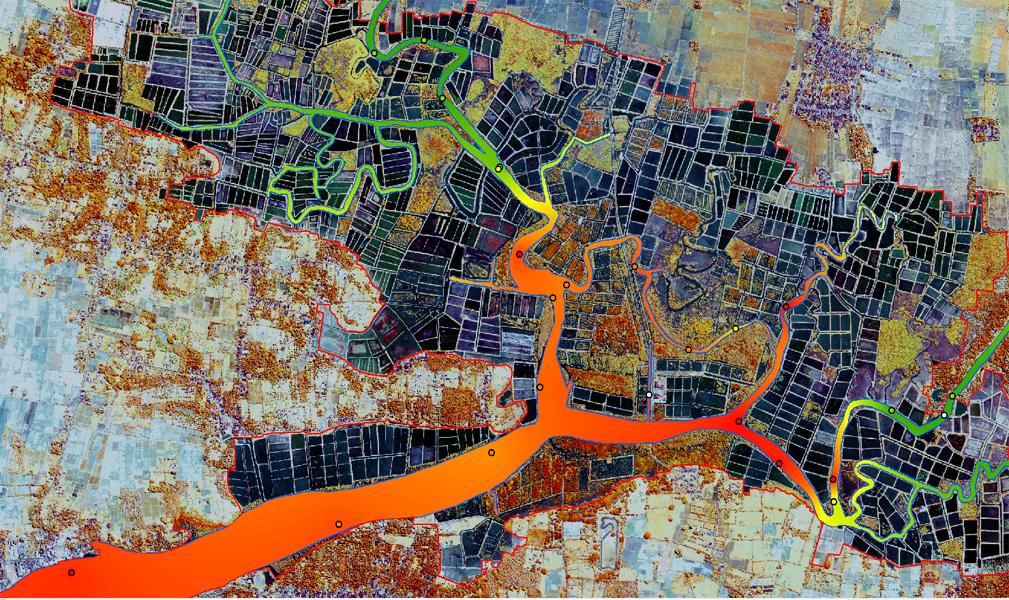
Salinity measurements recorded on May 14, 2014 and raster interpolation values - Perancak Site (Bali, Indonesia) - INDESO project
Location of sampling points and results of salinity measurements collected in the field by H. Lemonnier and N. Gusmawati at Perancak (Bali) May 14, 2014
These are ad hoc measures carried out in the main river by boat.
The data were then interpolated with Arcgis spatial analyst toolbox - TopoToRaster tool (ESRI)
Simple
- Title
-
Salinity measurements recorded on May 14, 2014 and raster interpolation values - Perancak Site (Bali, Indonesia) - INDESO project
- Date (Creation)
- 2014-09-02
- Citation identifier
- IFR_NEW_CAL_INDESO_SALIN_14May2014
- Abstract
-
Location of sampling points and results of salinity measurements collected in the field by H. Lemonnier and N. Gusmawati at Perancak (Bali) May 14, 2014
These are ad hoc measures carried out in the main river by boat.
The data were then interpolated with Arcgis spatial analyst toolbox - TopoToRaster tool (ESRI)
- Credit
-
Ifremer - H. Lemonnier et N. Gusmawati for sampling and measurements
- Credit
-
CLS to finance the mission
- Credit
-
IRD UMR AMAP - C. Proisy for the organization of the field mission
- Status
- Completed
- Point of contact
-
Organisation name Individual name Electronic mail address Role IFREMER
Lemonnier Hugues
Local service desk
- Maintenance and update frequency
- Not planned
-
Thèmes Sextant
-
-
/Physical Environment/Hydrodynamics/Water Column
-
-
GEMET - INSPIRE themes, version 1.0
-
-
Oceanographic geographical features
-
- Place
-
-
Perancak
-
- Access constraints
- Restricted
- Use constraints
- Other restrictions
- Other legal constraints
-
Restricted use for INDESO project
- Spatial representation type
- Vector
- Denominator
- 10000
- Language
- Français
- Character set
- UTF8
- Topic category
-
- Environment
- Begin date
- 2014-05-14T08:00:00
- End date
- 2014-05-14T13:00:00
))
- Reference system identifier
- EPSG / WGS 84 (EPSG:4326) / 7.9
- Topology level
- Geometry only
- Geometric object type
- Point
- Geometric object count
- 24
- Distribution format
-
Name Version ESRI Shapefile
10
- Distributor contact
-
Organisation name Individual name Electronic mail address Role Ifremer - Sextant
Production Unit
- Hierarchy level
- Dataset
Conformance result
- Title
-
Inspire specifications
- Date (Creation)
- 2014-09-02
- Explanation
-
Non évalué
- Pass
- Statement
-
Data derived from the analysis of seawater samples obtained at the field sites.
Metadata
- File identifier
- 3420c0a2-bf92-40bc-ae8a-27d0e7256bf5
- Metadata language
- Français
- Other language
-
Language Character encoding English
- Character set
- UTF8
- Parent identifier
-
Mission de Hugues Lemonnier et Niken Gusmawati sur le site de Perancak (Bali, Indonésie) dans le cadre du projet INDESO.
7d9a3013-a443-4491-b36b-10e4ef4d38d8
- Hierarchy level
- Series
- Date stamp
- 2020-06-04T00:31:47
- Metadata standard name
-
ISO 19115:2003/19139 - SEXTANT
- Metadata standard version
-
1.0
- Metadata author
-
Organisation name Individual name Electronic mail address Role Ifremer
Local service desk
accessData
Overviews
)))