Bathymetry - Saint-Paul and Amsterdam Islands (Data compilation, 2023)
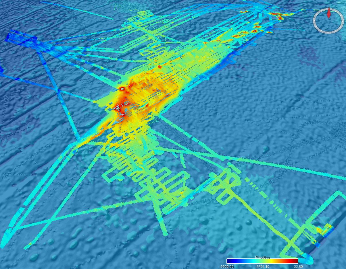
Bathymetry around Saint-Paul and Amsterdam Islands, with a grid resolution of 1/16 arcminute (3.75 arcseconde), updated in 2023. The Digital Terrain Model is the result of data compilation of several multibeam surveys.
The DTM was processed as part of the French national program (EXTRAPLAC) for the delineation of the outer limit of the continental shelf beyond 200 nautical miles, and in collaboration between Ifremer and the Western Brittany University (UBO Brest). The DTM is updated according to new bathymetric data acquired in this area.
Surveys reference :
- MD157/ PLURIEL: 2006, R/V Marion Dufresne, https://doi.org/10.17600/6200130
- BOOMRANG-Leg6: 1996, R/V Melville, https://calisphere.org/item/ark:/20775/bb9424302r/
The datasets from the following cruises have been also integrated:
- MD240/ OHA-SIS-BIO - OBSAUSTRAL: 2023, R/V Marion Dufresne, https://doi.org/10.17600/18002425
- MD238/ OHA-SIS-BIO : 2022, R/V Marion Dufresne, https://doi.org/10.17600/18002903
- MD171/ GEISEIR1: 2009, R/V Marion Dufresne, https://doi.org/10.17600/9200050
- MD120/ ANTAUS: 2000, R/V Marion Dufresne, https://doi.org/10.17600/200090
- MD118/ DEFLO: 2000, R/V Marion Dufresne, https://doi.org/10.17600/200070
- MD106/ IPHIS: 1997, R/V Marion Dufresne,https://doi.org/10.17600/97200010
- HYDROAMSTERDAM: 1984, R/V Jean Charcot, https://doi.org/10.17600/84000111
- MD197/ MYCTO: 2014, R/V Marion Dufresne, https://doi.org/10.17600/14002500
- MD211/ OBSAUSTRAL: 2018, R/V Marion Dufresne, https://doi.org/10.17600/18000490
- MD217/ OBSAUSTRAL: 2019, R/V Marion Dufresne,https://doi.org/10.17600/18000885
- VT51/ OISO6 : 2001, R/V Marion Dufresne, https://doi.org/10.17600/1200010
- MD106, MD174, MD175/GEISEIR-2, MD189/INDIEN SUD 2, MD201/OBSAUSTRAL, MD224/OBSAUSTRAL-1
- TN362 (Coring to Reconstruct Ocean Circulation and Carbon-dioxide Across 2 Seas: CROCCA-2s), R/V Thomas G. Thompson, 2018. 10.7284/908704
- NBP0406: 2004, R/V Nathaniel B. Palmer, DOI 10.7284/905502
Simple
- Title
-
Bathymetry - Saint-Paul and Amsterdam Islands (Data compilation, 2023)
- Date (Creation)
- 2019-08-19
- Date (Revision)
- 2023-11-24
- Citation identifier
- FR-330715-368-00032-Synthese_StPaulAmsterdam_1_16_BATHY
- Citation identifier
- DOI:10.12770/342b2892-b0de-4566-bd77-520fb3bf4eaa
- Cited responsible party
-
Organisation name Individual name Electronic mail address Role Ifremer
Géosciences Marines
Local service desk
- Presentation form
- Digital model
- Abstract
-
Bathymetry around Saint-Paul and Amsterdam Islands, with a grid resolution of 1/16 arcminute (3.75 arcseconde), updated in 2023. The Digital Terrain Model is the result of data compilation of several multibeam surveys.
The DTM was processed as part of the French national program (EXTRAPLAC) for the delineation of the outer limit of the continental shelf beyond 200 nautical miles, and in collaboration between Ifremer and the Western Brittany University (UBO Brest). The DTM is updated according to new bathymetric data acquired in this area.
Surveys reference :
- MD157/ PLURIEL: 2006, R/V Marion Dufresne, https://doi.org/10.17600/6200130
- BOOMRANG-Leg6: 1996, R/V Melville, https://calisphere.org/item/ark:/20775/bb9424302r/
The datasets from the following cruises have been also integrated:
- MD240/ OHA-SIS-BIO - OBSAUSTRAL: 2023, R/V Marion Dufresne, https://doi.org/10.17600/18002425
- MD238/ OHA-SIS-BIO : 2022, R/V Marion Dufresne, https://doi.org/10.17600/18002903
- MD171/ GEISEIR1: 2009, R/V Marion Dufresne, https://doi.org/10.17600/9200050
- MD120/ ANTAUS: 2000, R/V Marion Dufresne, https://doi.org/10.17600/200090
- MD118/ DEFLO: 2000, R/V Marion Dufresne, https://doi.org/10.17600/200070
- MD106/ IPHIS: 1997, R/V Marion Dufresne,https://doi.org/10.17600/97200010
- HYDROAMSTERDAM: 1984, R/V Jean Charcot, https://doi.org/10.17600/84000111
- MD197/ MYCTO: 2014, R/V Marion Dufresne, https://doi.org/10.17600/14002500
- MD211/ OBSAUSTRAL: 2018, R/V Marion Dufresne, https://doi.org/10.17600/18000490
- MD217/ OBSAUSTRAL: 2019, R/V Marion Dufresne,https://doi.org/10.17600/18000885
- VT51/ OISO6 : 2001, R/V Marion Dufresne, https://doi.org/10.17600/1200010
- MD106, MD174, MD175/GEISEIR-2, MD189/INDIEN SUD 2, MD201/OBSAUSTRAL, MD224/OBSAUSTRAL-1
- TN362 (Coring to Reconstruct Ocean Circulation and Carbon-dioxide Across 2 Seas: CROCCA-2s), R/V Thomas G. Thompson, 2018. 10.7284/908704
- NBP0406: 2004, R/V Nathaniel B. Palmer, DOI 10.7284/905502
- Credit
-
Ifremer
- Point of contact
-
Organisation name Individual name Electronic mail address Role Ifremer
Ifremer Marine Geosciences
Author Ifremer
LOUBRIEU Benoît
Author CNRS / UBO
ROYER Jean-Yves
Author CNRS / UBO
MAIA Marcia
Author Ifremer
Ifremer
Publisher
- Maintenance and update frequency
- As needed
- Discipline
-
-
Bathymetry
-
- Place
-
-
St-Paul
-
Amsterdam
-
-
GEMET - INSPIRE themes, version 1.0
-
-
Elevation
-
-
GEMET
-
-
Seabed mapping
-
Geo-morphology
-
-
Thèmes Sextant
-
-
/Physical Environment/Bathymetry/Digital Terrain Model
-
-
Thématiques - SIMM
-
-
/Environmental Status/Bathymetry
-
-
Sous-regions marines
-
-
/Overseas France/Indian Ocean
-
-
Thématiques - SIMM
-
-
Research
-
- Access constraints
- Other restrictions
- Use constraints
- License
- Other legal constraints
-
Open access
- Use limitation
-
Ne pas utiliser pour la navigation
- Spatial representation type
- Grid
- Distance
- 3.75 Arc second
- Denominator
- 200000
- Language
- Français
- Character set
- UTF8
- Topic category
-
- Elevation
- Environment description
-
Version 6.2 (Build 9200) ; Esri ArcGIS 10.7.1.11595
))
- Begin date
- 1984-02-24
- End date
- 2023-03-01
- Reference system identifier
- EPSG / WGS 84 (EPSG:4326) / 7.4
- Number of dimensions
- 2
- Dimension name
- Column
- Dimension size
- 14400
- Dimension name
- Row
- Dimension size
- 11680
- Cell geometry
- Area
- Transformation parameter availability
- Checkpoint Availability
Center point
- Point in Pixel
-
- Center
- Distribution format
-
Name Version Geotiff
- OnLine resource
-
Protocol Linkage Name WWW:LINK
https://www.extraplac.fr/ WWW:LINK-1.0-http--metadata-URL
https://doi.org/10.12770/342b2892-b0de-4566-bd77-520fb3bf4eaa DOI du jeu de donnée
- OnLine resource
-
Protocol Linkage Name OGC:WMS
https://sextant.ifremer.fr/services/wms/gm_bathy Synthese_StPaulAmsterdam_1_16_BATHY
COPYFILE
Synthese_StPaulAmsterdam_1_16_BATHY
- Hierarchy level
- Dataset
- Statement
-
The DTM is a result of collaboration between the Ifremer Marine Geosciences unit and the scientific group of the Pluriel cruise (Brest University).
Multibeam data were controlled and processed with Ifremer software (Caraïbes and Globe).
A similar processing chain is applied to each dataset:
- Selection of relevant profiles for acoustic coverage of the study area
- Automatic and manual filtering of outliers and erroneous data
- Control of overlapping zones
- Production of a digital terrain model. Depth layer is calculated as the average of soundings in each pixel.
All DTMs are merged into a unique DTM for the area. Grid resolution is 150 m.
- Attribute description
- Profondeur
- Content type
- Image
- Descriptor
-
Band_1
- Maximum value
- -43.799999
- Minimum value
- -5280.200195
- Bits per value
- 32
- Triangulation indicator
- Radiometric calibration data availability
- Camera calibration information availability
- Film distortion information availability
- Lens distortion information availability
Metadata
- File identifier
- 342b2892-b0de-4566-bd77-520fb3bf4eaa
- Metadata language
- Français
- Other language
-
Language Character encoding English
- Character set
- UTF8
- Hierarchy level
- Dataset
- Hierarchy level name
-
dataset
- Date stamp
- 2025-01-28T09:03:02.341112Z
- Metadata standard name
-
ISO 19115:2003/19139 - SEXTANT
- Metadata standard version
-
V. 1.2
- Metadata author
-
Organisation name Individual name Electronic mail address Role Ifremer
Géosciences Marines
Local service desk
)))