Inter annual hydrodynamic hindcast with MARS3D-AGRIF model - Bay of biscay and Manche Areas
"Abstract: "
Hydrodynamic database build with the MARS3D model along the french manche and atlantic coast at high spatial (500m) and temporal (1h) resolution
"Details:"
Seabed habitats maps are build from statistics models which need some data that describe the physical
environment of the different species. Theses environmental factors are the salinity, temperature and
shear stress (from waves and current) on the sea floor. Statistics are based on realistic and inter-annual
simulations from 3D ocean models.Models output are currently available at a uniform resolution of 2.5 km along the whole French coast,as a part of the PREVIMER project (http://www.previmer.org)
To increase the horizontal resolution of the model to 500m grid spacing, an on-line grid refinement
technique has been carried out with the AGRIF library. (http://www-ljk.imag.fr/MOISE/AGRIF/)
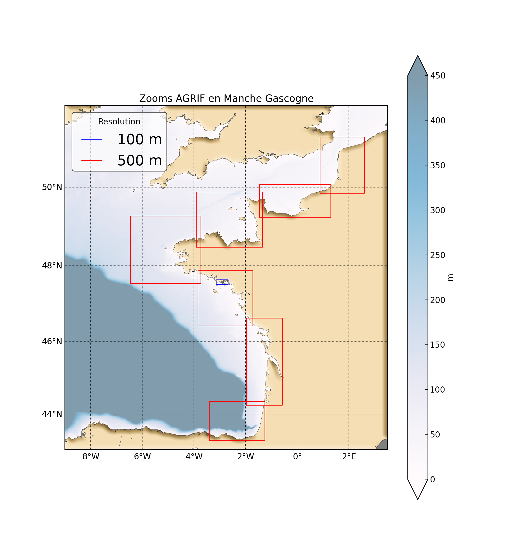
Seven zooms (with 500m resolution) have been implemented in the 2.5 km MANGAE configuration.
From this configuration, an hindcast of six years (from 2010 to 2015) has been simulated and cover the french coast from spain to pas-de-calais area :
"Main features of the hindcast"
Horizontal resolution : 500m
Vertical resolution : 40 sigma levels
Temporal resolution : 1 Hour
"Available physical parameters"
◦ 2D : Sea surface height and barotropic velocities (U and V components)
◦ 3D : Temperature, Salinity and baroclinic velocities
Simple
- Title
-
Inter annual hydrodynamic hindcast with MARS3D-AGRIF model - Bay of biscay and Manche Areas
- Date (Publication)
- 2016-09-21
- Citation identifier
- FR-330-715-368-00032-IFR_F_HYDRO_MARS3D_500M
- Citation identifier
- DOI:10.12770/3edee80f-5a3e-42f4-9427-9684073c87f5
- Abstract
-
"Abstract: "
Hydrodynamic database build with the MARS3D model along the french manche and atlantic coast at high spatial (500m) and temporal (1h) resolution
"Details:"
Seabed habitats maps are build from statistics models which need some data that describe the physical
environment of the different species. Theses environmental factors are the salinity, temperature and
shear stress (from waves and current) on the sea floor. Statistics are based on realistic and inter-annual
simulations from 3D ocean models.Models output are currently available at a uniform resolution of 2.5 km along the whole French coast,as a part of the PREVIMER project (http://www.previmer.org)
To increase the horizontal resolution of the model to 500m grid spacing, an on-line grid refinement
technique has been carried out with the AGRIF library. (http://www-ljk.imag.fr/MOISE/AGRIF/)
Seven zooms (with 500m resolution) have been implemented in the 2.5 km MANGAE configuration.
From this configuration, an hindcast of six years (from 2010 to 2015) has been simulated and cover the french coast from spain to pas-de-calais area :
"Main features of the hindcast"
Horizontal resolution : 500m
Vertical resolution : 40 sigma levels
Temporal resolution : 1 Hour
"Available physical parameters"
◦ 2D : Sea surface height and barotropic velocities (U and V components)
◦ 3D : Temperature, Salinity and baroclinic velocities
- Credit
-
IFREMER-DYNECO
- Point of contact
-
Organisation name Individual name Electronic mail address Role Ifremer
Caillaud Matthieu
Publisher Ifremer
Caillaud Matthieu
Author Ifremer
Petton Sebastien
Author Ifremer
Dumas Franck
Author Ifremer
Rochette Sebastien
Author Ifremer
Vasquez Mickael
Author
-
Thèmes Sextant
-
-
/Physical Environment/Coastal Hydrodynamics
-
-
GEMET - INSPIRE themes, version 1.0
-
-
Oceanographic geographical features
-
- Theme
-
-
hydrodynamic
-
modelling system
-
-
Sous-regions marines
-
-
/Metropolitan France/Bay of Biscay
-
/Metropolitan France/Channel-North Sea
-
/Metropolitan France/Celtic Seas
-
-
DCSMM : Descripteurs
-
-
D3: Commercially Exploited Species
-
D10: Marine Litter
-
D1: Coastal benthic habitats
-
D5: Eutrophication
-
D6: Sea-floor Integrity
-
D7: Hydrographical Conditions
-
-
Cadre Réglementaire - SIMM
-
-
Marine Strategy Framework Directive (MSFD)
-
Maritime Spatial Planning Directive (MSP)
-
-
Thématiques - SIMM
-
-
/Environmental Status/Hydrodynamics
-
- Use limitation
-
Data are available on a mail request
- Access constraints
- Other restrictions
- Use constraints
- Other restrictions
- Other legal constraints
-
Hindcast to quote in any publication
- Spatial representation type
- Grid
- Distance
- 500 meter
- Language
- Français
- Character set
- UTF8
- Topic category
-
- Oceans
))
- Begin date
- 2010-01-01
- End date
- 2015-12-31
- Reference system identifier
- EPSG / WGS 84 (EPSG:4326) / 8.6
- Distribution format
-
Name Version NetCDF
4
- OnLine resource
-
Protocol Linkage Name WWW:LINK
https://sextant.ifremer.fr/geonetwork/srv/api/records/3edee80f-5a3e-42f4-9427-9684073c87f5/attachments/hindcast_description.pdf Hindcast description
DOI
https://doi.org/10.12770/3edee80f-5a3e-42f4-9427-9684073c87f5 DOI of the dataset
- OnLine resource
-
Protocol Linkage Name WWW:DOWNLOAD
https://sextant.ifremer.fr/sextant_data/MANGAE2500-AGRIF/ MANGAE2500-AGRIF
- Hierarchy level
- Dataset
- Statement
-
This hindcast has been built with boundary conditions from MYOCEAN products, atmospheric forcing from the models of the French meteorological institute. A work of validation with various data (in situ, radar, satellite) from IFREMER's database has been carried out.
Process step
Metadata
- File identifier
- 3edee80f-5a3e-42f4-9427-9684073c87f5
- Metadata language
- Français
- Other language
-
Language Character encoding English
- Character set
- UTF8
- Hierarchy level
- Series
- Date stamp
- 2025-01-28T09:09:47.326033Z
- Metadata standard name
-
ISO 19115:2003/19139 - SEXTANT
- Metadata standard version
-
1.0
- Metadata author
-
Organisation name Individual name Electronic mail address Role Ifremer
Caillaud Matthieu
Local service desk
)))