Unequivocal VMEs and VME likelihood on the North Atlantic
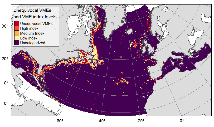
Distribution of unequivocal Vulnerable Marine Ecosystems (VMEs) and VME likelihood based on indicator taxa records, on the North Atlantic (18°N to 76°N and 36°E to 98°W). Several datasets, originating from public databases, literature review and data call to ATLAS partners, were gathered to compute the presence of unequivocal VME habitats in 25km * 25 km cells for the ATLAS work package 3. One layer displays the unequivocal VMEs (value=4) and the assigned high (value=3), medium (value=2) or low (value=1) likelihood of gridsquares to host VMEs, indexed on indicator taxa records from public databases with the method detailed in Morato et al (2018). The second displays the confidence associated to the VME likelihood score, indexed on data quality as detailed in Morato et al (2018) (values for unequivocal VMEs thus 100% confidence=4; high confidence=3; medium confidence=2; low confidence=1).
This dataset was built to feed a basin-wide spatial conservation planning exercise, targeting the deep sea of the North Atlantic. The goal of this approach was to identify conservation priority areas for Vulnerable Marine Ecosystems (VMEs) and deep fish species, based on the distribution of species and habitats, human activities and current spatial management.
Simple
- Title
-
Unequivocal VMEs and VME likelihood on the North Atlantic
- Date (Publication)
- 2019-08-14
- Citation identifier
- FR-330-715-368-00032-IFR_MARBEC_ATLAS_VME
- Citation identifier
- DOI:10.12770/3f14f4aa-ffaa-4152-865f-01be69048fce
- Abstract
-
Distribution of unequivocal Vulnerable Marine Ecosystems (VMEs) and VME likelihood based on indicator taxa records, on the North Atlantic (18°N to 76°N and 36°E to 98°W). Several datasets, originating from public databases, literature review and data call to ATLAS partners, were gathered to compute the presence of unequivocal VME habitats in 25km * 25 km cells for the ATLAS work package 3. One layer displays the unequivocal VMEs (value=4) and the assigned high (value=3), medium (value=2) or low (value=1) likelihood of gridsquares to host VMEs, indexed on indicator taxa records from public databases with the method detailed in Morato et al (2018). The second displays the confidence associated to the VME likelihood score, indexed on data quality as detailed in Morato et al (2018) (values for unequivocal VMEs thus 100% confidence=4; high confidence=3; medium confidence=2; low confidence=1).
This dataset was built to feed a basin-wide spatial conservation planning exercise, targeting the deep sea of the North Atlantic. The goal of this approach was to identify conservation priority areas for Vulnerable Marine Ecosystems (VMEs) and deep fish species, based on the distribution of species and habitats, human activities and current spatial management.
- Credit
-
Institut Français de Recherche pour l'Exploitation de la MER (France)
- Point of contact
-
Organisation name Individual name Electronic mail address Role IFREMER
Combes Magali
Author IFREMER
Vaz Sandrine
Author IFREMER
Publisher
-
Thèmes Sextant
-
-
/Biological Environment/Habitats
-
-
GEMET - INSPIRE themes, version 1.0
-
-
Habitats and biotopes
-
-
Mission Atlantic - Resources
-
-
Data
-
-
Mission Atlantic - Case Studies
-
-
North Mid-Atlantic Ridge
-
-
Mission Atlantic - Work Package
-
-
WP4 Benthic Mapping
-
-
Mission Atlantic - Data type (DMP)
-
-
Biological data
-
Spatial data products
-
-
Mission Atlantic - BODC Parameters
-
-
/Environment/Habitat
-
- Use limitation
- CC-BY-NC-SA (Creative Commons - Attribution, Pas d’utilisation commerciale, Partage dans les mêmes conditions)
- Access constraints
- License
- Use constraints
- License
- Spatial representation type
- Grid
- Distance
- 25 km
- Language
- English
- Character set
- UTF8
- Topic category
-
- Oceans
))
- Reference system identifier
- +proj=aea +lat_1=43 +lat_2=62 +lat_0=30 +lon_0=-30 +x_0=0 +y_0=0 +datum=WGS84 +units=m +no_defs +ellps=WGS84 +towgs84=0,0,0
- Number of dimensions
- 2
- Dimension name
- Row
- Dimension size
- 273
- Resolution
- 25 km
- Dimension name
- Column
- Dimension size
- 491
- Resolution
- 25 km
- Cell geometry
- Area
- Transformation parameter availability
- Distribution format
-
Name Version GeoTIFF
1.0
- OnLine resource
-
Protocol Linkage Name WWW:LINK
https://doi.org/10.3389/fmars.2018.00460 Morato et al. (2018) A Multi Criteria Assessment Method for Identifying Vulnerable Marine Ecosystems in the North-East Atlantic
WWW:LINK
https://sextant.ifremer.fr/geonetwork/srv/api/records/3f14f4aa-ffaa-4152-865f-01be69048fce/attachments/References%20used%20to%20list%20the%20cold%20seeps%20ecosystems.pdf References used to list the cold seeps ecosystems
WWW:LINK
http://vents-data.interridge.org Beaulieu, S. E., & Szafranski, K. (2018). InterRidge Global Database of Active Submarine Hydrothermal Vent Fields, Version 3.4. Retrieved from http://vents-data.interridge.org
WWW:LINK
https://vme.ices.dk ICES (2019) Vulnerable Marine Ecosystem (VME) indicators and habitats in the North Atlantic. https://vme.ices.dk
WWW:LINK
www.iobis.org OBIS (2019) Ocean Biogeographic Information System. Intergovernmental Oceanographic Commission of UNESCO. www.iobis.org
WWW:LINK
https://deepseacoraldata.noaa.gov/ NOAA (2019) Deep Sea Coral Data Portal. https://deepseacoraldata.noaa.gov/
- OnLine resource
-
Protocol Linkage Name WWW:LINK-1.0-http--metadata-URL
https://doi.org/10.12770/3f14f4aa-ffaa-4152-865f-01be69048fce DOI of the dataset
- Hierarchy level
- Dataset
Conformance result
- Title
-
RÈGLEMENT (UE) N o 1089/2010 DE LA COMMISSION du 23 novembre 2010 portant modalités d'application de la directive 2007/2/CE du Parlement européen et du Conseil en ce qui concerne l'interopérabilité des séries et des services de données géographiques
- Date (Publication)
- 2010-12-08
- Explanation
-
See the referenced specification
- Statement
-
Records of unequivocal (or bona fide) VMEs were collected from various public sources, the literature and ATLAS partners. Within ATLAS Deliverable 3.4, VME indicator species records were used to develop two indices on the North Atlantic, based on the multi criteria assessment method of Morato et al (2018): a taxa-dependent VME index displaying the likelihood of spatial cells to host VMEs; and an associated index of confidence based on source data quality. From this work, the presence of unequivocal VMEs and VME indices levels were extracted in 25km * 25 km gridsquares of the raster grid used for the ATLAS spatial prioritization.
Reference of the ATLAS deliverable: Magali Combes, Sandrine Vaz, Telmo Morato, Laurence Fauconnet, Sophie Arnaud-Haond, Carlos Dominguez-Carrió, Alan Fox, José-Manuel González-Irusta, Marina Carreiro-Silva, Andrew Davies, Pablo Durán Muñoz, Hrönn Egilsdóttir, Lea-Anne Henry, Ellen Kenchington, Camille Lirette, F. Javier Murillo-Perez, Covadonga Orejas, Berta Ramiro-Sánchez, Luís Rodrigues, Steve W. Ross, Dick van Oevelen, Christopher K. Pham, Carlos Pinto, Neil Golding, Jeff A. Ardron, Francis Neat, Xuan Bui, Oisin Callery, Anthony Grehan, Pascal Laffargue, Murray Roberts, David Stirling, Gerald Taranto, Mathieu Woillez, Lénaick Menot. (2019) ATLAS D3.4 Conservation Management Issues in ATLAS. Basin-scale systematic conservation planning: identifying suitable networks for VMEs protection. https://www.eu-atlas.org/resources/atlas-library
- Description
-
Unequivocal VMEs were defined as areas that have been explored, described and that meet the FAO criteria for defining Vulnerable Marine Ecosystems: uniqueness or rarity; functional significance of the habitat; fragility; life-history traits of component species that make recovery difficult; and structural complexity (FAO, 2009).
All known hydrothermal systems in the North Atlantic were extracted from the the InterRidge Global Database of Active Submarine Hydrothermal Vent Fields V3.4 (Beaulieu & Szafranski, 2018), independently of their status (active, inferred as active, inactive).
The literature was mined to list all known cold seep ecosystems in the North Atlantic (see list of references attached). One cold seep location explored through ATLAS, from the Gazul mud volcano in the Gulf of Cadiz (ATLAS Case Study 7), complemented the bibliographic survey. A total of 41 cold seeps and mud volcanoes were located in the study zone.
A major component of the ATLAS project has been the collection of new data on biodiversity and benthic communities through dedicated cruises. A data call was sent to ATLAS case studies leaders to summarize locations and descriptions of the unequivocal VMEs that have been identified within the ATLAS case studies and through ATLAS research activities (ATLAS Deliverable 3.4, 2019). Several of these VMEs have been discovered recently, and although those records have been described in publications or submitted to databases as ICES, they are not yet mentioned in public VME databases.
Public databases records of unequivocal VME habitats and of VME indicator taxa originated from the Ocean Biogeographic Information System portal (OBIS, 2019), the NOAA Deep Sea Coral Data Portal (NOAA, 2019), and the ICES Vulnerable Marine Ecosystems data portal (ICES, 2019). The dataset extracted from public databases is comprised of: 1) 'VME habitats' that are records for which there is unequivocal evidence for a VME and 2) 'VME indicators' which are records that suggest the presence of a VME with varying degrees of uncertainty.
References: Beaulieu, S. E., & Szafranski, K. (2018). InterRidge Global Database of Active Submarine Hydrothermal Vent Fields, Version 3.4. Retrieved from http://vents-data.interridge.org ; FAO (2009). Report of the Technical Consultation on International Guidelines for the Management of Deep-sea Fisheries in the High Seas, Rome. 4–8 February and 25–29 August 2008. Food and Agriculture Organization of the United Nations Fisheries and Aquaculture Report 881, 86 pp. ; ICES (2019) Vulnerable Marine Ecosystem (VME) indicators and habitats in the North Atlantic. https://vme.ices.dk ; OBIS (2019) Ocean Biogeographic Information System. Intergovernmental Oceanographic Commission of UNESCO. www.iobis.org. ; NOAA (2019) Deep Sea Coral Data Portal. https://deepseacoraldata.noaa.gov/
- Rationale
-
VMEs records collection
- Description
-
For VME indicators records, a multi-criterion assessment (MCA) method (Morato et al., 2018) was implemented on the 25km * 25km grid to assign ‘VME index’ and associated ‘Confidence index’ levels to gridsquares. The ‘VME index’ displays the likelihood of the cell to host VMEs depending on records of VME indicators. The scoring procedure, weighted for each type of VME indicator, combines how intrinsically vulnerable to human impacts the VME indicator is deemed to be, and how abundant the VME indicator is. The ‘Confidence index’ is a confidence (or uncertainty) estimate based upon availability and quality of the data found in each gridsquare. The values of the two indices were divided in categories of VME likelihood and confidence levels (low, medium and high) with the use of the Jenks natural breaks classification method.
Reference: Morato, T., Pham, C. K., Pinto, C., Golding, N., Ardron, J. A., Durán Muñoz, P., & Neat, F. (2018). A Multi Criteria Assessment Method for Identifying Vulnerable Marine Ecosystems in the North-East Atlantic. Frontiers in Marine Science, 5(460). https://doi.org/10/gftkv5
- Rationale
-
attribution of VME index from indicator species records
- Description
-
Using the R environment, the rasterize function was used to extract the presence of each type of unequivocal VMEs in 25km *25km gridsquares. Values of output raster cells where no unequivocal VMEs were present were set to 0, while values of cells out of the study zone were set to NA.
The VME habitats supersede the VME indicators. Thus, if a gridsquare had been attributed a VME index value but also an unequivocal VME, as determined by other datasets (hydrothermal vents, cold seeps, and ALTAS unequivocal VMEs), the index value was deleted, the gridsquare being already categorised as an 'unequivocal VME' habitat. Values of output raster cells where no VME index was attributed were set to 0, while values of cells out of the study zone were set to NA.
- Rationale
-
extraction of VME records on the ATLAS grid
Metadata
- File identifier
- 3f14f4aa-ffaa-4152-865f-01be69048fce
- Metadata language
- English
- Character set
- UTF8
- Hierarchy level
- Dataset
- Date stamp
- 2025-01-28T08:38:54.986372Z
- Metadata standard name
-
ISO 19115:2003/19139 - SEXTANT
- Metadata standard version
-
1.0
- Metadata author
-
Organisation name Individual name Electronic mail address Role IFREMER
Vaz Sandrine
Author IFREMER
Combes Magali
Author
)))