Benthic biocenoses of the Bay of La Ciotat
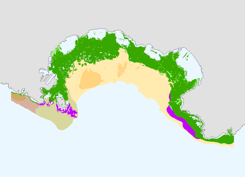
This mapping of the biocenosis in the sector of the Ciotat (Capuchin cove on the west edge of Défens east, to the bathymetric boundary of 35m) represents phase 1 of the study conducted by the General Council of Bouches-du-Rhône on the heritage in the surrounding areas of the departmental l'Ile Verte (Green Island) and Mugel.
All information collected on marine biotic communities of the Bay of La has helped to highlight the main evolutionary population trends in place, but also to identify gaps in terms of knowledge, including previous work in this sector.
This mapping is a synthesis of existing data associated with the processing of aerial photographs (BDORTHO IGN 1998), sonograms (campaign POSICART 2000) and recent video images.
It incorporates the data on the bay of St-Cyr-sur-Mer (Var) from a study of the Posidonia Herbarium: " Cartographie des biocénoses marines de la baie de Saint-Cyr-sur-Mer. Volet n°1 : l'Herbier à Posidonia océanica", February 2003, Agence de l'eau RM&C, Région PACA, DIREN PACA, Gis Posidonie, Ifremer, Centre d'Océanologie de Marseille.
The reference used of the coastline is unique to the study, probably from digitized aerial photographs and various campaigns in the sector.
Simple
- Title
-
Benthic biocenoses of the Bay of La Ciotat
- Alternate title
-
BIOMED_BIOC_CIOTAT_P
- Date (Publication)
- 2003-07-01T00:00:00
- Citation identifier
- BIOMED_BIOC_CIOTAT_P
- Presentation form
- Digital map
- Abstract
-
This mapping of the biocenosis in the sector of the Ciotat (Capuchin cove on the west edge of Défens east, to the bathymetric boundary of 35m) represents phase 1 of the study conducted by the General Council of Bouches-du-Rhône on the heritage in the surrounding areas of the departmental l'Ile Verte (Green Island) and Mugel.
All information collected on marine biotic communities of the Bay of La has helped to highlight the main evolutionary population trends in place, but also to identify gaps in terms of knowledge, including previous work in this sector.
This mapping is a synthesis of existing data associated with the processing of aerial photographs (BDORTHO IGN 1998), sonograms (campaign POSICART 2000) and recent video images.
It incorporates the data on the bay of St-Cyr-sur-Mer (Var) from a study of the Posidonia Herbarium: " Cartographie des biocénoses marines de la baie de Saint-Cyr-sur-Mer. Volet n°1 : l'Herbier à Posidonia océanica", February 2003, Agence de l'eau RM&C, Région PACA, DIREN PACA, Gis Posidonie, Ifremer, Centre d'Océanologie de Marseille.
The reference used of the coastline is unique to the study, probably from digitized aerial photographs and various campaigns in the sector.
- Purpose
-
L'objectif de la présente étude est de réaliser un état des lieux « année zéro » du patrimoine marin des domaines départementaux de l'île Verte et du Mugel, servant de référence à la mise en place et au suivi du plan de gestion de ces espaces naturels sensibles, acquis par le département en 1963 et 1982..
L'étude a été commanditée par le Département des Bouches du Rhône - Direction de l'environnement - Forêt / Bureau de l'eau, et a été menée par le GIS Posidonie, l'Ifremer (Laboratoire côtier DEL - Toulon) et Philippe Clabaut, consultant en Géologie Littorale et Marine.
- Credit
-
Medbenth
- Status
- On going
- Point of contact
-
Organisation name Individual name Electronic mail address Role Agence de l'Eau RM&C
Pierre BOISSERY
Local service desk Ifremer
Corinne TOMASINO
Local service desk Agence des aires marines protégées
Elodie Damier
Local service desk
- Maintenance and update frequency
- As needed
-
Thèmes Sextant
-
-
/Biological Environment/Habitats
-
- Place
-
-
Méditerranée
-
ciotat
-
- Keywords
-
-
biocenosis
-
habitat
-
posidonia
-
-
GEMET - INSPIRE themes, version 1.0
-
-
Habitats and biotopes
-
-
Cadre Réglementaire - SIMM
-
-
Directive Cadre pour la Planification de l'Espace Maritime (DCPEM)
-
Directive Cadre Stratégie pour le Milieu Marin (DCSMM)
-
-
Type de jeux de donnée ODATIS
-
-
/Processed data/Composite products
-
-
Thématiques - SIMM
-
-
/Etat du Milieu/Habitats
-
-
Sous-regions marines
-
-
Western Mediterranean
-
- Use limitation
-
This product has been developed in the context of achieving a synthesis of mapping work dealing with benthic biocenosis and available in the Mediterranean. This work was carried out in partnership by the l'Agence de l'eau Rhône Méditerranée & Corse (Water Agency Rhone Mediterranean & Corsica) and Ifremer. The files are for personal use. Any commercial use is strictly prohibited. For any purpose other than personal use please contact the custodian Mr. Bellouis.
- Access constraints
- Copyright
- Use constraints
- License
- Other legal constraints
-
Required citation : the General Council of Bouches du Rhône, IFREMER, GIS Posidonie, Philippe Clabaut Consultant.
- Other legal constraints
-
Required citation for the bibliography: " Etude du patrimoine marin environnant les domaines départementaux de l'île verte et du Mugel - phase 1 (Etat de la connaissance)," 2003, General Council of Bouches du Rhône, GIS Posidonie, Ifremer, Philippe Clabaut Consultant.
- Spatial representation type
- Vector
- Denominator
- 30000
- Language
- Français
- Character set
- UTF8
- Topic category
-
- Oceans
- Environment
))
- Supplemental Information
-
« Etude du patrimoine marin environnant les domaines départementaux de l'île Verte et du Mugel - phase 1 (Etat de la connaissance) », 2003, Conseil Général des Bouches-du-Rhône, GIS Posidonie, Ifremer, Philippe Clabaut Consultant.
- Reference system identifier
- 4326
- Topology level
- Geometry only
- Geometric object type
- Surface
Distributor
- Distributor contact
-
Organisation name Individual name Electronic mail address Role Ifremer
Dissemination Unit
- Distributor format
-
Name Version
- OnLine resource
-
Protocol Linkage Name OGC:WMS
https://sextant.ifremer.fr/services/wms/biologie? BIOMED_BIOC_CIOTAT_P
- OnLine resource
-
Protocol Linkage Name WWW:LINK
http://dx.doi.org/10.17600/450120 Campagne à la mer : POSICART 1
- Hierarchy level
- Dataset
- Statement
-
« Etude du patrimoine marin environnant les domaines départementaux de l'île verte et du Mugel - phase 1 (Etat de la connaissance) », 2003, Conseil général des Bouches du Rhône, GIS Posidonie, Ifremer, Philippe Clabaut Consultant.
Metadata
- File identifier
- 4280fd70-57c0-11dd-a60f-000086f6a603
- Metadata language
- Français
- Other language
-
Language Character encoding English
- Character set
- UTF8
- Hierarchy level
- Dataset
- Date stamp
- 2020-06-04T00:47:55
- Metadata standard name
-
ISO 19115:2003/19139 - SEXTANT
- Metadata standard version
-
1.0
- Metadata author
-
Organisation name Individual name Electronic mail address Role Ifremer
Local service desk
accessData
Overviews
)))