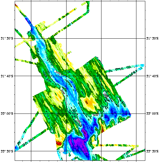
Central indian ridge between 21°S and 22°25’S - 120m
Reconnaissance geophysique, geologique, petrographique et geochimique systematique du point triple de Rodriguez ou convergent trois dorsales medio-oceanique. Exploration geophysique, geologique, petrographiqueet geochimique d'un segment de la zone axiale de chacune des trois dorsales. Reconnaissance, dans le bassin de Wharton, d'une dorsale fossile.
Simple
- Title
-
Central indian ridge between 21°S and 22°25’S - 120m
- Date (Creation)
- 1998-11-23
- Citation identifier
- IFR_MBAN_DORSALES_INDIEN_CIR22_BATHY_120_R
- Citation identifier
- DOI:10.12770/4b16433a-a60a-459d-aa90-bf3b788dab8c
- Abstract
-
Reconnaissance geophysique, geologique, petrographique et geochimique systematique du point triple de Rodriguez ou convergent trois dorsales medio-oceanique. Exploration geophysique, geologique, petrographiqueet geochimique d'un segment de la zone axiale de chacune des trois dorsales. Reconnaissance, dans le bassin de Wharton, d'une dorsale fossile.
- Credit
-
The project is part of the national program Dorsales and represents the French contribution to the InterRidge Data Banks project (see InterRidge News 1997, vol. 6/1 and 1999, vol. 8/1).
- Point of contact
-
Organisation name Individual name Electronic mail address Role Ifremer
Publisher UMR 7516 CNRS / Univ. Louis Pasteur
Daniel Sauter
Author
-
Thèmes Sextant
-
-
/Physical Environment/Bathymetry/Digital Terrain Model
-
-
GEMET - INSPIRE themes, version 1.0
-
-
Elevation
-
-
Type de jeux de donnée ODATIS
-
-
/Processed data/Composite products
-
-
Thématiques - SIMM
-
-
/Etat du Milieu/Géologie
-
/Etat du Milieu/Bathymétrie
-
-
Sous-regions marines
-
-
/Outre-mer/Océan Indien
-
-
Thématiques - SIMM
-
-
Recherche
-
- Use limitation
- CC-BY (Creative Commons - Attribution)
- Access constraints
- Other restrictions
- Use constraints
- License
- Other legal constraints
-
Sauter D., Whitechurch H., Nafziger J.M., & Munschy M., 1996 - Segmentation and morphotectonic variations of the Central Indian Ridge between 21˚10'S and 22˚25'S. J. Geophys Res., 101, p. 20233-20256
- Spatial representation type
- Grid
- Denominator
- 25000
- Language
- Français
- Character set
- UTF8
- Topic category
-
- Elevation
))
- Reference system identifier
- EPSG / WGS 84 (EPSG:4326) / 8.6
- Number of dimensions
- 2
- Dimension name
- Column
- Resolution
- 0.001166 degres
- Dimension name
- Row
- Resolution
- 0.001083 degres
- Cell geometry
- Area
- Distribution format
-
Name Version
- OnLine resource
-
Protocol Linkage Name OGC:WMS
https://sextant.ifremer.fr/services/wms/bathymetrie MOHNS_BATHY
FILE
MOHNS_BATHY
WWW:LINK-1.0-http--metadata-URL
https://doi.org/10.12770/4b16433a-a60a-459d-aa90-bf3b788dab8c DOI du jeu de données
- OnLine resource
-
Protocol Linkage Name COPYFILE
IFR_MBAN_DORSALES_INDIEN_CIR22_BATHY_120_R_GRD
- OnLine resource
-
Protocol Linkage Name WWW:LINK
http://dx.doi.org/10.17600/84001211 DOI de la campagne - RODRIGUEZ(2EME LEG)
- Hierarchy level
- Dataset
- Statement
-
Sources : Données de la campagne J. Charcot 1988, données Seabeam
- Description
-
0 spline en tension (surface)
- Rationale
-
Interpolation
Content Information
Metadata
- File identifier
- 4b16433a-a60a-459d-aa90-bf3b788dab8c
- Metadata language
- Français
- Other language
-
Language Character encoding English UTF8
- Character set
- UTF8
- Hierarchy level
- Dataset
- Date stamp
- 2020-08-31T11:24:09
- Metadata standard name
-
ISO 19115:2003/19139 - SEXTANT
- Metadata standard version
-
1.0
- Metadata author
-
Organisation name Individual name Electronic mail address Role UMR 7516 CNRS / Univ. Louis Pasteur
Daniel Sauter
Local service desk
accessData
Overviews
)))