Litto3D®
The Litto3D® project, along with the IGN, is responsible for producing detailed topographical and bathymetric information in mainland France so as to meet the needs of coastal and land-based stakeholders.
Simple
- Title
-
Litto3D®
- Date (Creation)
- 2005-01-01T00:00:00
- Citation identifier
- FR-DCSMM-PDS-BD_LITTO3D
- Presentation form
- Digital profile
- Abstract
-
The Litto3D® project, along with the IGN, is responsible for producing detailed topographical and bathymetric information in mainland France so as to meet the needs of coastal and land-based stakeholders.
- Purpose
-
The aim of the national Litto3D® programme is to produce a benchmark digital altimetric model to be used both on land and at sea along the coastal fringe. This involves conducting studies of the terrain of the sea floor and measuring marine depths in order to have accurate knowledge about all French mainland and overseas (Guadeloupe, Martinique, Reunion Island, French Guyana, Mayotte and Saint-Pierre-and-Miquelon) maritime areas.
The coastal fringe includes:
- At sea : up to the bathymetric contour at a continuous depth of 10m and at a maximum of 6 nautical miles from the coast.
- On land: up to an altitude of +10m, and at least 2 km inland.
In total, the scope of the programme covers around 45000 km².
- Credit
-
Data producers : IGN, SHOM
- Status
- On going
- Point of contact
-
Organisation name Individual name Electronic mail address Role SHOM
LAMARRE Vincent
Local service desk IGN
DUPERET Alain
Local service desk
- Maintenance and update frequency
- Not planned
- Maintenance note
-
Network Duration : perennial Network
- Theme
-
-
Topo-bathymetric product
-
Bathymetry
-
Topography
-
Altimetry
-
Coast
-
Terrain
-
Depth
-
Land
-
Sea
-
Seamless
-
Land-sea continuity
-
Digital model
-
Scatter diagram
-
Airborne Lidar
-
Airborne Laser
-
Multibeam surveying
-
-
GEMET - INSPIRE themes, version 1.0
-
-
Environmental monitoring facilities
-
-
Sous-regions marines
-
-
National
-
-
DCSMM : Type d'espace concerné
-
-
Pas d'espace particulier concerné
-
-
DCSMM : Descripteurs
-
-
D7: Hydrographical Conditions
-
-
DCSMM : Méthodes de recueil des données
-
-
Télédétection
-
-
Thèmes Sextant
-
-
/Physical Environment/Bathymetry/Digital Terrain Model
-
- Access constraints
- License
- Other legal constraints
-
Free access
The Litto3D® repository, integrating land part and sea part is released under license OpenData "Open License" (1.0 October 2011), defined by the Etalab mission.
- Use limitation
-
The Litto3D® product is subject to restrictions on certain controlled areas. As such, no data will be provided in these areas.
- Spatial representation type
- Vector
- Denominator
- 50000
- Language
- Français
- Character set
- UTF8
- Topic category
-
- Oceans
))
- Supplemental Information
-
Project leader :
Etat 2005
IGN 2005
SHOM 2005
Communauté d’agglomérations TPM 2007
EPA – EPIC partenaires 2009
Collectivités territoriales (Régions, Départements) 2009
Prime contractor :
SHOM / IGN 2005
Backers :
Etat 2005
IGN 2005
SHOM 2005
Communauté d’agglomérations 2007
EPA – EPIC partenaires 2009
Collectivités territoriales (Régions, Départements) 2009
Europe (FEDER) 2010
- Reference system identifier
- EPSG / WGS 84 (EPSG:4326) / 7.9
- Topology level
- Geometry only
- Geometric object type
- Complex
- Geometric object count
- 0
- OnLine resource
-
Protocol Linkage Name WWW:LINK
http://www.shom.fr/fileadmin/data/DOPS/MIP/PEP/BATHY/Litto3D/Doc_technique/Specifications-techniques-Litto3D_v1.4.pdf Spécifications techniques
- Hierarchy level
- Dataset
Conformance result
- Title
-
Inspire specifications
- Date (Creation)
- 2012-01-16
- Explanation
-
Non assessed
- Pass
- Statement
-
2005 : 1st Litto3D SHOM demonstration in the Golfe du Morbihan
2007 : 1st Litto3D IGN-SHOM demonstration in Toulon-Provence- Méditerranée (TPM)
2009 – 2012 : Start of production (Indian Ocean and Mainland France)
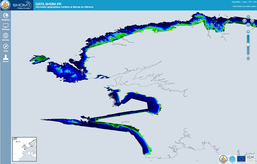
The Litto3D® database extends along the coastal fringe in the areas concerned according to the following criteria:
- at sea up to the bathymetric contour at a continuous depth of 10m (the “CB10 line”) including only the SHOM’s area for hydrographical responsibility. Any “holes” (areas which are not included in the specifications, but which are completely surrounded by the area to be covered) could also be included in coverage areas. The scope of the project could be extended out to sea, up to 6 nautical miles from the TdCH coastal limit, in order to include certain areas of particular interest, according to environmental conditions.
- On land, up to a continuous altitude contour of 10m (the “CN10” line in Figure 1), and at least 2km inland from the TdCH coastal limit (known as the (“TdCH + 2 km” line), within the limits of French territories including a buffer zone of 500m beyond French borders. Any “holes” could also be included in coverage areas.
The areas currently available are as follows:
- Golfe du Morbihan
- PACA region, partially (area from Cassis to the west of the Presqu’île de Giens, including TPM)
- Réunion
- Mayotte
- Iles Eparses
- Martinique
-
Areas currently being processed :
- Languedoc-Roussillon
- Finistère
- Guadeloupe
- PACA region
Surface surveying in order to obtain a comprehensive description of the coastal area with a point density of 1 point/m² or more for emerged areas, and 1 point/25m² at sea.
Litto3D® metadata is in XML format in accordance with encoding requirements determined by ISO 19139
Precision ( 95%) of the scatter cloud:
- Bathymetric data:
• Planimetric accuracy: 2.8 m
• Altimetric accuracy: 0.50 m
- Topographical data:
• Planimetric accuracy: 0.5 m
• Altimetric accuracy: 0.20 m
Survey measurement methods are as follows: aerial topographical laser for the land elements, aerial bathymetric laser for the maritime elements, and multibeam echosounder on board vessels to complete the maritime elements in areas which are inaccessible for the bathymetric laser (waters too deep or too rough).
Data is available in two formats: a three-dimensional scatter diagram and a meshed and validated digital terrain model.
- Description
-
Litto3D® reference material is only available in the legal planar projection of the area concerned, in association with the area’s legal geodesic system. The table below lists the legal geodesic systems and their associated planar projections.
- Description
-
Data type :
Relief
Physical oceanography
Hydrography
Precision on the data type :
3D Representation – bathymetric topography of the French coast.
Measured or observed parameters :
Altitude
Depths of the sea floor
Parameters resolution :
On land: point density of 1m*1m or better (1 point / m²).
Accuracy (95%) : planimetry 0.5m ; altimetry 0.2m
At sea: point desity of 5m*5m or better (1 point / 25m²).
Accuracy (95%) : planimetry 2.8m ; altimetry 0.5m
Update frequency : Undefined : depends on partnerships
Observation frequency : Undefined : depends on partnerships
- Description
-
Sampling method : Spatial
- Description
-
device associated : Histolitt, PNH
Metadata
- File identifier
- 4c54ac5e-9b83-42ad-b10e-e0769d6a1cd3
- Metadata language
- Français
- Other language
-
Language Character encoding English
- Character set
- UTF8
- Hierarchy level
- Series
- Date stamp
- 2020-06-04T00:46:01
- Metadata standard name
-
ISO 19115:2003/19139 - SEXTANT
- Metadata standard version
-
1.0
- Metadata author
-
Organisation name Individual name Electronic mail address Role Sextant
Local service desk
accessData
Overviews
)))