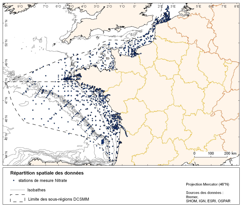
Spatial distribution of all data stations for various nutrients in the English Channel and Atlantic (silicate, nitrate, nitrite, ammonium and phosphate)
Spatial distribution for nutrients data (silicate, nitrate, nitrite, ammonium and phosphate) for all maritime regions in the English Channel and North Sea, the Celtic Seas and the Bay of Biscay.
The temporal extent of the data is from 1930 to 2010, most being between 1974 and 2007 with a peak in 1999.
Simple
- Title
-
Spatial distribution of all data stations for various nutrients in the English Channel and Atlantic (silicate, nitrate, nitrite, ammonium and phosphate)
- Alternate title
-
SLCA, NTRA, NTRI, AMMO,PHOS
- Date (Creation)
- 2011-06-01
- Date (Publication)
- 2011-06-01
- Citation identifier
- SLCA, NTRA, NTRI, AMMO, PHOS
- Abstract
-
Spatial distribution for nutrients data (silicate, nitrate, nitrite, ammonium and phosphate) for all maritime regions in the English Channel and North Sea, the Celtic Seas and the Bay of Biscay.
The temporal extent of the data is from 1930 to 2010, most being between 1974 and 2007 with a peak in 1999.
- Credit
-
Ifremer
- Point of contact
-
Organisation name Individual name Electronic mail address Role IFREMER
Sourisseau Marc
Local service desk
-
Thèmes Sextant
-
-
/Activités humaines/Activités scientifiques
-
- Theme
-
-
concentration
-
nutrients
-
monthly climatology
-
-
GEMET - INSPIRE themes, version 1.0
-
-
Oceanographic geographical features
-
- Place
-
-
English Channel
-
Bay of Biscay
-
- Access constraints
- Copyright
- Use constraints
- Copyright
- Classification
- Unclassified
- Spatial representation type
- Grid
- Distance
- 111120 metre
- Language
- Français
- Character set
- UTF8
- Topic category
-
- Geoscientific information
))
- Begin date
- 1930-01-01T16:08:00
- End date
- 2010-01-01T16:08:00
- Supplemental Information
-
All records derived from samples taken with Niskin bottles at various depths, and then analyzed in the laboratory. The parameters stored in the database and analyzed are :
− nitrate: NTRA (µmol/L)
− nitrite: NTRI (µmol/L)
− silicate: SLCA (µmol/L)
− ammonium: AMMO (µmol/L)
− phosphate: PHOS (µmol/L)
- Reference system identifier
- EPSG / WGS84 géographiques / 7.4
- Distribution format
-
Name Version fichiers de formes ESRI
ArcGIS 9.3.1
- OnLine resource
-
Protocol Linkage Name WWW:LINK
http://wwz.ifremer.fr/dcsmm site internet Ifremer dédié à la Directive Cadre Stratégie pour le Milieu Marin
WWW:LINK
http://www.ifremer.fr/sextant/fr/web/dcsmm/123_repartition_spatio-temporellle_nutriments carthothèque DCSMM
- Hierarchy level
- Dataset
- Statement
-
The data are from scientists personal databases (data not yet saved in the reference database, eg: the Modycot campaign) as well as data form national and international databases (ICES, SDN, QUADRIGE2) which represents the bulk of the data. There are, however, in these databases unverified or under moratorium (which are therefore
not used in the study).
Metadata
- File identifier
- 4d6d643d-e52e-4cf0-9840-ec2d3d7688df
- Metadata language
- Français
- Other language
-
Language Character encoding English
- Character set
- UTF8
- Hierarchy level
- Series
- Hierarchy level name
-
Ensemble de jeux de données
- Date stamp
- 2020-06-04T00:50:35
- Metadata standard name
-
ISO 19115:2003/19139 - SEXTANT
- Metadata standard version
-
1.0
- Metadata author
-
Organisation name Individual name Electronic mail address Role Ifremer Brest - Geosciences Marines
Etienne Laffay
Local service desk
accessData
Overviews
)))