Gas emissions from the Sea of Marmara seafloor from 4 November to 14 December 2009 (S. Dupré, 2015)
Spatial distribution of gaz emissions on Marmara Sea, established from acoustic water column data, acquired in 2009 during the MARMESONET marine expedition. The present dataset is a polygon shapefile. This seafloor surface represents the insonified area within which gas emissions occurred for more than 1 month of survey, from 4 November 2009 to 14 December 2009; as displayed in Figure 4 of the publication cited below "Tectonic and sedimentary controls for widespread gas emissions in the Sea of Marmara. Results from systematic, shipborne multibeam echosounder water column imageries." This publication investigated and discussed the relationship between fluid emissions at the seafloor with the fault network (active and inactive faults) and the sedimentary environment (nature, thickness and related-processes).
Oceanographic cruise at the source of the dataset :
- GELI Louis, HENRY Pierre, CAGATAY Namik (2009) MARMESONET cruise, RV Le Suroît, https://doi.org/10.17600/9020040
Bibliographic reference :
- Dupre Stephanie, Scalabrin Carla, Grall Celine, Augustin Jean-Marie, Henry Pierre, Sengor A. M. Celal, Goeruer Naci, Cagatay M. Namik, Geli Louis (2015). Tectonic and sedimentary controls on widespread gas emissions in the Sea of Marmara: Results from systematic, shipborne multibeam echo sounder water column imaging. Journal Of Geophysical Research-solid Earth, 120(5), 2891-2912. Publisher's official version : https://doi.org/10.1002/2014JB011617 , Open Access version : https://archimer.ifremer.fr/doc/00268/37972/
Simple
- Title
-
Gas emissions from the Sea of Marmara seafloor from 4 November to 14 December 2009 (S. Dupré, 2015)
- Date (Creation)
- 2018-04-26T04:00:00
- Date (Publication)
- 2018-04-26
- Citation identifier
- FR-330715-368-00032-GasEmission_Marmara_Dupre_2015
- Presentation form
- Digital map
- Abstract
-
Spatial distribution of gaz emissions on Marmara Sea, established from acoustic water column data, acquired in 2009 during the MARMESONET marine expedition. The present dataset is a polygon shapefile. This seafloor surface represents the insonified area within which gas emissions occurred for more than 1 month of survey, from 4 November 2009 to 14 December 2009; as displayed in Figure 4 of the publication cited below "Tectonic and sedimentary controls for widespread gas emissions in the Sea of Marmara. Results from systematic, shipborne multibeam echosounder water column imageries." This publication investigated and discussed the relationship between fluid emissions at the seafloor with the fault network (active and inactive faults) and the sedimentary environment (nature, thickness and related-processes).
Oceanographic cruise at the source of the dataset :
- GELI Louis, HENRY Pierre, CAGATAY Namik (2009) MARMESONET cruise, RV Le Suroît, https://doi.org/10.17600/9020040
Bibliographic reference :
- Dupre Stephanie, Scalabrin Carla, Grall Celine, Augustin Jean-Marie, Henry Pierre, Sengor A. M. Celal, Goeruer Naci, Cagatay M. Namik, Geli Louis (2015). Tectonic and sedimentary controls on widespread gas emissions in the Sea of Marmara: Results from systematic, shipborne multibeam echo sounder water column imaging. Journal Of Geophysical Research-solid Earth, 120(5), 2891-2912. Publisher's official version : https://doi.org/10.1002/2014JB011617 , Open Access version : https://archimer.ifremer.fr/doc/00268/37972/
- Credit
-
Ifremer
- Point of contact
-
Organisation name Individual name Electronic mail address Role Ifremer
Dupre Stephanie
Author Ifremer
Scalabrin Carla
Author Ifremer
Augustin Jean-Marie
Author Ifremer
Guerin Charline
Author Ifremer
Ogor André
Author Ifremer
Clouet Hélène
Author Ifremer
Geo-Ocean
Local service desk Ifremer
Publisher
- Discipline
-
-
Géophysics
-
- Place
-
-
Sea of Marmara
-
- Temporal
-
-
2009
-
- Theme
-
-
Gas emission
-
Water column acoustics
-
Multibeam echosounder
-
Gas bubbles
-
Marmesonet
-
- Keywords
-
-
Downloadable Data
-
-
GEMET - INSPIRE themes, version 1.0
-
-
Geology
-
-
Thèmes Sextant
-
-
/Physical Environment/Geology
-
- Use limitation
- CC-BY-NC-SA (Creative Commons - Attribution, No commercial usage, Sharing under the same conditions)
- Access constraints
- Other restrictions
- Use constraints
- License
- Other legal constraints
-
Pas de restriction d'accès public
- Spatial representation type
- Vector
- Language
- English
- Character set
- UTF8
- Topic category
-
- Geoscientific information
- Environment description
-
Microsoft Windows 7 Version 6.1 (Build 7601) Service Pack 1; Esri ArcGIS 10.3.0.4322
))
- Begin date
- 2009-11-04
- End date
- 2009-12-14
- Reference system identifier
- EPSG / WGS 84 (EPSG:4326) / 7.4
- Topology level
- Geometry only
- Geometric object type
- Surface
- Geometric object count
- 1
- Distributor contact
-
Organisation name Individual name Electronic mail address Role Ifremer
Local service desk
- OnLine resource
-
Protocol Linkage Name WWW:LINK
http://dx.doi.org/10.17600/9020040 MARMESONET Cruise
- OnLine resource
-
Protocol Linkage Name WWW:LINK-1.0-http--metadata-URL
http://doi.org/10.17882/54983 DOI of the dataset
WWW:LINK-1.0-http--publication-URL
http://doi.org/10.1002/2014JB011617 DOI of the main publication
- OnLine resource
-
Protocol Linkage Name OGC:WMS
https://sextant.ifremer.fr/services/wms/gm_geologie GAS_EMISSION_SPATIAL_DISTRIBUTION_MARMARA_2009
FILE
Gas_emission_spatial_distribution_SeaOfMarmara_4nov_14dec2009
- Hierarchy level
- Dataset
Conformance result
- Title
-
Inspire specifications
- Date (Creation)
- 2012-01-16
- Explanation
-
Non évalué
- Pass
- Statement
-
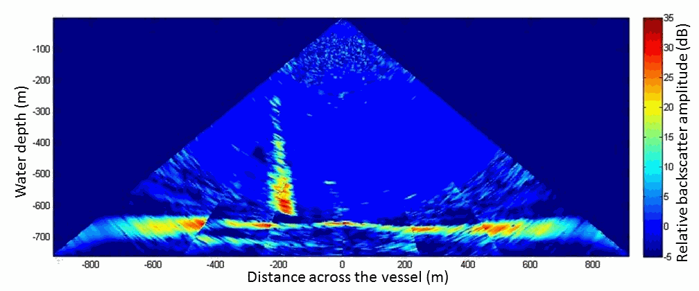
Acoustic detection of gas emissions was performed with water column imagery acquired in 2009 on board the R/V Le Suroît during the MARMESONET expedition, part of the ESONET (European Seas Observatory NETwork) Marmara demonstration mission (Marmara-DM) project. Water column data was acquired with a Kongsberg EM302 shipborne multibeam echo sounder. Water column multibeam acquisition is very efficient for the coverage of wide areas. Thus, more than 4500 km of acoustic tracks, equivalent to ~2900 km2, were recorded over 21 days of acquisition (4 November 2009 to 14 December 2009). Details on water column multibeam data acquisition, processing, vizualisation and identification of gas emissions from the seafloor are presented in the main publication.
Metadata
- File identifier
- 4ddb2884-3707-4bd0-9af4-6b9f540cea4b
- Metadata language
- Français
- Other language
-
Language Character encoding English UTF8
- Character set
- UTF8
- Hierarchy level
- Dataset
- Date stamp
- 2024-05-21T08:46:10.535Z
- Metadata standard name
-
ISO 19115:2003/19139 - SEXTANT
- Metadata standard version
-
1.0
- Metadata author
-
Organisation name Individual name Electronic mail address Role Ifremer
Geo-Ocean
Local service desk
)))