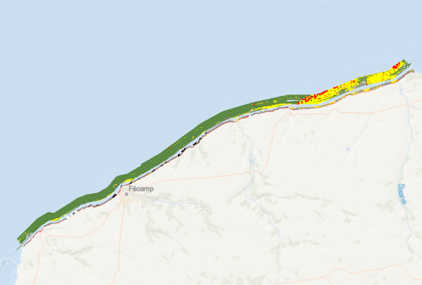
Formations superficielles du cap d'Antifer au cap d'Ailly (P.Clabaut, 2013)
Ce jeu de données vectorielles correspond à la "Carte des formations superficielles du cap d'Antifer au cap d'Ailly". Edition 2013. Echelle 1/20 000.
Campagne océanographique à l'origine de cette carte :
SATRA LE BRIS Catherine (2006) PLA-HANO cruise, RV Thalia, https://doi.org/10.17600/6070320
Référence bibliographique :
Augris Claude, Clabaut Philippe (2013). Cartographie morpho-sédimentaire des petits fonds marins du cap d'Antifer au cap d'Ailly. Partenariat Ifremer - Réseau d'observation du littoral normand et picard. Éd. Quae. 6 cartes, échelle 1/20 000, livret d’accompagnement, 80 pages.
Simple
- Title
-
Formations superficielles du cap d'Antifer au cap d'Ailly (P.Clabaut, 2013)
- Date (Publication)
- 2013-01-01T00:00:00
- Date (Creation)
- 2014-09-24T00:00:00
- Edition
-
carte papier, édition Ifremer
- Edition date
- 2013-01-01T00:00:00
- Citation identifier
- FR-330-715-368-00032-FormationsSup_CapAntiferCapAilly_Clabaut_2013_Facies
- Citation identifier
- DOI:10.12770/5131b504-1ce4-4c0d-8630-86163e4b714b
- Presentation form
- Digital map
- ISBN
-
2-84433-139-4
- Abstract
-
Ce jeu de données vectorielles correspond à la "Carte des formations superficielles du cap d'Antifer au cap d'Ailly". Edition 2013. Echelle 1/20 000.
Campagne océanographique à l'origine de cette carte :
SATRA LE BRIS Catherine (2006) PLA-HANO cruise, RV Thalia, https://doi.org/10.17600/6070320
Référence bibliographique :
Augris Claude, Clabaut Philippe (2013). Cartographie morpho-sédimentaire des petits fonds marins du cap d'Antifer au cap d'Ailly. Partenariat Ifremer - Réseau d'observation du littoral normand et picard. Éd. Quae. 6 cartes, échelle 1/20 000, livret d’accompagnement, 80 pages.
- Credit
-
Ifremer / Réseau d'Observation du Littoral Normand et Picard
- Status
- Completed
- Point of contact
-
Organisation name Individual name Electronic mail address Role Ifremer
Geo-Ocean
Local service desk Ifremer
SIMPLET Laure
Local service desk Ifremer
AUGRIS Claude
Author Géologie littorale et marine
CLABAUT Philippe
Author Ifremer
GAUTIER Emeric
Author Ifremer
Publisher
- Maintenance and update frequency
- Not planned
-
Thèmes Sextant
-
-
/Milieu physique/Géologie/Nature des fonds
-
-
GEMET - INSPIRE themes, version 1.0
-
-
Géologie
-
-
external.theme.gemet
-
-
sédiment marin
-
fond marin
-
- Theme
-
-
nature des fonds
-
formations superficielles
-
- Place
-
-
Haute Normandie
-
cap d'Antifer
-
cap d'Ailly
-
- Discipline
-
-
géophysique
-
sédimentologie
-
géologie
-
- Keywords
-
-
Plahano
-
- Use limitation
- CC-BY (Creative Commons - Attribution)
- Access constraints
- Other restrictions
- Use constraints
- License
- Other legal constraints
-
Pas de restriction d'accès public
- Other legal constraints
-
Proposition de citation : Augris C., Clabaut P.(coord.), 2013. Cartographie morpho-sédimentaire des petits fonds marins du cap d'Antifer au cap d'AIlly, Haute-Normandie. Partenariat Ifremer - Réseau d'observation du littoral normand et picard. Éd. Quae. 6 cartes, échelle 1/20 000, livret d’accompagnement, 80 pages.
- Aggregate Datasetindentifier
- 66def080-44b9-11e0-b687-005056987263
- Association Type
- Cross reference
- Aggregate Datasetindentifier
- 180f4500-44b8-11e0-b687-005056987263
- Association Type
- Cross reference
- Spatial representation type
- Vector
- Denominator
- 20000
- Language
- Français
- Character set
- UTF8
- Topic category
-
- Geoscientific information
- Description
-
Période d'acquisition des données
- Begin date
- 2006-10-03T08:00:00
- End date
- 2006-10-12T18:00:00
))
- Reference system identifier
- EPSG / WGS 84 (EPSG:4326) / 7.4
- Topology level
- Geometry only
Distributor
- Distributor contact
-
Organisation name Individual name Electronic mail address Role Ifremer - Centre de Brest
Dissemination Unit
- Distributor format
-
Name Version ESRI Shapefile
1.0
- OnLine resource
-
Protocol Linkage Name WWW:LINK-1.0-http--metadata-URL
http://doi.org/10.12770/5131b504-1ce4-4c0d-8630-86163e4b714b DOI du jeu de donnée
WWW:LINK
http://dx.doi.org/10.17600/6070320
- OnLine resource
-
Protocol Linkage Name OGC:WMS
https://sextant.ifremer.fr/services/wms/gm_geologie FormationsSup_CapAntiferCapAilly_Clabaut_2013_Facies
FILE
FormationsSup_CapAntiferCapAilly_Clabaut_2013_Facies
- OnLine resource
-
Protocol Linkage Name OGC:WMS
https://sextant.ifremer.fr/services/wms/gm_geologie FormationsSup_CapAntiferCapAilly_Clabaut_2013_FigureLin
FILE
FormationsSup_CapAntiferCapAilly_Clabaut_2013_FigureLin
- OnLine resource
-
Protocol Linkage Name OGC:WMS
https://sextant.ifremer.fr/services/wms/gm_geologie FormationsSup_CapAntiferCapAilly_Clabaut_2013_FigureSurf
FILE
FormationsSup_CapAntiferCapAilly_Clabaut_2013_FigureSurf
- Hierarchy level
- Dataset
Conformance result
- Title
-
INSPIRE
- Date (Creation)
- 2014-09-24
- Explanation
-
Non évalué
- Pass
- Statement
-
La carte a été digitalisée dans Adobe Illustrator puis importée dans ArcView en format DXF ou elle a été convertie en fichier de formes, géoréférencée et éditée.
Metadata
- File identifier
- 5131b504-1ce4-4c0d-8630-86163e4b714b
- Metadata language
- Français
- Character set
- UTF8
- Hierarchy level
- Dataset
- Date stamp
- 2024-04-05T08:10:15.09Z
- Metadata standard name
-
ISO 19115:2003/19139 - SEXTANT
- Metadata standard version
-
1.0
- Metadata author
-
Organisation name Individual name Electronic mail address Role Ifremer
Geo-Ocean
Local service desk
accessData
Overviews
)))