Intermediate Assessment 2017 - Seabed Litter - Relative number of litter items per square km
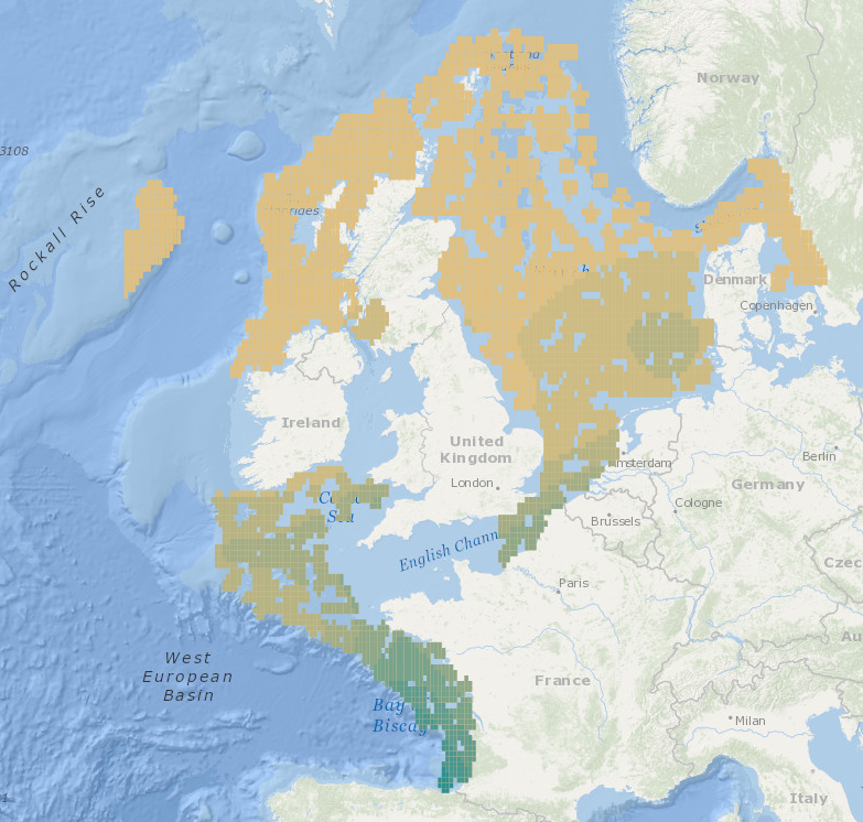
Intermediate Assessment 2017 - Seabed Litter - Litter is widespread on the seafloor across the area assessed, with plastic being the predominant material encountered. In the areas assessed, higher amounts of litter are found in the Eastern Bay of Biscay, Southern Celtic Seas and English Channel relative to the north of the Greater North Sea and Celtic Seas.
Simple
- Title
-
Intermediate Assessment 2017 - Seabed Litter - Relative number of litter items per square km
- Date (Publication)
- 2017-01-01
- Citation identifier
- 5785dea9-9404-498e-b12f-3de4402aa2e2
- Abstract
-
Intermediate Assessment 2017 - Seabed Litter - Litter is widespread on the seafloor across the area assessed, with plastic being the predominant material encountered. In the areas assessed, higher amounts of litter are found in the Eastern Bay of Biscay, Southern Celtic Seas and English Channel relative to the north of the Greater North Sea and Celtic Seas.
- Credit
-
OSPAR Commission
- Point of contact
-
Organisation name Individual name Electronic mail address Role OSPAR
Author OSPAR
Publisher
-
Thèmes Sextant
-
-
/Human Activities/Pollution
-
-
GEMET - INSPIRE themes, version 1.0
-
-
Environmental monitoring facilities
-
-
Mission Atlantic - Resources
-
-
Data
-
-
Mission Atlantic - Case Studies
-
-
Celtic Seas
-
-
Mission Atlantic - BODC Parameters
-
-
/Environment/Pollution
-
-
Mission Atlantic - ODEMM
-
-
/Pressures/Marine litter
-
-
Mission Atlantic - Data type (DMP)
-
-
Spatial data products
-
-
Mission Atlantic - Work Package
-
-
WP4 Benthic Mapping
-
- Use limitation
- CC0 (Creative Commons - Transfer into public domain)
- Spatial representation type
- Grid
- Language
- English
- Character set
- UTF8
- Topic category
-
- Oceans
))
- Distribution format
-
Name Version ESRI Shapefile
1.0
- OnLine resource
-
Protocol Linkage Name WWW:LINK
https://odims.ospar.org/en/maps/ia2017-seabed-litter_items-per-square-km_5gmh9/ IA2017 Seabed Litter - Relative number of litter items per square km
- Hierarchy level
- Dataset
Metadata
- File identifier
- 5785dea9-9404-498e-b12f-3de4402aa2e2
- Metadata language
- English
- Character set
- UTF8
- Hierarchy level
- Dataset
- Date stamp
- 2023-10-01T16:46:38.457Z
- Metadata standard name
-
ISO 19115:2003/19139 - SEXTANT
- Metadata standard version
-
1.0
- Metadata author
-
Organisation name Individual name Electronic mail address Role Ifremer
Sextant
Local service desk
accessData
Overviews
)))