Bathy-morphology of the Mediterranean (MediMap, edition 2008 resolution 1000 m and 500 m)
For this product, see the most recent data from the EMODnet Bathymetry project: https://emodnet.ec.europa.eu/en/bathymetry.
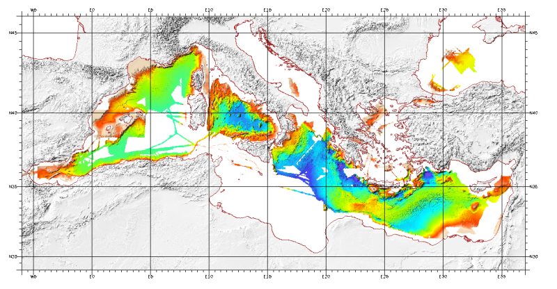
Bathymetric model (Digital Terrain Model) of the Mediterranean. MediMap group.
Bathymetry data acquired by multibeam sounders during campaigns Almofront.leg1 and Almofront.leg2, Almofront, Bretane, Seamewe2, Heralis, Medee, Anaxiprobe, Almofront2 - leg1 and leg2, Prismed2, Marmara, Fanil, Tvic5 et 6, Progres, Maradja, Blac, Nautinil, Medor-Simed1 / 2 / 3 / 4 / 5, Maradja2, Sardinia, Prisme, Assemblage and Thertou. Integration of partner organizations DTM.
This DTM is available at two cell sizes : 500 meters and 1000 meters.
Partners MediMap :
- SHOM (service Hydrographique et Océanographique de la Marine) ;
- CNRS/INSU (Centre National de la recherche Scientifique / Institut National des Sciences de l'Univers) ;
- Géosciences Azur / Observatoire Océanologique de Villefranche sur Mer ;
- ENS Paris (Ecole Nationale Supérieure de Paris) ;
- UBO/IUEM (Université de Bretagne Occidentale / Institut Universitaire Européen de la Mer)
- UP (Université de Perpignan / Laboratoire d'Etudes des Géo-environnements Marins) ;
- UB/GRC-GM (Universitat de Barcelona / Geociències Marines) ;
- IEO (Instituto Espanol de Oceanografia) ;
- IHM (Instituto Hidrografico de la Marina) ;
- Instituto Andaluz de Ciencias de la Tierra / Unitat de Tecnologia Marina, CMIMA / Universidad de Granada ;
- ISMAR (Istituto di Scienze Marine) ;
- Istituto Nazionale di Oceanografia e di Geofisica Sperimentale OGS/RIMA ;
- Università di Trieste / Università della Calabria - Scienze della Terra ;
- HCMR (Hellenic Centre for Marine Research) ;
- NWO (Nederlandse organisatie voor Wetenschappelijk Onderzoek / Vrije Universiteit Amsterdam ;
- Israel's national Bathymetric Survey.
Simple
- Title
-
Bathy-morphology of the Mediterranean (MediMap, edition 2008 resolution 1000 m and 500 m)
- Alternate title
-
Synthese_Mediterranee_Medimap_500m_BATHY
- Alternate title
-
Synthese_Mediterranee_Medimap_1000m_BATHY
- Date (Publication)
- 2008-01-01T00:00:00
- Date (Creation)
- 2008-01-01T00:00:00
- Edition
-
Ifremer - CIESM
- Edition date
- 2008-01-01T00:00:00
- Citation identifier
- FR-330-715-368-00032-Synthese_Mediterranee_Medimap_1000m_BATHY
- Citation identifier
- DOI:10.12770/5924fa10-ac45-11de-8853-000086f6a603
- Presentation form
- Digital map
- Abstract
-
For this product, see the most recent data from the EMODnet Bathymetry project: https://emodnet.ec.europa.eu/en/bathymetry.
Bathymetric model (Digital Terrain Model) of the Mediterranean. MediMap group.
Bathymetry data acquired by multibeam sounders during campaigns Almofront.leg1 and Almofront.leg2, Almofront, Bretane, Seamewe2, Heralis, Medee, Anaxiprobe, Almofront2 - leg1 and leg2, Prismed2, Marmara, Fanil, Tvic5 et 6, Progres, Maradja, Blac, Nautinil, Medor-Simed1 / 2 / 3 / 4 / 5, Maradja2, Sardinia, Prisme, Assemblage and Thertou. Integration of partner organizations DTM.
This DTM is available at two cell sizes : 500 meters and 1000 meters.
Partners MediMap :
- SHOM (service Hydrographique et Océanographique de la Marine) ;
- CNRS/INSU (Centre National de la recherche Scientifique / Institut National des Sciences de l'Univers) ;
- Géosciences Azur / Observatoire Océanologique de Villefranche sur Mer ;
- ENS Paris (Ecole Nationale Supérieure de Paris) ;
- UBO/IUEM (Université de Bretagne Occidentale / Institut Universitaire Européen de la Mer)
- UP (Université de Perpignan / Laboratoire d'Etudes des Géo-environnements Marins) ;
- UB/GRC-GM (Universitat de Barcelona / Geociències Marines) ;
- IEO (Instituto Espanol de Oceanografia) ;
- IHM (Instituto Hidrografico de la Marina) ;
- Instituto Andaluz de Ciencias de la Tierra / Unitat de Tecnologia Marina, CMIMA / Universidad de Granada ;
- ISMAR (Istituto di Scienze Marine) ;
- Istituto Nazionale di Oceanografia e di Geofisica Sperimentale OGS/RIMA ;
- Università di Trieste / Università della Calabria - Scienze della Terra ;
- HCMR (Hellenic Centre for Marine Research) ;
- NWO (Nederlandse organisatie voor Wetenschappelijk Onderzoek / Vrije Universiteit Amsterdam ;
- Israel's national Bathymetric Survey.
- Credit
-
Ifremer, CIESM, MediMap Group, 2008
- Status
- Obsolete
- Point of contact
-
Organisation name Individual name Electronic mail address Role MediMap Group
MediMap Group
Author Ifremer
LOUBRIEU Benoit
Author CNRS-Insu - Géosciences Azur
MASCLE Jean
Author CIESM / Ifremer
Publisher
- Maintenance and update frequency
- Not planned
-
external.theme.gemet
-
-
seabed
-
underwater morphology
-
- Theme
-
-
bathymetry
-
Digital Terrain Model
-
- Place
-
-
Mediterranean Sea
-
- Discipline
-
-
geophysics
-
- Use limitation
- CC-BY (Creative Commons - Attribution)
- Access constraints
- Other restrictions
- Use constraints
- License
- Other legal constraints
-
Required citation : MediMap Group, Loubrieu B., Mascle J. et al. (2008) Morpho-bathymetry of the Mediterranean Sea, CIESM / Ifremer special publication, Atlases and Maps, one map at 1/3 000 000.
- Other legal constraints
-
Proposition de citation : MediMap Group, Loubrieu B., Mascle J. et al. (2008) Morpho-bathymetry of the Mediterranean Sea, CIESM / Ifremer special publication, Atlases and Maps, one map at 1/3 000 000.
- Aggregate Datasetindentifier
- ff3aff8a-cff1-44a3-a2c8-1910bf109f85
- Association Type
- Cross reference
- Spatial representation type
- Grid
- Denominator
- 1000000
- Language
- Français
- Character set
- UTF8
- Topic category
-
- Elevation
- Description
-
period of data acquisition
- Begin date
- 1991-01-01T16:39:00
- End date
- 2007-12-31T15:00:00
))
- Reference system identifier
- EPSG / WGS 84 / World Mercator (EPSG:3395) Latitude d'échelle conservée 38°N / 7.4
- Number of dimensions
- 2
- Dimension name
- Row
- Dimension size
- 1890
- Resolution
- 1000 mètre,
- Dimension name
- Column
- Dimension size
- 3777
- Resolution
- 1000 mètre,
- Cell geometry
- Area
- Transformation parameter availability
Distributor
- Distributor contact
-
Organisation name Individual name Electronic mail address Role Ifremer - Centre de Brest
Dissemination Unit
- Distributor format
-
Name Version
- OnLine resource
- OnLine resource
-
Protocol Linkage Name DOI
https://doi.org/10.12770/5924fa10-ac45-11de-8853-000086f6a603 DOI of the dataset
- OnLine resource
-
Protocol Linkage Name OGC:WMS
https://sextant.ifremer.fr/services/wms/gm_bathy Synthese_Mediterranee_Medimap_1000m_BATHY
COPYFILE
Synthese_Mediterranee_Medimap_1000m_BATHY
- OnLine resource
-
Protocol Linkage Name OGC:WMS
https://sextant.ifremer.fr/services/wms/gm_bathy Synthese_Mediterranee_Medimap_500m_BATHY
COPYFILE
Synthese_Mediterranee_Medimap_500m_BATHY
- Hierarchy level
- Dataset
- Description
-
étendue verticale du MNT
Vertical extent
- Minimum value
- -5118
- Maximum value
- -5
Vertical CRS
Vertical CS
Vertical datum
Conformance result
- Title
-
INSPIRE
- Date (Publication)
- 2007-03-14
- Explanation
-
Non évalué
- Pass
- Statement
-
Données de bathymétrie acquises par les sondeurs multifaisceaux au cours des campagnes Almofront.leg1 et Almofront.leg2, Almofront, Bretane, Seamewe2, Heralis, Medee, Anaxiprobe, Almofront2 - leg1 et leg2, Prismed2, Marmara, Fanil, Tvic5 et 6, Progres, Maradja, Blac, Nautinil, Medor-Simed1 / 2 / 3 / 4 / 5, Maradja2, Sardinia, Prisme, Assemblage et Thertou.
- Description
-
Traitement des données avec le logiciel Caraïbes
- Description
-
Projection Mercator, latitude conservée 38N, méridien d'origine 0, ellipsoide WGS_84
Metadata
- File identifier
- 5924fa10-ac45-11de-8853-000086f6a603
- Metadata language
- Français
- Other language
-
Language Character encoding English
- Character set
- UTF8
- Hierarchy level
- Dataset
- Date stamp
- 2025-01-28T09:18:03.595943Z
- Metadata standard name
-
ISO 19115:2003/19139 - SEXTANT
- Metadata standard version
-
1.0
- Metadata author
-
Organisation name Individual name Electronic mail address Role Ifremer - Geo-Ocean
Local service desk
)))