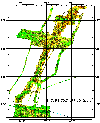
Mid-Atlantic Ridge between 23 and 31°N - 500m
Identification d'une manière géophysique (magnétisme, gravimétrie et bathymétrie), les segments de la dorsale Atlantique entre 23 et 31N, actuels et passés (jusqu'à 10 millions d'années), en précisant leur géométrie et leurs frontières.
Simple
- Title
-
Mid-Atlantic Ridge between 23 and 31°N - 500m
- Date (Creation)
- 1998-01-01
- Citation identifier
- IFR_MBAN_DORSALES_ATLAN_23_31_BATHY_500_R
- Citation identifier
- DOI:10.12770/5b168ab2-f315-424b-92e9-e356ba646f14
- Abstract
-
Identification d'une manière géophysique (magnétisme, gravimétrie et bathymétrie), les segments de la dorsale Atlantique entre 23 et 31N, actuels et passés (jusqu'à 10 millions d'années), en précisant leur géométrie et leurs frontières.
- Credit
-
The project is part of the national program Dorsales and represents the French contribution to the InterRidge Data Banks project (see InterRidge News 1997, vol. 6/1 and 1999, vol. 8/1).
- Point of contact
-
Organisation name Individual name Electronic mail address Role Ifremer
Publisher CNRS UMR 6538
Gente Pascal
Author CNRS UMR 6538
Thibaud Rémy
Author
-
Thèmes Sextant
-
-
/Physical Environment/Bathymetry/Digital Terrain Model
-
-
GEMET - INSPIRE themes, version 1.0
-
-
Elevation
-
-
Thématiques - SIMM
-
-
/Environmental Status/Bathymetry
-
/Environmental Status/Geology
-
-
Thématiques - SIMM
-
-
Research
-
- Use limitation
- CC-BY (Creative Commons - Attribution)
- Access constraints
- Other restrictions
- Use constraints
- License
- Other legal constraints
-
THIBAUD R., GENTE P. and MAIA M., 1998. A systematic analysis of the Mid-Atlantic Ridge morphology and gravity between 15°N and 40°N : constraints of the thermal structure. J. Geophys. Res., 103, 24223-24243
- Spatial representation type
- Grid
- Denominator
- 25000
- Language
- Français
- Character set
- UTF8
- Topic category
-
- Elevation
- Reference system identifier
- EPSG / WGS 84 (EPSG:4326) / 8.6
- Number of dimensions
- 2
- Dimension name
- Column
- Resolution
- 0.00449113 degres
- Dimension name
- Row
- Resolution
- 0.0045214 degres
- Cell geometry
- Area
- Distribution format
-
Name Version
- OnLine resource
-
Protocol Linkage Name OGC:WMS
https://sextant.ifremer.fr/services/wms/bathymetrie MOHNS_BATHY
FILE
MOHNS_BATHY
WWW:LINK-1.0-http--metadata-URL
https://doi.org/10.12770/5b168ab2-f315-424b-92e9-e356ba646f14 DOI du jeu de données
- OnLine resource
-
Protocol Linkage Name COPYFILE
IFR_MBAN_DORSALES_ATLAN_23_31_BATHY_500_R_GRD
- OnLine resource
-
Protocol Linkage Name WWW:LINK
http://dx.doi.org/10.17600/91004411 DOI de la campagne - FARA - SEADMA I
- Hierarchy level
- Dataset
- Statement
-
Sources : Données de la campagne J. Charcot 1988, données Seabeam
Content Information
Metadata
- File identifier
- 5b168ab2-f315-424b-92e9-e356ba646f14
- Metadata language
- Français
- Other language
-
Language Character encoding English UTF8
- Character set
- UTF8
- Hierarchy level
- Dataset
- Date stamp
- 2022-08-10T06:55:03.008Z
- Metadata standard name
-
ISO 19115:2003/19139 - SEXTANT
- Metadata standard version
-
1.0
- Metadata author
-
Organisation name Individual name Electronic mail address Role CNRS UMR 6538
Gente Pascal
Local service desk