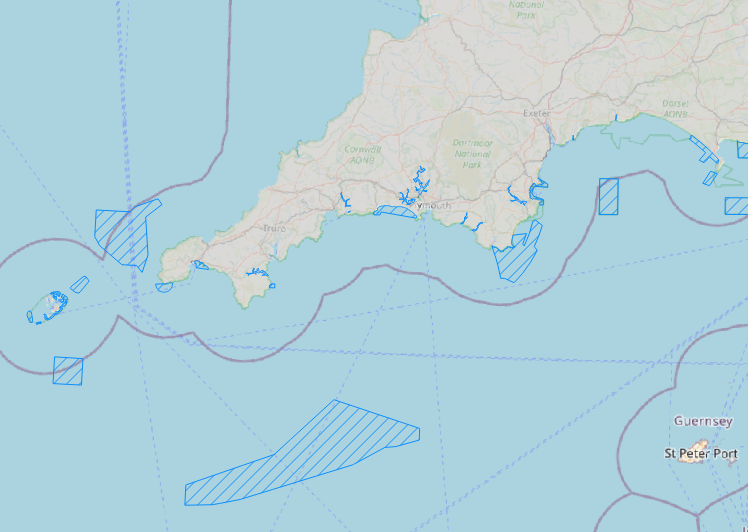
British Marine Conservation Zones (MCZ) in the English Channel
British Marine Conservation Zone (MCZ) boundaries in the English Channel waters.
Simple
- Title
-
British Marine Conservation Zones (MCZ) in the English Channel
- Date (Publication)
- 2023-01-20
- Citation identifier
- DOI:10.12770/62d38428-b61f-49ef-bf2e-244988d4d8a2
- Abstract
-
British Marine Conservation Zone (MCZ) boundaries in the English Channel waters.
- Credit
-
FISH INTEL Project - Interreg EU Channel-Manche
Digital and Data Solutions, JNCC
- Point of contact
-
Organisation name Individual name Electronic mail address Role UMR 6308 AMURE - UBO
Eider GRANER
Author University of Plymouth
Alice HALL
Author Digital and Data Solutions, JNCC
Product manager University of Plymouth
Emma SHEEHAN
Local service desk
-
Thèmes Sextant
-
-
/Biological Environment/Habitats
-
-
GEMET - INSPIRE themes, version 1.0
-
-
Habitats and biotopes
-
- Keywords
-
-
Marine Conservation Zones
-
- Use limitation
- Open Licence
- Access constraints
- Copyright
- Use constraints
- Copyright
- Other legal constraints
-
Re-use of content is permitted free of charge, provided that the sources are acknowledged.
Copyrights Contains Joint Nature Conservation Committee data © copyright and database right [2019]. Contains Natural England data © copyright and database right [2019]. Environment Agency data © copyright and database right [2019]. Contains UK Hydrographic Office data © copyright and database right [2019]. FISH INTEL EU Interreg Channel-Manche project.
DO NOT USE FOR NAVIGATION.
- Spatial representation type
- Vector
- Denominator
- 25000
- Language
- English
- Character set
- UTF8
- Topic category
-
- Oceans
))
- Unique resource identifier
- EPSG:27700
- Geometric object type
- Surface
- Distribution format
-
Name Version
- OnLine resource
-
Protocol Linkage Name null
https://fishintel.ifremer.fr/ Site internet du projet FISH INTEL
null
https://www.plymouth.ac.uk/research/marine-conservation-research-group/fish-intel-interreg FISH INTEL Website - University of Plymouth
WWW:LINK
https://ows.jncc.gov.uk/mpa_mapper/wms OGC:WFS
https://sextant.ifremer.fr/services/wfs/fishintel OGC:WMS
https://sextant.ifremer.fr/services/wms/fishintel MCZ_UK_FISHINTEL
- Hierarchy level
- Dataset
Conformance result
- Title
-
RÈGLEMENT (UE) N o 1089/2010 DE LA COMMISSION du 23 novembre 2010 portant modalités d'application de la directive 2007/2/CE du Parlement européen et du Conseil en ce qui concerne l'interopérabilité des séries et des services de données géographiques
- Date (Publication)
- 2010-12-08
- Explanation
-
See the referenced specification
- Statement
-
This resource relates to a Web Map Service (WMS) layer showing Marine Conservation Zone (MCZ) boundaries in UK waters - English Channel Area. The raw data layer was reworked as part of the FISH INTEL Interreg EU Channel project (https://fishintel.ifremer.fr/) to produce a map of ecosystem services and marine habitats in the Channel. These data are part of the catalogue ''FISH INTEL - Fisheries Innovation for sustainable INTerchannEL resources''. The original data was last updated in May 2019. JNCC have compiled this dataset using data from JNCC, Natural England, Northern Irish Environment Agency, Natural Resource Wales and the United Kingdom Hydrographic Office.
Marine Conservation Zones are designated under the Marine and Coastal Access Act (2009) or Marine Act (Northern Ireland) 2013. They protect nationally important marine wildlife, habitats, geology and geomorphology.
The layer is available to view on the JNCC MPA mapper and can also be accessed via our WMS: https://ows.jncc.gov.uk/mpa_mapper/wms
The MCZ boundaries are available to download from the following places:
Offshore MCZs – as part of the offshore MPA dataset
Welsh MCZs – http://lle.gov.wales/catalogue/item/ProtectedSitesMarineNatureReserves/?lang=en
English inshore MCZs – https://naturalengland-defra.opendata.arcgis.com/datasets/marine-conservation-zones-england
Inshore Northern Irish MCZs – please contact Marine.InfoRequests@daera-ni.gov.uk
Metadata
- File identifier
- 62d38428-b61f-49ef-bf2e-244988d4d8a2
- Metadata language
- English
- Other language
-
Language Character encoding French UTF8
- Character set
- UTF8
- Hierarchy level
- Dataset
- Date stamp
- 2023-02-16T14:38:10.706Z
- Metadata standard name
-
ISO 19115:2003/19139 - SEXTANT
- Metadata standard version
-
1.0
- Metadata author
-
Organisation name Individual name Electronic mail address Role UMR 6308 AMURE - UBO
Eider GRANER
Author University of Plymouth
Alice HALL
Author University of Plymouth
Emma SHEEHAN
Local service desk
accessData
Overviews
)))