Regional (Europe) gridded L4 Currents reprocessed (1993-ongoing) & NRT
Multimission altimeter satellite gridded sea surface heights and derived variables computed with respect to a twenty-year mean. Previously distributed by Aviso+, no change in the scientific content. All the missions are homogenized with respect to a reference mission. The acquisition of various altimeter data is a few days at most. The sla is computed with a non-centered computation time window (6 weeks before the date).
Simple
- Title
-
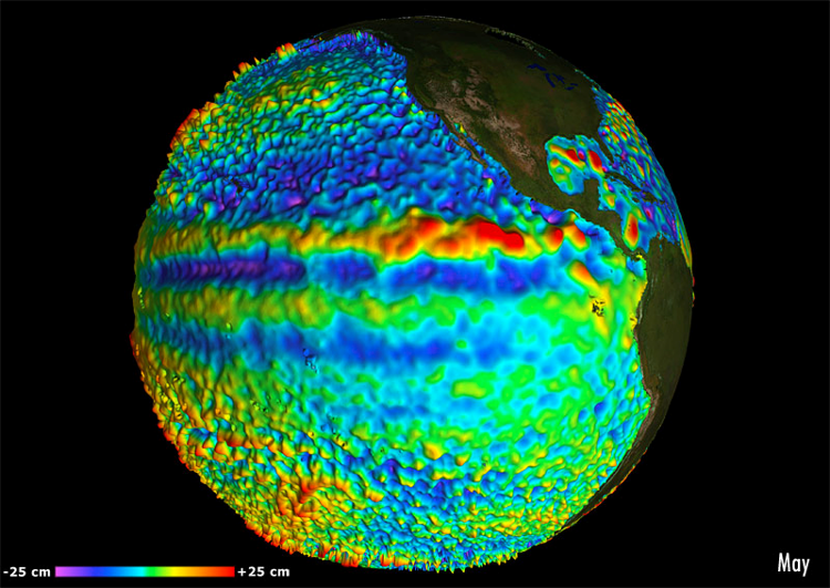
Regional (Europe) gridded L4 Currents reprocessed (1993-ongoing) & NRT
- Date (Creation)
- 2013-01-01
- Abstract
-
Multimission altimeter satellite gridded sea surface heights and derived variables computed with respect to a twenty-year mean. Previously distributed by Aviso+, no change in the scientific content. All the missions are homogenized with respect to a reference mission. The acquisition of various altimeter data is a few days at most. The sla is computed with a non-centered computation time window (6 weeks before the date).
- Credit
-
Marine Core Service, AVISO+
- Point of contact
-
Organisation name Individual name Electronic mail address Role Copernicus
Marine Core Service
Local service desk CNES
AVISO+
Local service desk
-
Centre de données ODATIS
-
-
CDS-SAT-AVISO
-
- Keywords
-
-
Type de jeux de donnée ODATIS
-
-
/Remote sensing
-
-
Thèmatiques ODATIS
-
-
Operational oceanography
-
-
ODATIS aggregation parameters and Essential Variable names
-
-
Currents
-
Sea surface height
-
- Access constraints
- License
- Use constraints
- License
- Other legal constraints
-
Les conditions spécifiques de la licence sont détaillées dans http://marine.copernicus.eu/services-portfolio/service-commitments-and-licence/
- Spatial representation type
- Grid
- Language
- Français
- Character set
- UTF8
- Topic category
-
- Oceans
))
- Begin date
- 2013-01-01
- Geometric object type
- Complex
- Distribution format
-
Name Version
- OnLine resource
- Hierarchy level
- Dataset
- Statement
-
Detailed description:
This product is processed by the SL-TAC multimission altimeter data processing system. It serves in near-real time the main operational oceanography and climate forecasting centers in Europe and worldwide. It processes data from all altimeter missions: Jason-3, Sentinel-3A, HY-2A, Saral/AltiKa, Cryosat-2, Jason-2, Jason-1, T/P, ENVISAT, GFO, ERS1/2. It provides a consistent and homogeneous catalogue of products for varied applications, both for near real time applications and offline studies.
Horizontal sampling:
1/8 degree
Metadata
- File identifier
- 62fca52c-83ed-40f1-ba6e-1c9088330b79
- Metadata language
- Français
- Other language
-
Language Character encoding English UTF8
- Character set
- UTF8
- Parent identifier
-
Produits altimétriques global MSLA et MADT - Courants (multimissions, niveau 4)
39498dd6-60fe-4377-b1ea-d0b40d2cecd3
- Hierarchy level
- Dataset
- Date stamp
- 2022-02-03T14:42:36.512Z
- Metadata standard name
-
ISO 19115:2003/19139 - SEXTANT
- Metadata standard version
-
1.0
accessData
Overviews
)))