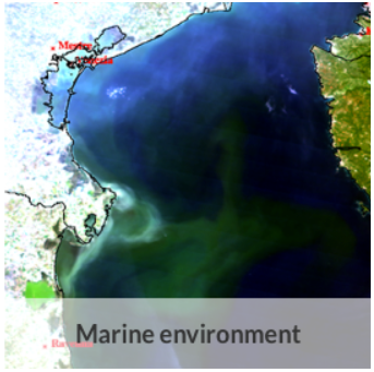
Chlorophyll pigment concentrations in water bodies | Concentration of chlorophyll-a {chl-a CAS 479-61-8} per unit volume of the water body by synthesis from multiple satellite sensors | Copernicus Marine Environment Monitoring Service | Mediterranean Sea Surface Chlorophyll Concentration from Multi Satellite observations Reprocessed (ESA-CCI) (1997-2012)
Simple
Identification info
- Alternate title
-
Mediterranean Sea Surface Chlorophyll Concentration from Multi Satellite observations Reprocessed (ESA-CCI) (1997-2012)
- Date
- Citation identifier
- Chlorophyll pigment concentrations in water bodies | Concentration of chlorophyll-a {chl-a CAS 479-61-8} per unit volume of the water body by synthesis from multiple satellite sensors | Copernicus Marine Environment Monitoring Service | Mediterranean Sea Surface Chlorophyll Concentration from Multi Satellite observations Reprocessed (ESA-CCI) (1997-2012)
- Purpose
-
This product is meant for use for educational purposes and for the managing of the marine safety, marine resources, marine and coastal environment and for climate and seasonal studies.
- Status
- On going
- Point of contact
-
Organisation Individual Electronic mail address ORCID Role Copernicus Marine Environment Monitoring Service
CMEMS
edmerp Copernicus Marine Environment Monitoring Service
edmo ISAC - Institute of Atmospheric Sciences and Climate (Rome)
Originator
- Spatial representation type
- Vector
Spatial resolution
- Spatial resolution
- 4000
- Topic category
-
- Oceans
Extent
))
Extent
- Time period
- 1997-09-04T00:00:00 2015-08-31T00:00:00
Vertical element
- Minimum value
- 0
- Maximum value
- 0
- Maintenance and update frequency
- As needed
- Used by challenges
-
-
MedSea - CH06 - Marine Environment
-
- Environmental matrix
-
-
Marine water
-
- Production mode
-
-
Delayed
-
- Parameter Discovery Vocabulary (P02)
-
-
Chlorophyll pigment concentrations in water bodies
-
- GEMET - INSPIRE themes, version 1.0
-
-
Oceanographic geographical features
-
- Processing level of characteristics
-
-
High level analyzed
-
- Data delivery mechanisms
-
-
Online discovery + downloading + viewing services (Advanced services)
-
- Parameter Usage Vocabulary (P01)
-
-
Concentration of chlorophyll-a {chl-a CAS 479-61-8} per unit volume of the water body by synthesis from multiple satellite sensors
-
- Agreed Parameter Groups (P03)
-
-
Pigments
-
- Service extent
-
-
The datasets are provided through an EU Inspire catalogue service (OGC)
-
- Visibility
-
-
Search via reference catalogue (e.g. MyOcean, GEOSS Geoportal…)
-
- Policy visibility
-
-
There is detailed information provided to understand data policy
-
- Readyness
-
-
Format not proprietary and content clearly specified (e.g. autodescriptive like ODV, NetCDF CF) or at least with appropriate document describing the content
-
- Validation
-
-
Submitted
-
Resource constraints
- Access constraints
- Other restrictions
- Other constraints
-
Accessible under moratorium
Resource constraints
- Use limitation
-
Open and Free. No charge
- Language
- Français
- Character encoding
- UTF8
- Environment description
-
Environmental Monitoring
- To advance the scientific understanding of marine ecosystems, and provide information, knowledge, and advice on the sustainable management of human activities affecting, and affected by, marine ecosystems
- To develop tools for the evaluation of the environmental status
-To implement the principles and objectives put forward in the Marine Strategy Framework Directive (MSFD)
Content Information
- Attribute description
- observation
- Content type
- Physical measurement
Distribution Information
- Distribution format
-
-
NetCDF
-
- OnLine resource
-
Mediterranean Sea Surface Chlorophyll Concentration from Multi Satellite observations Reprocessed (ESA-CCI)
- OnLine resource
-
OCEANCOLOUR_MED_CHL_L4_REP_OBSERVATIONS_009_078
MEDSEA_CH6_Product_3 / Maps of average TRIX indices calculated from Mediterranean sea surface data for the periods 2008-2012, 1998-2002, and 1993-1997
- Begin date
- 1997-01-01T00:00:00
- End date
- 2015-12-31T00:00:00 After
Vertical element
- Minimum value
- 0
- Maximum value
- 5
MEDSEA_CH6_Product_4 / Maps showing differences between most recent TRIX estimates (2008-2012) and TRIX from the earlier periods 1998-2002 and 1993-1997
- Begin date
- 1993-01-01T00:00:00
- End date
- 2002-12-31T00:00:00 After
Vertical element
- Minimum value
- 0
- Maximum value
- 5
Resource lineage
- Hierarchy level
- Dataset
Spatial representation info
- Number of dimensions
- 0
- Axis dimension properties
-
Dimension name Dimension size Resolution Time 1 day
- Cell geometry
- Transformation parameter availability
- true
- Check point availability
- true
Metadata
- Metadata identifier
- urn:uuid/65856bec-7740-430b-b5dd-ac7d639d7c2c
- Language
- English
- Character encoding
- UTF8
- Contact
-
Organisation Individual Electronic mail address ORCID Role CNR-ISAC
Point of contact
Type of resource
- Resource type
- Dataset
- Name
-
MedSea - CH06 - Marine Environment
- Metadata linkage
-
https://sextant.ifremer.fr/geonetwork/srv/eng//metadata/65856bec-7740-430b-b5dd-ac7d639d7c2c
- Metadata linkage
-
https://sextant.ifremer.fr/geonetwork/srv/fre//metadata/65856bec-7740-430b-b5dd-ac7d639d7c2c
- Date info (Revision)
- 2017-08-24T12:29:46Z
- Date info (Creation)
- 2015-04-29T15:01:07
Metadata standard
- Title
-
ISO 19115-3 - Emodnet Checkpoint - Upstream Data
- Edition
-
1.0
accessData
Overviews

Spatial extent
)))