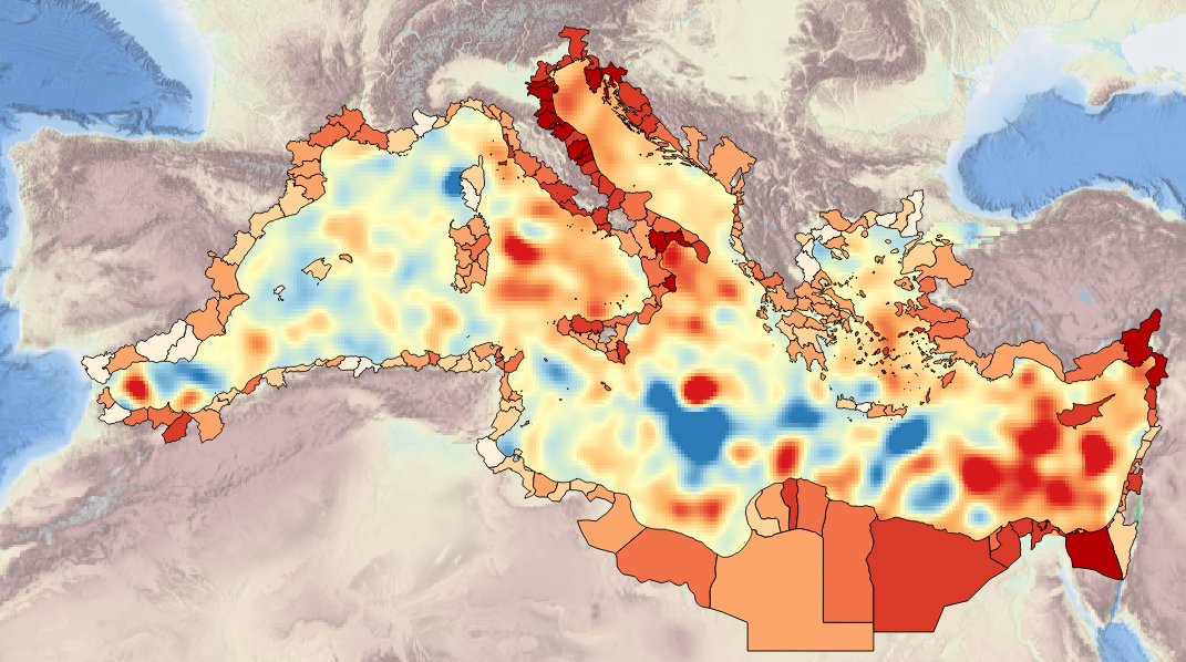
MEDSEA_CH4_Product_5 / Spatial layer of sea-level trend from AVISO reconstruction over period of 10 years (2003 – 2012)
Description ot the spatial layers attributes of sea level trend for the last 10 years for the Mediterranean basin and for each NUTS3 region along the coast.
Simple
Identification info
- Date (Creation)
- 2016-11-21
- Citation identifier
- DOI:10.12770/6a4bd162-1dd4-412c-a2a1-094ca4884499
- Issue identification
-
MEDSEA D5.3.5
- Purpose
-
Produce spatial layers of sea level trend for the past 10 years
- Credit
-
EMODnet Medsea Checkpoint
- Point of contact
-
Organisation Individual Electronic mail address ORCID Role CLS
Point of contact EMODnet Medsea Checkpoint
Publisher CLS
Author
- Spatial representation type
- Grid
- Topic category
-
- Oceans
Extent
))
Extent
- Time period
- 1992-10-01 2012-12-31
Vertical element
- Minimum value
- 0
- Maximum value
- 0
- Used by challenges
-
-
MedSea - CH04 - Climate and Coastal Protection
-
- Processing level of characteristics
-
-
High level analyzed
-
- Production mode
-
-
Delayed
-
- GEMET - INSPIRE themes, version 1.0
-
-
Oceanographic geographical features
-
- Theme
-
-
sea-level trend
-
satellite altimetry
-
Resource constraints
- Use limitation
-
Consult Medsea_Checkpoint fitness for puprose documents
- Use constraints
Associated resource
- Association Type
- Cross reference
- Initiative Type
- specification
Associated resource
- Association Type
- Cross reference
- Initiative Type
- upstreamData
Associated resource
- Association Type
- Cross reference
- Initiative Type
- upstreamData
Associated resource
- Association Type
- Cross reference
- Initiative Type
- upstreamData
Associated resource
- Association Type
- Cross reference
- Initiative Type
- upstreamData
- Language
- English
- Character encoding
- UTF8
Distribution Information
- Distribution format
-
-
NetCDF
-
- OnLine resource
-
DOI of the product
DOI of the product
- OnLine resource
-
CH4_product_5
Product visualization
MEDSEA_CH4_Product_5 / Spatial layer of sea-level trend from AVISO reconstruction over period of 10 years (2003 – 2012) - Basin spatial layer of sea level trend for the last 10 yrs
- Begin date
- 1992-10-01
- End date
- 2012-07-31
Vertical element
- Minimum value
- 0
- Maximum value
- 0
MEDSEA_CH4_Product_5 / Spatial layer of sea-level trend from AVISO reconstruction over period of 10 years (2003 – 2012) - NUTS3 region spatial layer of sea level trend for the last 10 yrs
- Begin date
- 2003-01-01
- End date
- 2012-12-31
Vertical element
- Minimum value
- 0
- Maximum value
- 0
Metadata
- Metadata identifier
- urn:uuid/6a4bd162-1dd4-412c-a2a1-094ca4884499
- Language
- English
- Character encoding
- UTF8
Type of resource
- Resource type
- Dataset
- Metadata linkage
-
http://localhost:8080/geonetwork/srv/eng//metadata/286d8887-58a5-4562-a0b9-a69b78fced76
- Metadata linkage
-
http://localhost:8080/geonetwork/srv/eng//metadata/47dea01f-5b6a-48d7-990a-606a6001cbef
- Metadata linkage
-
https://sextant.ifremer.fr/geonetwork/srv/eng//metadata/6a4bd162-1dd4-412c-a2a1-094ca4884499
- Metadata linkage
-
https://sextant.ifremer.fr/geonetwork/srv/fre//metadata/6a4bd162-1dd4-412c-a2a1-094ca4884499
- Date info (Revision)
- 2017-08-24T12:29:50Z
- Date info (Creation)
- 2005-03-31T19:13:30
Metadata standard
- Title
-
ISO 19115-3 - Emodnet Checkpoint - Targeted Data Product
accessData
Overviews
Spatial extent
)))