VACLAN (Variabilidad Climatica en el Atlantico Norte) North Atlantic 2003-
The aim of this project is to implement a sampling network in order to study climate variability in ocean water around the Iberian peninsula and the Bay of Biscay, to determine the flows of heat, freshwater, nutrients and C02 in wastewater, and relationship with NAO. This contributed to international climate change programmes and to the beginning of systematic study of the region. Furthermore, it facilitates the use of a digital model in the region.
The main aim of the VACLAN project is to improve observation capacity and the use of the new tools available used to characterize climate change: remote sensing for the study of surface waters, drifting buoys for upper and mid waters, and moored instruments and hydrographic stations for studying the water column.
The use of these tools along with digital modelling will make it possible to characterize CO2 flow and the physio-chemical flow in such a large area, where the border current is the Atlantic. Furthermore, once checked and validated, the data in this system will be made available for academic scientific communities and included in digital forecasting models.
Simple
- Title
-
VACLAN (Variabilidad Climatica en el Atlantico Norte) North Atlantic 2003-
- Date (Creation)
- 2003-01-01T00:00:00
- Citation identifier
- FR-DCSMM-PDS-PROJET-VACLAN
- Presentation form
- Digital profile
- Abstract
-
The aim of this project is to implement a sampling network in order to study climate variability in ocean water around the Iberian peninsula and the Bay of Biscay, to determine the flows of heat, freshwater, nutrients and C02 in wastewater, and relationship with NAO. This contributed to international climate change programmes and to the beginning of systematic study of the region. Furthermore, it facilitates the use of a digital model in the region.
The main aim of the VACLAN project is to improve observation capacity and the use of the new tools available used to characterize climate change: remote sensing for the study of surface waters, drifting buoys for upper and mid waters, and moored instruments and hydrographic stations for studying the water column.
The use of these tools along with digital modelling will make it possible to characterize CO2 flow and the physio-chemical flow in such a large area, where the border current is the Atlantic. Furthermore, once checked and validated, the data in this system will be made available for academic scientific communities and included in digital forecasting models.
- Credit
-
Data producers: Spanish Ocenographic Institute, Vigo University, Vigo Marine Research Institute
- Status
- Completed
- Maintenance and update frequency
- Not planned
- Maintenance note
-
Network duration: temporary network
- Theme
-
-
Climate change
-
Observation
-
Sampling
-
Temperature
-
Total Alkalinity
-
Inorganic carbon content
-
Nutrients
-
Current
-
ADCP
-
CTD
-
Niskin bottle
-
Iberian Coast
-
-
GEMET - INSPIRE themes, version 1.0
-
-
Environmental monitoring facilities
-
-
Sous-regions marines
-
-
Bay of Biscay
-
-
DCSMM : Type d'espace concerné
-
-
Pas d'espace particulier concerné
-
-
DCSMM : Descripteurs
-
-
D1: Biodiversity
-
D4: Marine Food Webs
-
-
DCSMM : Méthodes de recueil des données
-
-
Observation par point
-
Observation par transect
-
-
Thèmes Sextant
-
-
/Physical Environment/Climatology
-
- Access constraints
- Other restrictions
- Other legal constraints
-
Conditions d'accès :inconnues
- Use limitation
-
Unknown conditions
- Spatial representation type
- Vector
- Denominator
- 500000
- Language
- Français
- Character set
- UTF8
- Topic category
-
- Biota
))
- Supplemental Information
-
Project leader :
Spanish Ministry for Education and Science
Prime contractor :
Spanish Ocenographic Institute
Université of Vigo
Vigo Marine Research Institute
Backer :
Spanish Ministry for Education and Science
- Reference system identifier
- EPSG / WGS 84 (EPSG:4326) / 7.9
- Topology level
- Geometry only
- Geometric object type
- Complex
- Geometric object count
- 0
- Hierarchy level
- Dataset
Conformance result
- Title
-
Inspire specifications
- Date (Creation)
- 2012-01-16
- Explanation
-
Non assessed
- Pass
- Statement
-
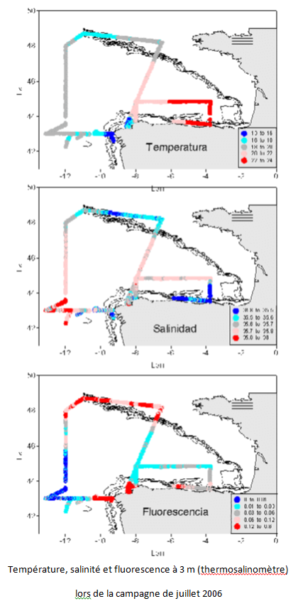
In these campaigns, hydrographic sampling methods are followed in accordance with the protocol established in the Gyroscope project (Parrilla et al., 2002)
The calibration of the equipment used in the VACLAN project campaign is essential : laboratory quality assurance measurements have been implemented for meticulous calibration of the sensors, both prior to and following the campaign (WOCE methodology). Comparisons with historic data were also carried out simultaneously.
- Description
-
Data type :
Hydrodynamics
Hydrology Biogeochemistry
Measured or observed parameters:
Current
Temperature
Salinity Pressure
Nutrients (nitrates, nitrite, silicate, phosphate) Fluorescence
TC (total inorganic carbon)
Alkalinity pH pCO2 MOD
Parameters resolution :
Accuracy : 0.001°C
Resolution : 0.0002 °C, Accuracy : 0.0003 S/m, Resolution : 0.00004 S/m, Accuracy : 1.02dbar, Resolution : 0.1dbar
- Description
-
Sampling method : spatial
Metadata
- File identifier
- 71979dc3-bb67-4da2-a55b-4cf2b3ad07d5
- Metadata language
- Français
- Other language
-
Language Character encoding English
- Character set
- UTF8
- Hierarchy level
- Dataset
- Date stamp
- 2020-06-04T01:07:42
- Metadata standard name
-
ISO 19115:2003/19139 - SEXTANT
- Metadata standard version
-
1.0
- Metadata author
-
Organisation name Individual name Electronic mail address Role Sextant
Local service desk
accessData
Overviews
)))