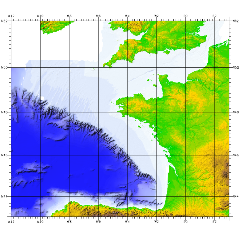
Regional Bathy-morphology of the Bay of Biscay and the English Channel (2008 edition, resolution 500 and 1000 m)
This bathymetric model is the result of compiling data and numerical models prior to 2008 in the Bay of Biscay.
These datasets are available at a resolution of 500 m and 1000 m. Contours are also available for both digital terrain model (DTM).
Public access granted under certain conditions.
Simple
- Title
-
Regional Bathy-morphology of the Bay of Biscay and the English Channel (2008 edition, resolution 500 and 1000 m)
- Alternate title
-
Synthese_MancheGascogne_1000m_BATHY
- Alternate title
-
Synthese_MancheGascogne_1000m_Isobathes100m
- Alternate title
-
Synthese_MancheGascogne_500m_BATHY
- Alternate title
-
Synthese_MancheGascogne_500m_Isobathes50m
- Date (Publication)
- 2010-01-01T00:00:00
- Date (Creation)
- 2008-01-01T00:00:00
- Edition
-
édition Ifremer-SHOM
- Edition date
- 2010-01-01T00:00:00
- Citation identifier
- FR-330-715-368-00032-Synthese_MancheGascogne_1000m_BATHY
- Presentation form
- Digital map
- Abstract
-
This bathymetric model is the result of compiling data and numerical models prior to 2008 in the Bay of Biscay.
These datasets are available at a resolution of 500 m and 1000 m. Contours are also available for both digital terrain model (DTM).
Public access granted under certain conditions.
- Credit
-
© Ifremer-SHOM, © British Crown and Sezone Solutions Limited, 2010
- Status
- On going
- Point of contact
-
Organisation name Individual name Electronic mail address Role Ifremer - Géosciences Marines
Owner SHOM
Owner Ifremer - Géosciences Marines
Author SHOM
Author
- Maintenance and update frequency
- Not planned
-
Thèmes Sextant
-
-
/Physical Environment/Bathymetry/Bathymetric Contours
-
/Physical Environment/Bathymetry/Digital Terrain Model
-
-
GEMET - INSPIRE themes, version 1.0
-
-
Elevation
-
-
external.theme.gemet
-
-
seabed
-
underwater morphology
-
- Theme
-
-
bathymetry
-
Digital Terrain Model
-
- Place
-
-
Bay of Biscay
-
English Channel
-
Atlantic
-
- Discipline
-
-
Geophysics
-
-
Sous-regions marines
-
-
/Metropolitan France/Bay of Biscay
-
/Metropolitan France/Channel-North Sea
-
/Metropolitan France/Celtic Seas
-
-
Thématiques - SIMM
-
-
Research
-
/Environmental Status/Bathymetry
-
-
Type de jeux de donnée ODATIS
-
-
/Processed data/Composite products
-
-
Ocean Hackathon - Ville et défi
-
-
/Boulogne-sur-Mer
-
/Brest
-
/Cherbourg
-
/La Rochelle
-
/Bournemouth
-
/Plymouth
-
- Use limitation
-
Use prohibited for commercial use.
- Use limitation
-
Distribution and modification prohibited without the consent of the distributor.
- Use limitation
-
Do not use for navigation
- Access constraints
- Other restrictions
- Use constraints
- Copyright
- Use constraints
- License
- Other legal constraints
-
Required citation: © Ifremer, SHOM, 2010
- Other legal constraints
-
Required citation: © British Crown and Sezone Solutions Limited
- Other legal constraints
-
Required citation: LOUBRIEU B., BOURILLET J.F., MOUSSAT E., Regional Bathy-morphology of the Bay of Biscay and the English Channel, digital model 2008. Internal Ifremer report DCD/GM/CTDI/08-01
- Other legal constraints
-
This product has been derived in part from material obtained from the UK Hydrographic Office with the permission of the controller of Her Majesty's Stationery Office and UK Hydrographic Office (www.ukho.gov.uk). NOT TO BE USED FOR NAVIGATION. "© British Crown and Sezone Solutions Limited. All rights reserved. Products License n° 112006.004."
- Other legal constraints
-
Distribution outside of Ifremer is permitted excluding British waters
- Spatial representation type
- Grid
- Denominator
- 1000000
- Language
- Français
- Character set
- UTF8
- Topic category
-
- Elevation
))
- Begin date
- 1970-01-01T14:48:00
- End date
- 2007-01-01T14:48:00
- Reference system identifier
- EPSG / WGS 84 / World Mercator (EPSG:3395) / 7.4
- Number of dimensions
- 2
- Dimension name
- Row
- Dimension size
- 1033
- Resolution
- 1000 m
- Dimension name
- Column
- Dimension size
- 1162
- Resolution
- 1000 m
- Cell geometry
- Point
- Transformation parameter availability
Distributor
- Distributor contact
-
Organisation name Individual name Electronic mail address Role SHOM
Dissemination Unit
- Distributor format
-
Name Version
- Distributor contact
-
Organisation name Individual name Electronic mail address Role Ifremer - Centre de Brest
Administrateur du serveur Sextant
Dissemination Unit
- OnLine resource
-
Protocol Linkage Name WWW:LINK
http://www.shom.fr/ WWW:LINK
https://data.ifremer.fr/ Ifremer - accès aux données
- OnLine resource
-
Protocol Linkage Name OGC:WMS
https://sextant.ifremer.fr/services/wms/gm_bathy Synthese_MancheGascogne_1000m_BATHY
COPYFILE
Synthese_MancheGascogne_1000m_BATHY
OGC:WMS
https://sextant.ifremer.fr/services/wms/gm_bathy Synthese_MancheGascogne_500m_BATHY
COPYFILE
Synthese_MancheGascogne_500m_BATHY
OGC:WMS
https://sextant.ifremer.fr/services/wms/gm_bathy Synthese_MancheGascogne_1000m_Isobathes100m
COPYFILE
Synthese_MancheGascogne_1000m_Isobathes100m
OGC:WMS
https://sextant.ifremer.fr/services/wms/gm_bathy Synthese_MancheGascogne_500m_Isobathes50m
COPYFILE
Synthese_MancheGascogne_500m_Isobathes50m
- Hierarchy level
- Dataset
Vertical extent
- Minimum value
- -5174
- Maximum value
- 2330
Vertical CRS
Vertical CS
Vertical datum
Conformance result
- Title
-
INSPIRE
- Date (Publication)
- 2007-03-14
- Explanation
-
not evaluated
- Pass
- Statement
-
The terrain model includes six main sources of data or information.
Source1: Ifremer multibeam data, primarily the mapping result of the French EEZ in the Gulf of Biscay published in 2000 and the data derived from multibeam systems Seabeam, EM12D, and EM300 as well as data from the SHOM database;
Source2: Extraction from the SHOM database, probes sampled in 500m² cells (SHOM contract E97/2006) across the continental shelf English Channel / Atlantic;
Source3: Extractions from the database of the UK Hydrographic Service for the English Channel (contract Seazone Solutions Ltd - license number 11206.004);
Source4: Berthois Maps of the Bay of Biscay (1974 and 1983) digitized (2000) with a sampling interval of 500m;
Source5: Version before 2006 of the Gold of Biscay DTM with a grid pitch of 500m;
Source6: SRTM topographic model at 30 arc seconds.
- Description
-
DTM1: The grid pitch of 500m is sampled at 1km grid intervals. Its geographical extension provides the following operational results:
- DTM2: DTM sampling of the version before 2006 (Source5) for depths between 5500m and 300m.
- DTM3: Extraction of the cantabrian margin area of the same DTM source S5 (unlimited depth).
Aggregation of the 2 DTMs (DTM2 and DTM3) to DTM1 to obtaining the product Bay of Biscay - English Channel, at 1km resolution.
Metadata
- File identifier
- 7462a470-b290-11de-b102-000086f6a603
- Metadata language
- Français
- Other language
-
Language Character encoding English
- Character set
- UTF8
- Hierarchy level
- Dataset
- Date stamp
- 2023-12-07T13:50:29.446Z
- Metadata standard name
-
ISO 19115:2003/19139 - SEXTANT
- Metadata standard version
-
1.0
- Metadata author
-
Organisation name Individual name Electronic mail address Role Ifremer - Géosciences Marines
Local service desk
accessData
Overviews
)))